

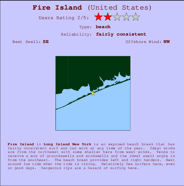
Fire Island Surf Guide
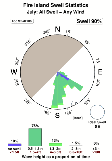
Fire Island in Long Island NY is an exposed beach break that has pretty consitent surf and can work at any time of the year. Ideal winds are from the northwest with some shelter here from west winds. Tends to receive a mix of groundswells and windswells and the best swell direction is from the southeast. The beach break provides left and right handers. Best around low tide when the tide is rising. It very rarely gets crowded here. Dangerous rips are a hazard of surfing here.
Fire Island Spot Info
| Type: | Rating: | Reliability: | Todays Sea Temp*: |
|---|---|---|---|
| fairly consistent | 22.7°C*ocean temperature recorded from satellite |
Surfing Fire Island:
The best conditions reported for surf at Fire Island occur when a Southeast swell combines with an offshore wind direction from the Northwest.

Énergie de Vague (puissance): 12h


Fire Island Surf:
Sunday, 19 July 2026, 08:49 Local time| Dimanche 19 | ||||
| 5AM | 8AM | 11AM | 2PM | |
| Wave (m) | ||||
| Période (s) | 6 | 6 | 6 | 6 |
| Vent (km/h) | ||||
| Etat du vent | cross- off |
off | cross- off |
off |
- /breaks/Fire-Island/forecasts/latest
Fire Island Surf Guide
Fire Island in Long Island NY is an exposed beach break that has pretty consitent surf and can work at any time of the year. Ideal winds are from the northwest with some shelter here from west winds. Tends to receive a mix of groundswells and windswells and the best swell direction is from the southeast. The beach break provides left and right handers. Best around low tide when the tide is rising. It very rarely gets crowded here. Dangerous rips are a hazard of surfing here.
Fire Island Spot Info
Type: Rating: Reliability: Todays Sea Temp*:  Beach
Beach 2
2fairly consistent 22.7°C*ocean temperature recorded from satelliteSurfing Fire Island:
The best conditions reported for surf at Fire Island occur when a Southeast swell combines with an offshore wind direction from the Northwest.
Énergie de Vague (puissance): 12h
Utilisez les onglets ci-dessus pour voir la température de la mer à Fire Island, photos pour Fire Island, prévisions de houle détaillées pour Fire Island, prévisions de vent et météo, webcams pour Fire Island, conditions de vents en temps réel à partir des données de la station météo de Long Island NY et prévisions des marées pour Fire Island. Les cartes de houle pour United States afficheront une image agrandie de United States et des ses mers environnantes. Ces cartes de houles peuvent êtres animées pour montrer les différents composantes de houle, la hauteur, la période et l'énergie des vagues avec les prévisions météo et prévisions de vent. Des observations en temps réel du temps et de l'état de la mer sont fournies grâce aux bouées marines de United States, des navires de passages, et des stations météo côtières. Toutes les pages de prévisions pour ce spot de surf ont un Vagu-o-Mètre Local et Global pour facilement trouver les meilleurs spot de surf à proximité de Fire Island.
Fire Island Surf:
Sunday, 19 July 2026, 08:49 Local timeDimanche 19 5AM 8AM 11AM 2PM Wave (m) Période (s) 6 6 6 6 Vent (km/h) Etat du vent cross-
offoff cross-
offoff - /breaks/Fire-Island/forecasts/latest
- /breaks/Fire-Island/forecasts/latest/six_day
Fire Island Surf Guide
Fire Island in Long Island NY is an exposed beach break that has pretty consitent surf and can work at any time of the year. Ideal winds are from the northwest with some shelter here from west winds. Tends to receive a mix of groundswells and windswells and the best swell direction is from the southeast. The beach break provides left and right handers. Best around low tide when the tide is rising. It very rarely gets crowded here. Dangerous rips are a hazard of surfing here.
Fire Island Spot Info
Type: Rating: Reliability: Todays Sea Temp*: Beach2fairly consistent 22.7°C*ocean temperature recorded from satelliteSurfing Fire Island:
The best conditions reported for surf at Fire Island occur when a Southeast swell combines with an offshore wind direction from the Northwest.
Énergie de Vague (puissance): 12h
Utilisez les onglets ci-dessus pour voir la température de la mer à Fire Island, photos pour Fire Island, prévisions de houle détaillées pour Fire Island, prévisions de vent et météo, webcams pour Fire Island, conditions de vents en temps réel à partir des données de la station météo de Long Island NY et prévisions des marées pour Fire Island. Les cartes de houle pour United States afficheront une image agrandie de United States et des ses mers environnantes. Ces cartes de houles peuvent êtres animées pour montrer les différents composantes de houle, la hauteur, la période et l'énergie des vagues avec les prévisions météo et prévisions de vent. Des observations en temps réel du temps et de l'état de la mer sont fournies grâce aux bouées marines de United States, des navires de passages, et des stations météo côtières. Toutes les pages de prévisions pour ce spot de surf ont un Vagu-o-Mètre Local et Global pour facilement trouver les meilleurs spot de surf à proximité de Fire Island.
Fire Island Surf:
Sunday, 19 July 2026, 08:49 Local timeDimanche 19 5AM 8AM 11AM 2PM Wave (m) Période (s) 6 6 6 6 Vent (km/h) Etat du vent cross-
offoff cross-
offoff - /breaks/Fire-Island/forecasts/latest
Fire Island Surf Guide
Fire Island in Long Island NY is an exposed beach break that has pretty consitent surf and can work at any time of the year. Ideal winds are from the northwest with some shelter here from west winds. Tends to receive a mix of groundswells and windswells and the best swell direction is from the southeast. The beach break provides left and right handers. Best around low tide when the tide is rising. It very rarely gets crowded here. Dangerous rips are a hazard of surfing here.
Fire Island Spot Info
Type: Rating: Reliability: Todays Sea Temp*: Beach2fairly consistent 22.7°C*ocean temperature recorded from satelliteSurfing Fire Island:
The best conditions reported for surf at Fire Island occur when a Southeast swell combines with an offshore wind direction from the Northwest.
Énergie de Vague (puissance): 12h
Utilisez les onglets ci-dessus pour voir la température de la mer à Fire Island, photos pour Fire Island, prévisions de houle détaillées pour Fire Island, prévisions de vent et météo, webcams pour Fire Island, conditions de vents en temps réel à partir des données de la station météo de Long Island NY et prévisions des marées pour Fire Island. Les cartes de houle pour United States afficheront une image agrandie de United States et des ses mers environnantes. Ces cartes de houles peuvent êtres animées pour montrer les différents composantes de houle, la hauteur, la période et l'énergie des vagues avec les prévisions météo et prévisions de vent. Des observations en temps réel du temps et de l'état de la mer sont fournies grâce aux bouées marines de United States, des navires de passages, et des stations météo côtières. Toutes les pages de prévisions pour ce spot de surf ont un Vagu-o-Mètre Local et Global pour facilement trouver les meilleurs spot de surf à proximité de Fire Island.
Fire Island Surf:
Sunday, 19 July 2026, 08:49 Local timeDimanche 19 5AM 8AM 11AM 2PM Wave (m) Période (s) 6 6 6 6 Vent (km/h) Etat du vent cross-
offoff cross-
offoff Tide Times:
Pour Moriches Inlet, Long Island, New York, %{dist} %{km} de %{location}.
PROCHAIN EST A (heure locale) il reste marée haute marée basse Fire Island Tide Times and Tide Chart
Live Weather:
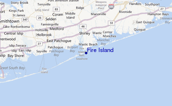
At Shirley Airport, 10 km from Fire Island.
light winds from the NW
(km/h)
ClearAir temperature
22.2°COverall Fire Island Surf Consistency and Wind Distribution in Juillet


Wind stats for Fire Island: see the variation in direction and stength by month.
Photos de Surf
de la galerieContours: Routes et Rivières: Sélectionnez un spot de surf du menu 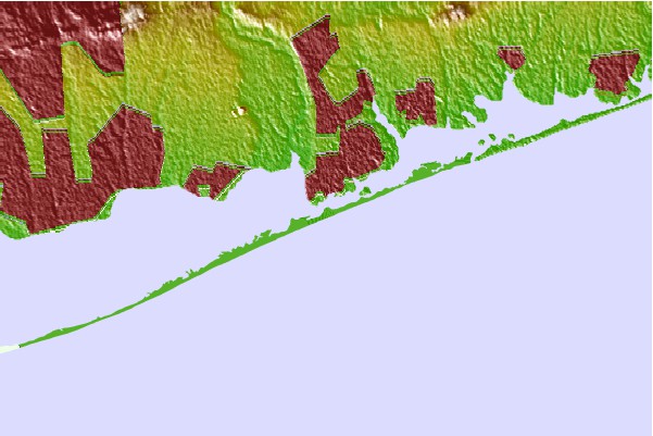
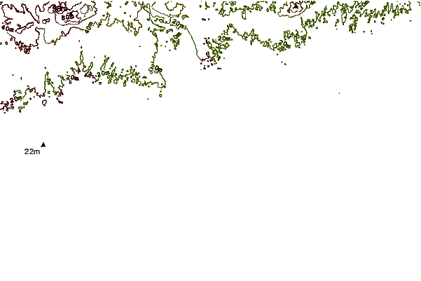
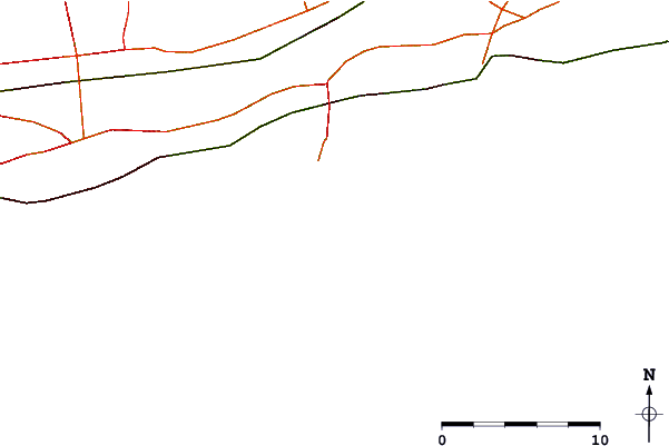
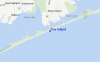
Utilisez cette carte en relief pour naviguer vers les spots de surf de Long Island NY, et les stations de marées aux alentours de Fire Island
Spots de Surf les plus proches de Fire Island:
(Cliquez sur le nom du spot pour plus de détails)- Closest spot9 mi
- Second closest spot11 mi
- Third closest spot15 mi
- Fourth closest spot20 mi
- Fifth closest spot21 mi
Bouées marines les plus proches de Fire Island:
- Closest Bouées marines30 mi
- Second closest Bouées marines37 mi
- Third closest Bouées marines40 mi
- Fourth closest Bouées marines43 mi
- Fifth closest Bouées marines50 mi
Stations de marée les plus proches de Fire Island:
- Closest station de maréeSmith Point Bridge, Narrow Bay, Long Island1 mi
- Second closest station de maréeMastic Beach, Moriches Bay, Long Island2 mi
- Third closest station de maréeBellport, Bellport Bay, Long Island4 mi
- Fourth closest station de maréeShirley5 mi
- Fifth closest station de maréeMoriches Inlet, Long Island6 mi
Airports
- The closest passenger airport to Fire Island is Long Island Mac Arthur (Islip) Airport (ISP) in USA, 21 km (13 miles) away (directly).
- The second nearest airport to Fire Island is The Francis S Gabreski (West Hampton Beach) Airport (FOK), also in USA, 23 km (14 miles) away.
- Third is Igor I Sikorsky Mem (Stratford) Airport (BDR) in USA, 53 km (33 miles) away.
- John F Kennedy International (New York) Airport (JFK) in USA is 78 km (48 miles) away.
- Westchester Co (White Plains) Airport (HPN), also in USA is the fifth nearest airport to Fire Island and is 80 km (50 miles) away.
- /breaks/Fire-Island/forecasts/latest
 Nearest