

Boat Basin Rights Surf Guide
Boat Basin Rights in Guam is an exposed reef break that has reasonably consistent surf. Offshore winds blow from the southeast. The ideal swell direction from the north. It very rarely gets crowded here. Beware of - Urchins - Rocks - Man-made danger (buoys etc.).
Boat Basin Rights Spot Info
| Type: | Rating: | Reliability: | Todays Sea Temp*: |
|---|---|---|---|
| fairly consistent | 29.1°C*ocean temperature recorded from satellite |
Surfing Boat Basin Rights:
The best conditions reported for surf at Boat Basin Rights occur when a North swell combines with an offshore wind direction from the Southeast.
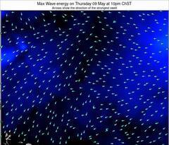
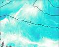
Énergie de Vague (puissance): 12h


Boat Basin Rights Surf:
Wednesday, 22 July 2026, 18:25 Local time| Mer | Jeu | |||
| 7PM | 10PM | 1AM | 4AM | |
| Wave (m) | ||||
| Période (s) | 9 | 9 | 9 | 9 |
| Vent (km/h) | ||||
| Etat du vent | glass | cross- on |
cross | cross |
- /breaks/Boat-Basin-Rights/forecasts/latest
Boat Basin Rights Surf Guide
Boat Basin Rights in Guam is an exposed reef break that has reasonably consistent surf. Offshore winds blow from the southeast. The ideal swell direction from the north. It very rarely gets crowded here. Beware of - Urchins - Rocks - Man-made danger (buoys etc.).
Boat Basin Rights Spot Info
Type: Rating: Reliability: Todays Sea Temp*:  Reef
Reef 3
3fairly consistent 29.1°C*ocean temperature recorded from satelliteSurfing Boat Basin Rights:
The best conditions reported for surf at Boat Basin Rights occur when a North swell combines with an offshore wind direction from the Southeast.
Énergie de Vague (puissance): 12h
Utilisez les onglets ci-dessus pour voir la température de la mer à Boat Basin Rights, photos pour Boat Basin Rights, prévisions de houle détaillées pour Boat Basin Rights, prévisions de vent et météo, webcams pour Boat Basin Rights, conditions de vents en temps réel à partir des données de la station météo de Guam et prévisions des marées pour Boat Basin Rights. Les cartes de houle pour Guam afficheront une image agrandie de Guam et des ses mers environnantes. Ces cartes de houles peuvent êtres animées pour montrer les différents composantes de houle, la hauteur, la période et l'énergie des vagues avec les prévisions météo et prévisions de vent. Des observations en temps réel du temps et de l'état de la mer sont fournies grâce aux bouées marines de Guam, des navires de passages, et des stations météo côtières. Toutes les pages de prévisions pour ce spot de surf ont un Vagu-o-Mètre Local et Global pour facilement trouver les meilleurs spot de surf à proximité de Boat Basin Rights.
Boat Basin Rights Surf:
Wednesday, 22 July 2026, 18:25 Local timeMer Jeu 7PM 10PM 1AM 4AM Wave (m) Période (s) 9 9 9 9 Vent (km/h) Etat du vent glass cross-
oncross cross - /breaks/Boat-Basin-Rights/forecasts/latest
- /breaks/Boat-Basin-Rights/forecasts/latest/six_day
Boat Basin Rights Surf Guide
Boat Basin Rights in Guam is an exposed reef break that has reasonably consistent surf. Offshore winds blow from the southeast. The ideal swell direction from the north. It very rarely gets crowded here. Beware of - Urchins - Rocks - Man-made danger (buoys etc.).
Boat Basin Rights Spot Info
Type: Rating: Reliability: Todays Sea Temp*: Reef3fairly consistent 29.1°C*ocean temperature recorded from satelliteSurfing Boat Basin Rights:
The best conditions reported for surf at Boat Basin Rights occur when a North swell combines with an offshore wind direction from the Southeast.
Énergie de Vague (puissance): 12h
Utilisez les onglets ci-dessus pour voir la température de la mer à Boat Basin Rights, photos pour Boat Basin Rights, prévisions de houle détaillées pour Boat Basin Rights, prévisions de vent et météo, webcams pour Boat Basin Rights, conditions de vents en temps réel à partir des données de la station météo de Guam et prévisions des marées pour Boat Basin Rights. Les cartes de houle pour Guam afficheront une image agrandie de Guam et des ses mers environnantes. Ces cartes de houles peuvent êtres animées pour montrer les différents composantes de houle, la hauteur, la période et l'énergie des vagues avec les prévisions météo et prévisions de vent. Des observations en temps réel du temps et de l'état de la mer sont fournies grâce aux bouées marines de Guam, des navires de passages, et des stations météo côtières. Toutes les pages de prévisions pour ce spot de surf ont un Vagu-o-Mètre Local et Global pour facilement trouver les meilleurs spot de surf à proximité de Boat Basin Rights.
Boat Basin Rights Surf:
Wednesday, 22 July 2026, 18:25 Local timeMer Jeu 7PM 10PM 1AM 4AM Wave (m) Période (s) 9 9 9 9 Vent (km/h) Etat du vent glass cross-
oncross cross - /breaks/Boat-Basin-Rights/forecasts/latest
Boat Basin Rights Surf Guide
Boat Basin Rights in Guam is an exposed reef break that has reasonably consistent surf. Offshore winds blow from the southeast. The ideal swell direction from the north. It very rarely gets crowded here. Beware of - Urchins - Rocks - Man-made danger (buoys etc.).
Boat Basin Rights Spot Info
Type: Rating: Reliability: Todays Sea Temp*: Reef3fairly consistent 29.1°C*ocean temperature recorded from satelliteSurfing Boat Basin Rights:
The best conditions reported for surf at Boat Basin Rights occur when a North swell combines with an offshore wind direction from the Southeast.
Énergie de Vague (puissance): 12h
Utilisez les onglets ci-dessus pour voir la température de la mer à Boat Basin Rights, photos pour Boat Basin Rights, prévisions de houle détaillées pour Boat Basin Rights, prévisions de vent et météo, webcams pour Boat Basin Rights, conditions de vents en temps réel à partir des données de la station météo de Guam et prévisions des marées pour Boat Basin Rights. Les cartes de houle pour Guam afficheront une image agrandie de Guam et des ses mers environnantes. Ces cartes de houles peuvent êtres animées pour montrer les différents composantes de houle, la hauteur, la période et l'énergie des vagues avec les prévisions météo et prévisions de vent. Des observations en temps réel du temps et de l'état de la mer sont fournies grâce aux bouées marines de Guam, des navires de passages, et des stations météo côtières. Toutes les pages de prévisions pour ce spot de surf ont un Vagu-o-Mètre Local et Global pour facilement trouver les meilleurs spot de surf à proximité de Boat Basin Rights.
Boat Basin Rights Surf:
Wednesday, 22 July 2026, 18:25 Local timeMer Jeu 7PM 10PM 1AM 4AM Wave (m) Période (s) 9 9 9 9 Vent (km/h) Etat du vent glass cross-
oncross cross Tide Times:
Pour Tamuning, %{dist} %{km} de %{location}.
PROCHAIN EST A (heure locale) il reste marée haute marée basse Boat Basin Rights Tide Times and Tide Chart
Live Weather:
At Tamuning, 3 km from Boat Basin Rights.
calm
(km/h)
dryAir temperature
30°COverall Boat Basin Rights Surf Consistency and Wind Distribution in Juillet


Wind stats for Boat Basin Rights: see the variation in direction and stength by month.
Photos de Surf
de la galerieContours: Routes et Rivières: Sélectionnez un spot de surf du menu 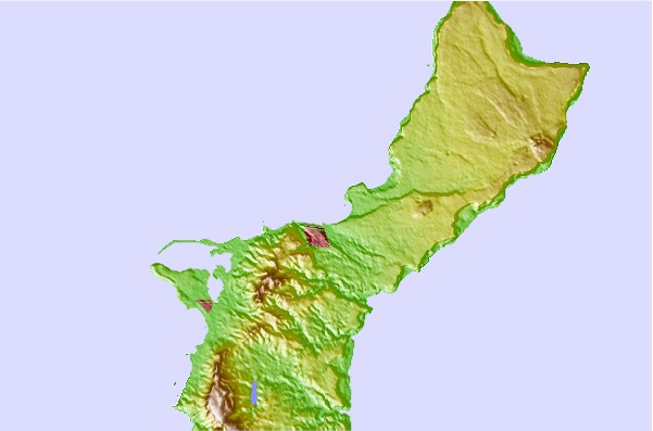
Utilisez cette carte en relief pour naviguer vers les spots de surf de Guam, et les stations de marées aux alentours de Boat Basin Rights
Spots de Surf les plus proches de Boat Basin Rights:
(Cliquez sur le nom du spot pour plus de détails)- Closest spot0 mi
- Second closest spot1 mi
- Third closest spot1 mi
- Fourth closest spot2 mi
- Fifth closest spot4 mi
Bouées marines les plus proches de Boat Basin Rights:
- Closest Bouées marines9 mi
- Second closest Bouées marines14 mi
- Third closest Bouées marines137 mi
- Fourth closest Bouées marines745 mi
- Fifth closest Bouées marines1400 mi
Stations de marée les plus proches de Boat Basin Rights:
- Closest station de maréeTamuning2 mi
- Second closest station de maréePago Bay5 mi
- Third closest station de maréeDededo6 mi
- Fourth closest station de maréeApra Harbor7 mi
- Fifth closest station de maréeYigo9 mi
Airports
- The closest passenger airport to Boat Basin Rights is Guam International (Agana) Airport (GUM) in Mariana Islands, 5 km (3 miles) away (directly).
- The second nearest airport to Boat Basin Rights is Andersen Afb Airport (UAM), also in Mariana Islands, 22 km (14 miles) away.
- Third is Rota International Airport (ROP) in Mariana Islands, 93 km (58 miles) away.
- West Tinian Airport (TNI) in Mariana Islands is 193 km (120 miles) away.
- Saipan International Airport (SPN), also in Mariana Islands is the fifth nearest airport to Boat Basin Rights and is 210 km (130 miles) away.

- /breaks/Boat-Basin-Rights/forecasts/latest


 Nearest