
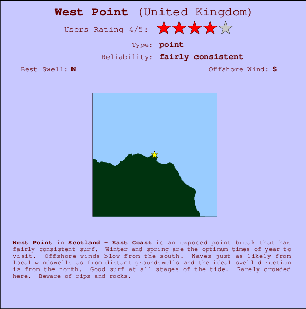
West Point Surf Guide
West Point on the East Coast is an exposed point break that has fairly consistent surf. Winter and spring are the optimum times of year to visit. The best wind direction is from the south. Groundswells and windswells are equally likely and the ideal swell angle is from the north. Surfable at all stages of the tide. It very rarely gets crowded here. Beware of rips and rocks.
West Point Spot Info
| Type: | Rating: | Reliability: | Todays Sea Temp*: |
|---|---|---|---|
| fairly consistent | 14.6°C*ocean temperature recorded from satellite |
Surfing West Point:
The best conditions reported for surf at West Point occur when a North swell combines with an offshore wind direction from the South.
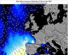
Énergie de Vague (puissance): 12h


West Point Surf:
Thursday, 16 July 2026, 06:39 Local time| Mer | Jeudi 16 | |||
| 10PM | 1AM | 4AM | 7AM | |
| Wave (m) | ||||
| Période (s) | 6 | 6 | 6 | 5 |
| Vent (km/h) | ||||
| Etat du vent | cross- off |
off | off | glass |
- /breaks/West-Point/forecasts/latest
West Point Surf Guide
West Point on the East Coast is an exposed point break that has fairly consistent surf. Winter and spring are the optimum times of year to visit. The best wind direction is from the south. Groundswells and windswells are equally likely and the ideal swell angle is from the north. Surfable at all stages of the tide. It very rarely gets crowded here. Beware of rips and rocks.
West Point Spot Info
Type: Rating: Reliability: Todays Sea Temp*:  Point
Point 4
4fairly consistent 14.6°C*ocean temperature recorded from satelliteSurfing West Point:
The best conditions reported for surf at West Point occur when a North swell combines with an offshore wind direction from the South.
Énergie de Vague (puissance): 12h
Utilisez les onglets ci-dessus pour voir la température de la mer à West Point, photos pour West Point, prévisions de houle détaillées pour West Point, prévisions de vent et météo, webcams pour West Point, conditions de vents en temps réel à partir des données de la station météo de Scot - East Coast et prévisions des marées pour West Point. Les cartes de houle pour United Kingdom afficheront une image agrandie de United Kingdom et des ses mers environnantes. Ces cartes de houles peuvent êtres animées pour montrer les différents composantes de houle, la hauteur, la période et l'énergie des vagues avec les prévisions météo et prévisions de vent. Des observations en temps réel du temps et de l'état de la mer sont fournies grâce aux bouées marines de United Kingdom, des navires de passages, et des stations météo côtières. Toutes les pages de prévisions pour ce spot de surf ont un Vagu-o-Mètre Local et Global pour facilement trouver les meilleurs spot de surf à proximité de West Point.
West Point Surf:
Thursday, 16 July 2026, 06:39 Local timeMer Jeudi 16 10PM 1AM 4AM 7AM Wave (m) Période (s) 6 6 6 5 Vent (km/h) Etat du vent cross-
offoff off glass - /breaks/West-Point/forecasts/latest
- /breaks/West-Point/forecasts/latest/six_day
West Point Surf Guide
West Point on the East Coast is an exposed point break that has fairly consistent surf. Winter and spring are the optimum times of year to visit. The best wind direction is from the south. Groundswells and windswells are equally likely and the ideal swell angle is from the north. Surfable at all stages of the tide. It very rarely gets crowded here. Beware of rips and rocks.
West Point Spot Info
Type: Rating: Reliability: Todays Sea Temp*: Point4fairly consistent 14.6°C*ocean temperature recorded from satelliteSurfing West Point:
The best conditions reported for surf at West Point occur when a North swell combines with an offshore wind direction from the South.
Énergie de Vague (puissance): 12h
Utilisez les onglets ci-dessus pour voir la température de la mer à West Point, photos pour West Point, prévisions de houle détaillées pour West Point, prévisions de vent et météo, webcams pour West Point, conditions de vents en temps réel à partir des données de la station météo de Scot - East Coast et prévisions des marées pour West Point. Les cartes de houle pour United Kingdom afficheront une image agrandie de United Kingdom et des ses mers environnantes. Ces cartes de houles peuvent êtres animées pour montrer les différents composantes de houle, la hauteur, la période et l'énergie des vagues avec les prévisions météo et prévisions de vent. Des observations en temps réel du temps et de l'état de la mer sont fournies grâce aux bouées marines de United Kingdom, des navires de passages, et des stations météo côtières. Toutes les pages de prévisions pour ce spot de surf ont un Vagu-o-Mètre Local et Global pour facilement trouver les meilleurs spot de surf à proximité de West Point.
West Point Surf:
Thursday, 16 July 2026, 06:39 Local timeMer Jeudi 16 10PM 1AM 4AM 7AM Wave (m) Période (s) 6 6 6 5 Vent (km/h) Etat du vent cross-
offoff off glass - /breaks/West-Point/forecasts/latest
West Point Surf Guide
West Point on the East Coast is an exposed point break that has fairly consistent surf. Winter and spring are the optimum times of year to visit. The best wind direction is from the south. Groundswells and windswells are equally likely and the ideal swell angle is from the north. Surfable at all stages of the tide. It very rarely gets crowded here. Beware of rips and rocks.
West Point Spot Info
Type: Rating: Reliability: Todays Sea Temp*: Point4fairly consistent 14.6°C*ocean temperature recorded from satelliteSurfing West Point:
The best conditions reported for surf at West Point occur when a North swell combines with an offshore wind direction from the South.
Énergie de Vague (puissance): 12h
Utilisez les onglets ci-dessus pour voir la température de la mer à West Point, photos pour West Point, prévisions de houle détaillées pour West Point, prévisions de vent et météo, webcams pour West Point, conditions de vents en temps réel à partir des données de la station météo de Scot - East Coast et prévisions des marées pour West Point. Les cartes de houle pour United Kingdom afficheront une image agrandie de United Kingdom et des ses mers environnantes. Ces cartes de houles peuvent êtres animées pour montrer les différents composantes de houle, la hauteur, la période et l'énergie des vagues avec les prévisions météo et prévisions de vent. Des observations en temps réel du temps et de l'état de la mer sont fournies grâce aux bouées marines de United Kingdom, des navires de passages, et des stations météo côtières. Toutes les pages de prévisions pour ce spot de surf ont un Vagu-o-Mètre Local et Global pour facilement trouver les meilleurs spot de surf à proximité de West Point.
West Point Surf:
Thursday, 16 July 2026, 06:39 Local timeMer Jeudi 16 10PM 1AM 4AM 7AM Wave (m) Période (s) 6 6 6 5 Vent (km/h) Etat du vent cross-
offoff off glass Tide Times:
À Fraserburgh (0 km).
PROCHAIN EST A (heure locale) il reste marée haute marée basse West Point Tide Times and Tide Chart
Live Weather:
At SHIP3089, 18 km from West Point.
- Air temperature
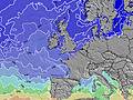
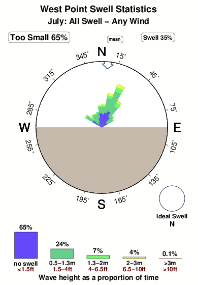
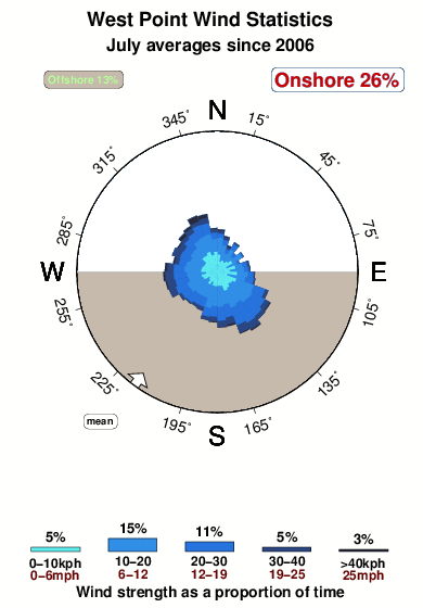
12.0°COverall West Point Surf Consistency and Wind Distribution in Juillet
Photos de Surf
de la galerieContours: Routes et Rivières: Sélectionnez un spot de surf du menu 
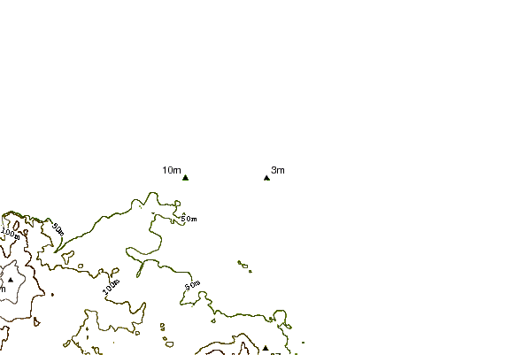

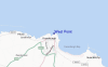
Utilisez cette carte en relief pour naviguer vers les spots de surf de Scot - East Coast, et les stations de marées aux alentours de West Point
Spots de Surf les plus proches de West Point:
(Cliquez sur le nom du spot pour plus de détails)- Closest spot1 mi
- Second closest spot1 mi
- Third closest spot2 mi
- Fourth closest spot2 mi
- Fifth closest spot4 mi
Bouées marines les plus proches de West Point:
- Closest Bouées marines52 mi
- Second closest Bouées marines79 mi
- Third closest Bouées marines93 mi
- Fourth closest Bouées marines99 mi
- Fifth closest Bouées marines99 mi
Stations de marée les plus proches de West Point:
- Closest station de maréeFraserburgh0 mi
- Second closest station de maréePeterhead16 mi
- Third closest station de maréeBuckie35 mi
- Fourth closest station de maréeAberdeen39 mi
- Fifth closest station de maréePortlethen45 mi
Airports
- The closest passenger airport to West Point is Dyce (Aberdeen) Airport (ABZ) in U.k, 56 km (35 miles) away (directly).
- The second nearest airport to West Point is Lossiemouth Airport (LMO), also in U.k, 79 km (49 miles) away.
- Third is Wick Airport (WIC) in U.k., 106 km (66 miles) away.
- Inverness Airport (INV) in U.k is 123 km (76 miles) away.
- Kirkwall Airport (KOI) in Scotland is the fifth nearest airport to West Point and is 150 km (93 miles) away.
- /breaks/West-Point/forecasts/latest


 Nearest