

San Onofre - Trails Surf Guide
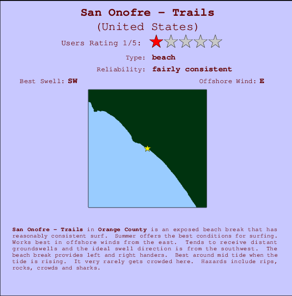
Trails - San Onofre State Beach in San Diego County is an exposed beach break that has reasonably consistent surf. Summer offers the best conditions for surfing. Ideal winds are from the east. Tends to receive distant groundswells and the ideal swell direction is from the southwest. Waves at the beach are both lefts and rights. Best around mid tide when the tide is rising. Even when there are waves, it's not likley to be crowded. Hazards include .
San Onofre - Trails Spot Info
| Type: | Rating: | Reliability: | Todays Sea Temp*: |
|---|---|---|---|
| fairly consistent | 22.9°C*ocean temperature recorded from satellite |
Surfing San Onofre - Trails:
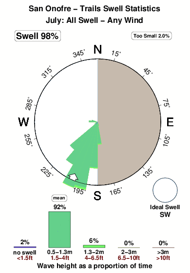
The best conditions reported for surf at San Onofre - Trails occur when a Southwest swell combines with an offshore wind direction from the East.

Énergie de Vague (puissance): 12h


San Onofre - Trails Surf:
Tuesday, 28 July 2026, 08:31 Local time| Mardi 28 | ||||
| 8AM | 11AM | 2PM | 5PM | |
| Wave (m) | ||||
| Période (s) | 17 | 17 | 17 | 17 |
| Vent (km/h) | ||||
| Etat du vent | cross- off |
cross | cross- on |
cross- on |
- /breaks/Trails-San-Onofre-State-Beach/forecasts/latest
San Onofre - Trails Surf Guide
Trails - San Onofre State Beach in San Diego County is an exposed beach break that has reasonably consistent surf. Summer offers the best conditions for surfing. Ideal winds are from the east. Tends to receive distant groundswells and the ideal swell direction is from the southwest. Waves at the beach are both lefts and rights. Best around mid tide when the tide is rising. Even when there are waves, it's not likley to be crowded. Hazards include .
San Onofre - Trails Spot Info
Type: Rating: Reliability: Todays Sea Temp*:  Beach
Beach 1
1fairly consistent 22.9°C*ocean temperature recorded from satelliteSurfing San Onofre - Trails:
The best conditions reported for surf at San Onofre - Trails occur when a Southwest swell combines with an offshore wind direction from the East.
Énergie de Vague (puissance): 12h
Utilisez les onglets ci-dessus pour voir la température de la mer à San Onofre - Trails, photos pour San Onofre - Trails, prévisions de houle détaillées pour San Onofre - Trails, prévisions de vent et météo, webcams pour San Onofre - Trails, conditions de vents en temps réel à partir des données de la station météo de CAL - Orange County et prévisions des marées pour San Onofre - Trails. Les cartes de houle pour United States afficheront une image agrandie de United States et des ses mers environnantes. Ces cartes de houles peuvent êtres animées pour montrer les différents composantes de houle, la hauteur, la période et l'énergie des vagues avec les prévisions météo et prévisions de vent. Des observations en temps réel du temps et de l'état de la mer sont fournies grâce aux bouées marines de United States, des navires de passages, et des stations météo côtières. Toutes les pages de prévisions pour ce spot de surf ont un Vagu-o-Mètre Local et Global pour facilement trouver les meilleurs spot de surf à proximité de San Onofre - Trails.
San Onofre - Trails Surf:
Tuesday, 28 July 2026, 08:31 Local timeMardi 28 8AM 11AM 2PM 5PM Wave (m) Période (s) 17 17 17 17 Vent (km/h) Etat du vent cross-
offcross cross-
oncross-
on- /breaks/Trails-San-Onofre-State-Beach/forecasts/latest
- /breaks/Trails-San-Onofre-State-Beach/forecasts/latest/six_day
San Onofre - Trails Surf Guide
Trails - San Onofre State Beach in San Diego County is an exposed beach break that has reasonably consistent surf. Summer offers the best conditions for surfing. Ideal winds are from the east. Tends to receive distant groundswells and the ideal swell direction is from the southwest. Waves at the beach are both lefts and rights. Best around mid tide when the tide is rising. Even when there are waves, it's not likley to be crowded. Hazards include .
San Onofre - Trails Spot Info
Type: Rating: Reliability: Todays Sea Temp*: Beach1fairly consistent 22.9°C*ocean temperature recorded from satelliteSurfing San Onofre - Trails:
The best conditions reported for surf at San Onofre - Trails occur when a Southwest swell combines with an offshore wind direction from the East.
Énergie de Vague (puissance): 12h
Utilisez les onglets ci-dessus pour voir la température de la mer à San Onofre - Trails, photos pour San Onofre - Trails, prévisions de houle détaillées pour San Onofre - Trails, prévisions de vent et météo, webcams pour San Onofre - Trails, conditions de vents en temps réel à partir des données de la station météo de CAL - Orange County et prévisions des marées pour San Onofre - Trails. Les cartes de houle pour United States afficheront une image agrandie de United States et des ses mers environnantes. Ces cartes de houles peuvent êtres animées pour montrer les différents composantes de houle, la hauteur, la période et l'énergie des vagues avec les prévisions météo et prévisions de vent. Des observations en temps réel du temps et de l'état de la mer sont fournies grâce aux bouées marines de United States, des navires de passages, et des stations météo côtières. Toutes les pages de prévisions pour ce spot de surf ont un Vagu-o-Mètre Local et Global pour facilement trouver les meilleurs spot de surf à proximité de San Onofre - Trails.
San Onofre - Trails Surf:
Tuesday, 28 July 2026, 08:31 Local timeMardi 28 8AM 11AM 2PM 5PM Wave (m) Période (s) 17 17 17 17 Vent (km/h) Etat du vent cross-
offcross cross-
oncross-
on- /breaks/Trails-San-Onofre-State-Beach/forecasts/latest
San Onofre - Trails Surf Guide
Trails - San Onofre State Beach in San Diego County is an exposed beach break that has reasonably consistent surf. Summer offers the best conditions for surfing. Ideal winds are from the east. Tends to receive distant groundswells and the ideal swell direction is from the southwest. Waves at the beach are both lefts and rights. Best around mid tide when the tide is rising. Even when there are waves, it's not likley to be crowded. Hazards include .
San Onofre - Trails Spot Info
Type: Rating: Reliability: Todays Sea Temp*: Beach1fairly consistent 22.9°C*ocean temperature recorded from satelliteSurfing San Onofre - Trails:
The best conditions reported for surf at San Onofre - Trails occur when a Southwest swell combines with an offshore wind direction from the East.
Énergie de Vague (puissance): 12h
Utilisez les onglets ci-dessus pour voir la température de la mer à San Onofre - Trails, photos pour San Onofre - Trails, prévisions de houle détaillées pour San Onofre - Trails, prévisions de vent et météo, webcams pour San Onofre - Trails, conditions de vents en temps réel à partir des données de la station météo de CAL - Orange County et prévisions des marées pour San Onofre - Trails. Les cartes de houle pour United States afficheront une image agrandie de United States et des ses mers environnantes. Ces cartes de houles peuvent êtres animées pour montrer les différents composantes de houle, la hauteur, la période et l'énergie des vagues avec les prévisions météo et prévisions de vent. Des observations en temps réel du temps et de l'état de la mer sont fournies grâce aux bouées marines de United States, des navires de passages, et des stations météo côtières. Toutes les pages de prévisions pour ce spot de surf ont un Vagu-o-Mètre Local et Global pour facilement trouver les meilleurs spot de surf à proximité de San Onofre - Trails.
San Onofre - Trails Surf:
Tuesday, 28 July 2026, 08:31 Local timeMardi 28 8AM 11AM 2PM 5PM Wave (m) Période (s) 17 17 17 17 Vent (km/h) Etat du vent cross-
offcross cross-
oncross-
onTide Times:
Pour San Clemente, California, %{dist} %{km} de %{location}.
PROCHAIN EST A (heure locale) il reste marée haute marée basse San Onofre - Trails Tide Times and Tide Chart
Live Weather:
At BUOY-46275, 10 km from San Onofre - Trails.
- Air temperature
20.8°COverall San Onofre - Trails Surf Consistency and Wind Distribution in Juillet
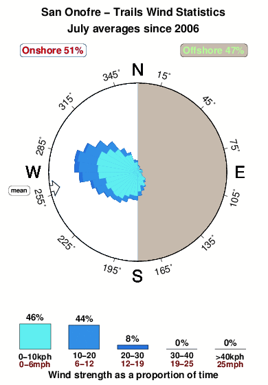


Wind stats for San Onofre - Trails: see the variation in direction and stength by month.
Photos de Surf
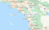
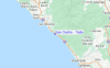
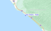
de la galerieContours: Routes et Rivières: Sélectionnez un spot de surf du menu 


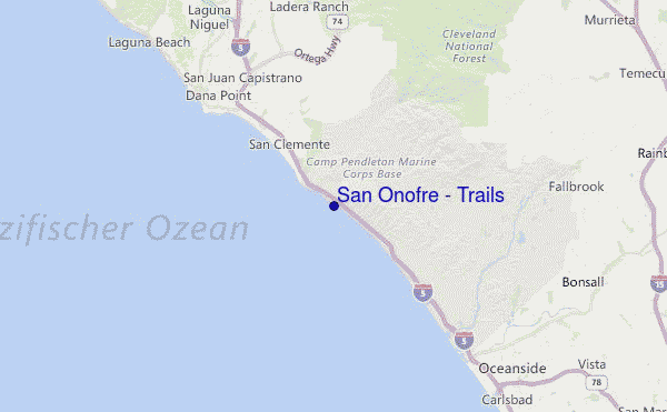
Utilisez cette carte en relief pour naviguer vers les spots de surf de CAL - Orange County, et les stations de marées aux alentours de San Onofre - Trails
Spots de Surf les plus proches de San Onofre - Trails:
(Cliquez sur le nom du spot pour plus de détails)- Closest spot1 mi
- Second closest spot1 mi
- Third closest spot2 mi
- Fourth closest spot2 mi
- Fifth closest spot3 mi
Bouées marines les plus proches de San Onofre - Trails:
- Closest Bouées marines12 mi
- Second closest Bouées marines14 mi
- Third closest Bouées marines32 mi
- Fourth closest Bouées marines38 mi
- Fifth closest Bouées marines39 mi
Stations de marée les plus proches de San Onofre - Trails:
- Closest station de maréeSan Clemente5 mi
- Second closest station de maréeDana Point11 mi
- Third closest station de maréeLaguna Niguel14 mi
- Fourth closest station de maréeOceanside16 mi
- Fifth closest station de maréeLaguna Beach18 mi
Airports
- The closest passenger airport to San Onofre - Trails is John Wayne Arpt Orange Co (Santa Ana) Airport (SNA) in USA, 45 km (28 miles) away (directly).
- The second nearest airport to San Onofre - Trails is Tustin Mcaf Airport (NTK), also in USA, 46 km (29 miles) away.
- Third is March Arb (Riverside) Airport (RIV) in USA, 64 km (40 miles) away.
- Riverside Muni Airport (RAL) in USA is 66 km (41 miles) away.
- Miramar Mcas Airport (NKX), also in USA is the fifth nearest airport to San Onofre - Trails and is 67 km (42 miles) away.
- /breaks/Trails-San-Onofre-State-Beach/forecasts/latest
 Nearest