

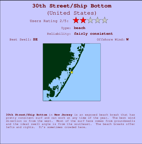
30th Street/Ship Bottom Surf Guide
30th Street/Ship Bottom in New Jersey is an exposed beach break that has fairly consistent surf and can work at any time of the year. Offshore winds are from the west. Most of the surf here comes from groundswells and the best swell direction is from the southeast. Waves at the beach break both left and right. When it's working here, it can get crowded.
30th Street/Ship Bottom Spot Info
| Type: | Rating: | Reliability: | Todays Sea Temp*: |
|---|---|---|---|
| fairly consistent | 25.0°C*ocean temperature recorded from satellite |
Surfing 30th Street/Ship Bottom:
The best conditions reported for surf at 30th Street/Ship Bottom occur when a Southeast swell combines with an offshore wind direction from the West.

Énergie de Vague (puissance): 12h


30th Street/Ship Bottom Surf:
Saturday, 18 July 2026, 09:01 Local time| Samedi 18 | ||||
| 5AM | 8AM | 11AM | 2PM | |
| Wave (m) | ||||
| Période (s) | 14 | 14 | 14 | 13 |
| Vent (km/h) | ||||
| Etat du vent | cross- off |
cross- off |
cross- off |
cross |
- /breaks/Thirtith-Street/forecasts/latest
30th Street/Ship Bottom Surf Guide
30th Street/Ship Bottom in New Jersey is an exposed beach break that has fairly consistent surf and can work at any time of the year. Offshore winds are from the west. Most of the surf here comes from groundswells and the best swell direction is from the southeast. Waves at the beach break both left and right. When it's working here, it can get crowded.
30th Street/Ship Bottom Spot Info
Type: Rating: Reliability: Todays Sea Temp*:  Beach
Beach 2
2fairly consistent 25.0°C*ocean temperature recorded from satelliteSurfing 30th Street/Ship Bottom:
The best conditions reported for surf at 30th Street/Ship Bottom occur when a Southeast swell combines with an offshore wind direction from the West.
Énergie de Vague (puissance): 12h
Utilisez les onglets ci-dessus pour voir la température de la mer à 30th Street/Ship Bottom, photos pour 30th Street/Ship Bottom, prévisions de houle détaillées pour 30th Street/Ship Bottom, prévisions de vent et météo, webcams pour 30th Street/Ship Bottom, conditions de vents en temps réel à partir des données de la station météo de New Jersey et prévisions des marées pour 30th Street/Ship Bottom. Les cartes de houle pour United States afficheront une image agrandie de United States et des ses mers environnantes. Ces cartes de houles peuvent êtres animées pour montrer les différents composantes de houle, la hauteur, la période et l'énergie des vagues avec les prévisions météo et prévisions de vent. Des observations en temps réel du temps et de l'état de la mer sont fournies grâce aux bouées marines de United States, des navires de passages, et des stations météo côtières. Toutes les pages de prévisions pour ce spot de surf ont un Vagu-o-Mètre Local et Global pour facilement trouver les meilleurs spot de surf à proximité de 30th Street/Ship Bottom.
30th Street/Ship Bottom Surf:
Saturday, 18 July 2026, 09:01 Local timeSamedi 18 5AM 8AM 11AM 2PM Wave (m) Période (s) 14 14 14 13 Vent (km/h) Etat du vent cross-
offcross-
offcross-
offcross - /breaks/Thirtith-Street/forecasts/latest
- /breaks/Thirtith-Street/forecasts/latest/six_day
30th Street/Ship Bottom Surf Guide
30th Street/Ship Bottom in New Jersey is an exposed beach break that has fairly consistent surf and can work at any time of the year. Offshore winds are from the west. Most of the surf here comes from groundswells and the best swell direction is from the southeast. Waves at the beach break both left and right. When it's working here, it can get crowded.
30th Street/Ship Bottom Spot Info
Type: Rating: Reliability: Todays Sea Temp*: Beach2fairly consistent 25.0°C*ocean temperature recorded from satelliteSurfing 30th Street/Ship Bottom:
The best conditions reported for surf at 30th Street/Ship Bottom occur when a Southeast swell combines with an offshore wind direction from the West.
Énergie de Vague (puissance): 12h
Utilisez les onglets ci-dessus pour voir la température de la mer à 30th Street/Ship Bottom, photos pour 30th Street/Ship Bottom, prévisions de houle détaillées pour 30th Street/Ship Bottom, prévisions de vent et météo, webcams pour 30th Street/Ship Bottom, conditions de vents en temps réel à partir des données de la station météo de New Jersey et prévisions des marées pour 30th Street/Ship Bottom. Les cartes de houle pour United States afficheront une image agrandie de United States et des ses mers environnantes. Ces cartes de houles peuvent êtres animées pour montrer les différents composantes de houle, la hauteur, la période et l'énergie des vagues avec les prévisions météo et prévisions de vent. Des observations en temps réel du temps et de l'état de la mer sont fournies grâce aux bouées marines de United States, des navires de passages, et des stations météo côtières. Toutes les pages de prévisions pour ce spot de surf ont un Vagu-o-Mètre Local et Global pour facilement trouver les meilleurs spot de surf à proximité de 30th Street/Ship Bottom.
30th Street/Ship Bottom Surf:
Saturday, 18 July 2026, 09:01 Local timeSamedi 18 5AM 8AM 11AM 2PM Wave (m) Période (s) 14 14 14 13 Vent (km/h) Etat du vent cross-
offcross-
offcross-
offcross - /breaks/Thirtith-Street/forecasts/latest
30th Street/Ship Bottom Surf Guide
30th Street/Ship Bottom in New Jersey is an exposed beach break that has fairly consistent surf and can work at any time of the year. Offshore winds are from the west. Most of the surf here comes from groundswells and the best swell direction is from the southeast. Waves at the beach break both left and right. When it's working here, it can get crowded.
30th Street/Ship Bottom Spot Info
Type: Rating: Reliability: Todays Sea Temp*: Beach2fairly consistent 25.0°C*ocean temperature recorded from satelliteSurfing 30th Street/Ship Bottom:
The best conditions reported for surf at 30th Street/Ship Bottom occur when a Southeast swell combines with an offshore wind direction from the West.
Énergie de Vague (puissance): 12h
Utilisez les onglets ci-dessus pour voir la température de la mer à 30th Street/Ship Bottom, photos pour 30th Street/Ship Bottom, prévisions de houle détaillées pour 30th Street/Ship Bottom, prévisions de vent et météo, webcams pour 30th Street/Ship Bottom, conditions de vents en temps réel à partir des données de la station météo de New Jersey et prévisions des marées pour 30th Street/Ship Bottom. Les cartes de houle pour United States afficheront une image agrandie de United States et des ses mers environnantes. Ces cartes de houles peuvent êtres animées pour montrer les différents composantes de houle, la hauteur, la période et l'énergie des vagues avec les prévisions météo et prévisions de vent. Des observations en temps réel du temps et de l'état de la mer sont fournies grâce aux bouées marines de United States, des navires de passages, et des stations météo côtières. Toutes les pages de prévisions pour ce spot de surf ont un Vagu-o-Mètre Local et Global pour facilement trouver les meilleurs spot de surf à proximité de 30th Street/Ship Bottom.
30th Street/Ship Bottom Surf:
Saturday, 18 July 2026, 09:01 Local timeSamedi 18 5AM 8AM 11AM 2PM Wave (m) Période (s) 14 14 14 13 Vent (km/h) Etat du vent cross-
offcross-
offcross-
offcross Tide Times:
Pour Seaside Heights, ocean, New Jersey, %{dist} %{km} de %{location}.
PROCHAIN EST A (heure locale) il reste marée haute marée basse 30th Street/Ship Bottom Tide Times and Tide Chart
Live Weather:
At BUOY-JCRN4, 26 km from 30th Street/Ship Bottom.
calm
(km/h)Air temperature
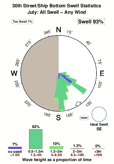
22.9°COverall 30th Street/Ship Bottom Surf Consistency and Wind Distribution in Juillet
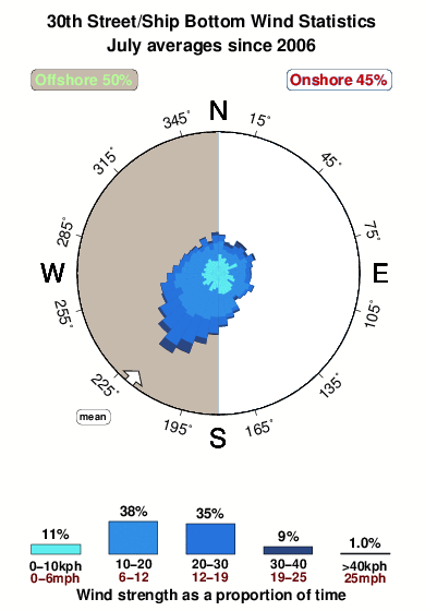


Wind stats for 30th Street/Ship Bottom: see the variation in direction and stength by month.
Photos de Surf
de la galerieContours: Routes et Rivières: Sélectionnez un spot de surf du menu 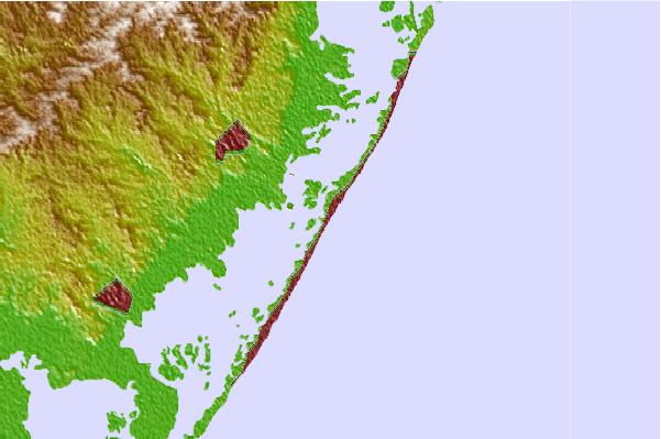
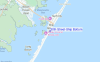
Utilisez cette carte en relief pour naviguer vers les spots de surf de New Jersey, et les stations de marées aux alentours de 30th Street/Ship Bottom
Spots de Surf les plus proches de 30th Street/Ship Bottom:
(Cliquez sur le nom du spot pour plus de détails)- Closest spot1 mi
- Second closest spot2 mi
- Third closest spot2 mi
- Fourth closest spot4 mi
- Fifth closest spot4 mi
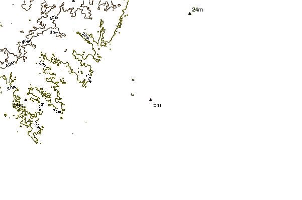
Bouées marines les plus proches de 30th Street/Ship Bottom:
- Closest Bouées marines2 mi
- Second closest Bouées marines24 mi
- Third closest Bouées marines57 mi
- Fourth closest Bouées marines68 mi
- Fifth closest Bouées marines85 mi
Stations de marée les plus proches de 30th Street/Ship Bottom:
- Closest station de maréeManahawkin Drawbridge, Manahawkin Bay1 mi
- Second closest station de maréeBeach Haven Crest2 mi
- Third closest station de maréeManahawkin Creek, Manahawkin Bay2 mi
- Fourth closest station de maréeMill Creek, 1 nautical miles above entrance3 mi
- Fifth closest station de maréeNorth Beach, Manahawkin Bay3 mi
Airports
- The closest passenger airport to 30th Street/Ship Bottom is Atlantic City International Airport (ACY) in USA, 39 km (24 miles) away (directly).
- The second nearest airport to 30th Street/Ship Bottom is Lakehurst Naes Airport (NEL), also in USA, 46 km (29 miles) away.
- Third is Mc Guire Afb (Wrightstown) Airport (WRI) in USA, 55 km (34 miles) away.
- Millville Muni Airport (MIV) in USA is 82 km (51 miles) away.
- Northeast Philadelphia Airport (PNE), also in USA is the fifth nearest airport to 30th Street/Ship Bottom and is 86 km (53 miles) away.
- /breaks/Thirtith-Street/forecasts/latest

 Nearest