

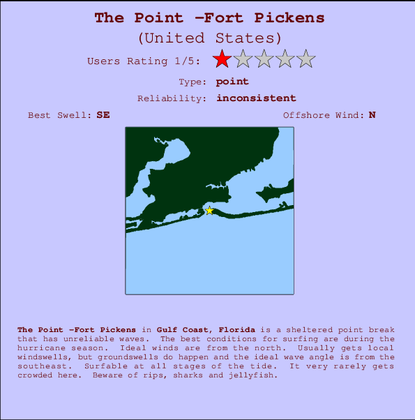
The Point -Fort Pickens Surf Guide
The Point -Fort Pickens in Florida is a sheltered point break that only works once in a while. The best conditions for surfing are during the hurricane season. The best wind direction is from the north. Waves more likely to be from local windswells than distant groundswells and the ideal wave direction is from the southeast.The waves is a point break that peels left. Good surf at all stages of the tide. Rarely crowded here. Hazards include rips, sharks and jellyfish.
The Point -Fort Pickens Spot Info
| Type: | Rating: | Reliability: | Todays Sea Temp*: |
|---|---|---|---|
| inconsistent | 30.7°C*ocean temperature recorded from satellite |
Surfing The Point -Fort Pickens:
The best conditions reported for surf at The Point -Fort Pickens occur when a Southeast swell combines with an offshore wind direction from the North.
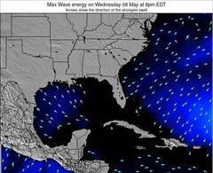
Énergie de Vague (puissance): 12h

The Point -Fort Pickens Surf:
Tuesday, 14 July 2026, 05:06 Local time| Mardi 14 | ||||
| 4AM | 7AM | 10AM | 1PM | |
| Wave (m) | ||||
| Période (s) | 4 | 4 | 4 | 4 |
| Vent (km/h) | ||||
| Etat du vent | cross- off |
cross | cross- off |
cross |
- /breaks/The-Point_Fort-Pickens/forecasts/latest
The Point -Fort Pickens Surf Guide
The Point -Fort Pickens in Florida is a sheltered point break that only works once in a while. The best conditions for surfing are during the hurricane season. The best wind direction is from the north. Waves more likely to be from local windswells than distant groundswells and the ideal wave direction is from the southeast.The waves is a point break that peels left. Good surf at all stages of the tide. Rarely crowded here. Hazards include rips, sharks and jellyfish.
The Point -Fort Pickens Spot Info
Type: Rating: Reliability: Todays Sea Temp*:  Point
Point 1
1inconsistent 30.7°C*ocean temperature recorded from satelliteSurfing The Point -Fort Pickens:
The best conditions reported for surf at The Point -Fort Pickens occur when a Southeast swell combines with an offshore wind direction from the North.
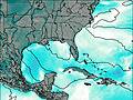
Énergie de Vague (puissance): 12h
Utilisez les onglets ci-dessus pour voir la température de la mer à The Point -Fort Pickens, photos pour The Point -Fort Pickens, prévisions de houle détaillées pour The Point -Fort Pickens, prévisions de vent et météo, webcams pour The Point -Fort Pickens, conditions de vents en temps réel à partir des données de la station météo de Florida - Gulf et prévisions des marées pour The Point -Fort Pickens. Les cartes de houle pour United States afficheront une image agrandie de United States et des ses mers environnantes. Ces cartes de houles peuvent êtres animées pour montrer les différents composantes de houle, la hauteur, la période et l'énergie des vagues avec les prévisions météo et prévisions de vent. Des observations en temps réel du temps et de l'état de la mer sont fournies grâce aux bouées marines de United States, des navires de passages, et des stations météo côtières. Toutes les pages de prévisions pour ce spot de surf ont un Vagu-o-Mètre Local et Global pour facilement trouver les meilleurs spot de surf à proximité de The Point -Fort Pickens.
The Point -Fort Pickens Surf:
Tuesday, 14 July 2026, 05:06 Local timeMardi 14 4AM 7AM 10AM 1PM Wave (m) Période (s) 4 4 4 4 Vent (km/h) Etat du vent cross-
offcross cross-
offcross - /breaks/The-Point_Fort-Pickens/forecasts/latest
- /breaks/The-Point_Fort-Pickens/forecasts/latest/six_day
The Point -Fort Pickens Surf Guide
The Point -Fort Pickens in Florida is a sheltered point break that only works once in a while. The best conditions for surfing are during the hurricane season. The best wind direction is from the north. Waves more likely to be from local windswells than distant groundswells and the ideal wave direction is from the southeast.The waves is a point break that peels left. Good surf at all stages of the tide. Rarely crowded here. Hazards include rips, sharks and jellyfish.
The Point -Fort Pickens Spot Info
Type: Rating: Reliability: Todays Sea Temp*: Point1inconsistent 30.7°C*ocean temperature recorded from satelliteSurfing The Point -Fort Pickens:
The best conditions reported for surf at The Point -Fort Pickens occur when a Southeast swell combines with an offshore wind direction from the North.
Énergie de Vague (puissance): 12h
Utilisez les onglets ci-dessus pour voir la température de la mer à The Point -Fort Pickens, photos pour The Point -Fort Pickens, prévisions de houle détaillées pour The Point -Fort Pickens, prévisions de vent et météo, webcams pour The Point -Fort Pickens, conditions de vents en temps réel à partir des données de la station météo de Florida - Gulf et prévisions des marées pour The Point -Fort Pickens. Les cartes de houle pour United States afficheront une image agrandie de United States et des ses mers environnantes. Ces cartes de houles peuvent êtres animées pour montrer les différents composantes de houle, la hauteur, la période et l'énergie des vagues avec les prévisions météo et prévisions de vent. Des observations en temps réel du temps et de l'état de la mer sont fournies grâce aux bouées marines de United States, des navires de passages, et des stations météo côtières. Toutes les pages de prévisions pour ce spot de surf ont un Vagu-o-Mètre Local et Global pour facilement trouver les meilleurs spot de surf à proximité de The Point -Fort Pickens.
The Point -Fort Pickens Surf:
Tuesday, 14 July 2026, 05:06 Local timeMardi 14 4AM 7AM 10AM 1PM Wave (m) Période (s) 4 4 4 4 Vent (km/h) Etat du vent cross-
offcross cross-
offcross - /breaks/The-Point_Fort-Pickens/forecasts/latest
The Point -Fort Pickens Surf Guide
The Point -Fort Pickens in Florida is a sheltered point break that only works once in a while. The best conditions for surfing are during the hurricane season. The best wind direction is from the north. Waves more likely to be from local windswells than distant groundswells and the ideal wave direction is from the southeast.The waves is a point break that peels left. Good surf at all stages of the tide. Rarely crowded here. Hazards include rips, sharks and jellyfish.
The Point -Fort Pickens Spot Info
Type: Rating: Reliability: Todays Sea Temp*: Point1inconsistent 30.7°C*ocean temperature recorded from satelliteSurfing The Point -Fort Pickens:
The best conditions reported for surf at The Point -Fort Pickens occur when a Southeast swell combines with an offshore wind direction from the North.
Énergie de Vague (puissance): 12h
Utilisez les onglets ci-dessus pour voir la température de la mer à The Point -Fort Pickens, photos pour The Point -Fort Pickens, prévisions de houle détaillées pour The Point -Fort Pickens, prévisions de vent et météo, webcams pour The Point -Fort Pickens, conditions de vents en temps réel à partir des données de la station météo de Florida - Gulf et prévisions des marées pour The Point -Fort Pickens. Les cartes de houle pour United States afficheront une image agrandie de United States et des ses mers environnantes. Ces cartes de houles peuvent êtres animées pour montrer les différents composantes de houle, la hauteur, la période et l'énergie des vagues avec les prévisions météo et prévisions de vent. Des observations en temps réel du temps et de l'état de la mer sont fournies grâce aux bouées marines de United States, des navires de passages, et des stations météo côtières. Toutes les pages de prévisions pour ce spot de surf ont un Vagu-o-Mètre Local et Global pour facilement trouver les meilleurs spot de surf à proximité de The Point -Fort Pickens.
The Point -Fort Pickens Surf:
Tuesday, 14 July 2026, 05:06 Local timeMardi 14 4AM 7AM 10AM 1PM Wave (m) Période (s) 4 4 4 4 Vent (km/h) Etat du vent cross-
offcross cross-
offcross Tide Times:
Pour Pensacola Bay Entrance, Pensacola Bay, Florida, %{dist} %{km} de %{location}.
PROCHAIN EST A (heure locale) il reste marée haute marée basse The Point -Fort Pickens Tide Times and Tide Chart
Live Weather:
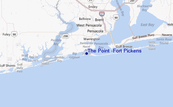
At Pensacola Airport, 3 km from The Point -Fort Pickens.
light winds from the N
(km/h)
ClearAir temperature
25.6°CCurrent weather near The Point -Fort Pickens
Buoy Data:
At Orange Beach Buoy, 24 miles from The Point -Fort Pickens.
11PM 12AM 1AM 2AM Age des données 4 hr 3 hr 2 hr 1 hr hauteur de la vague (m) 


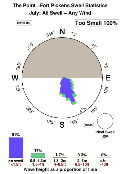
Overall The Point -Fort Pickens Surf Consistency and Wind Distribution in Juillet
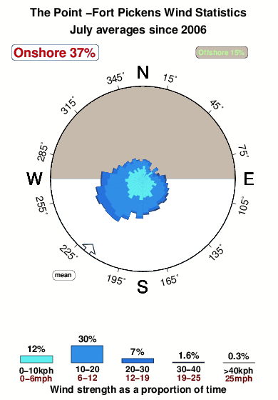


Wind stats for The Point -Fort Pickens: see the variation in direction and stength by month.
Photos de Surf
de la galerieContours: Routes et Rivières: Sélectionnez un spot de surf du menu 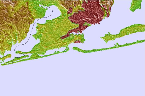
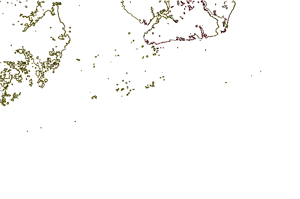
Utilisez cette carte en relief pour naviguer vers les spots de surf de Florida - Gulf, et les stations de marées aux alentours de The Point -Fort Pickens
Spots de Surf les plus proches de The Point -Fort Pickens:
(Cliquez sur le nom du spot pour plus de détails)- Closest spot10 mi
- Second closest spot10 mi
- Third closest spot11 mi
- Fourth closest spot13 mi
- Fifth closest spot15 mi
Bouées marines les plus proches de The Point -Fort Pickens:
- Closest Bouées marines24 mi
- Second closest Bouées marines89 mi
- Third closest Bouées marines132 mi
- Fourth closest Bouées marines165 mi
- Fifth closest Bouées marines191 mi
Stations de marée les plus proches de The Point -Fort Pickens:
- Closest station de maréePensacola Bay Entrance, Pensacola Bay1 mi
- Second closest station de maréeWarrington, 2 miles south of, Pensacola Bay2 mi
- Third closest station de maréeWarrington4 mi
- Fourth closest station de maréeMyrtle Grove6 mi
- Fifth closest station de maréeMillview, Perdido Bay7 mi
Airports
- The closest passenger airport to The Point -Fort Pickens is Pensacola Nas Airport (NPA) in USA, 3 km (2 miles) away (directly).
- The second nearest airport to The Point -Fort Pickens is Pensacola Rgnl Airport (PNS), also in USA, 20 km (12 miles) away.
- Third is Whiting Fld Nas North (Milton) Airport (NSE) in USA, 52 km (32 miles) away.
- Hurlburt Fld (Mary Esther) Airport (HRT) in USA is 60 km (37 miles) away.
- Eglin Afb (Valparaiso) Airport (VPS) in Usa (florida is the fifth nearest airport to The Point -Fort Pickens and is 77 km (48 miles) away.
- /breaks/The-Point_Fort-Pickens/forecasts/latest


 Nearest