

Texel (Waddeneilanden) Surf Guide
Texel (Waddeneilanden) on the West Coast is an exposed beach break that has inconsistent surf. Summer in particular tends to be flat. The best wind direction is from the east southeast. Tends to receive a mix of groundswells and windswells and the ideal swell direction is from the north northwest. The beach breaks offer lefts and rights. Rarely crowded here. Dangerous rips are a hazard of surfing here.
Texel (Waddeneilanden) Spot Info
| Type: | Rating: | Reliability: | Todays Sea Temp*: |
|---|---|---|---|
| inconsistent | 19.6°C*ocean temperature recorded from satellite |
Surfing Texel (Waddeneilanden):
The best conditions reported for surf at Texel (Waddeneilanden) occur when a North-northwest swell combines with an offshore wind direction from the East-southeast.
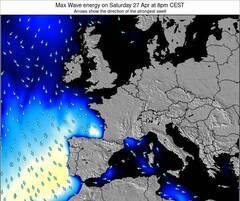
Énergie de Vague (puissance): 12h


Texel (Waddeneilanden) Surf:
Wednesday, 22 July 2026, 11:14 Local time| Mercredi 22 | ||||
| 11AM | 2PM | 5PM | 8PM | |
| Wave (m) | ||||
| Période (s) | 6 | 7 | 8 | 8 |
| Vent (km/h) | ||||
| Etat du vent | cross- on |
cross- on |
cross- on |
cross- on |
- /breaks/Texel_Waddeneilanden/forecasts/latest
Texel (Waddeneilanden) Surf Guide
Texel (Waddeneilanden) on the West Coast is an exposed beach break that has inconsistent surf. Summer in particular tends to be flat. The best wind direction is from the east southeast. Tends to receive a mix of groundswells and windswells and the ideal swell direction is from the north northwest. The beach breaks offer lefts and rights. Rarely crowded here. Dangerous rips are a hazard of surfing here.
Texel (Waddeneilanden) Spot Info
Type: Rating: Reliability: Todays Sea Temp*:  Sandbar
 3
3inconsistent 19.6°C*ocean temperature recorded from satelliteSurfing Texel (Waddeneilanden):
The best conditions reported for surf at Texel (Waddeneilanden) occur when a North-northwest swell combines with an offshore wind direction from the East-southeast.
Énergie de Vague (puissance): 12h
Utilisez les onglets ci-dessus pour voir la température de la mer à Texel (Waddeneilanden), photos pour Texel (Waddeneilanden), prévisions de houle détaillées pour Texel (Waddeneilanden), prévisions de vent et météo, webcams pour Texel (Waddeneilanden), conditions de vents en temps réel à partir des données de la station météo de Netherlands et prévisions des marées pour Texel (Waddeneilanden). Les cartes de houle pour Netherlands afficheront une image agrandie de Netherlands et des ses mers environnantes. Ces cartes de houles peuvent êtres animées pour montrer les différents composantes de houle, la hauteur, la période et l'énergie des vagues avec les prévisions météo et prévisions de vent. Des observations en temps réel du temps et de l'état de la mer sont fournies grâce aux bouées marines de Netherlands, des navires de passages, et des stations météo côtières. Toutes les pages de prévisions pour ce spot de surf ont un Vagu-o-Mètre Local et Global pour facilement trouver les meilleurs spot de surf à proximité de Texel (Waddeneilanden).
Texel (Waddeneilanden) Surf:
Wednesday, 22 July 2026, 11:14 Local timeMercredi 22 11AM 2PM 5PM 8PM Wave (m) Période (s) 6 7 8 8 Vent (km/h) Etat du vent cross-
oncross-
oncross-
oncross-
on- /breaks/Texel_Waddeneilanden/forecasts/latest
- /breaks/Texel_Waddeneilanden/forecasts/latest/six_day
Texel (Waddeneilanden) Surf Guide
Texel (Waddeneilanden) on the West Coast is an exposed beach break that has inconsistent surf. Summer in particular tends to be flat. The best wind direction is from the east southeast. Tends to receive a mix of groundswells and windswells and the ideal swell direction is from the north northwest. The beach breaks offer lefts and rights. Rarely crowded here. Dangerous rips are a hazard of surfing here.
Texel (Waddeneilanden) Spot Info
Type: Rating: Reliability: Todays Sea Temp*: Sandbar3inconsistent 19.6°C*ocean temperature recorded from satelliteSurfing Texel (Waddeneilanden):
The best conditions reported for surf at Texel (Waddeneilanden) occur when a North-northwest swell combines with an offshore wind direction from the East-southeast.
Énergie de Vague (puissance): 12h
Utilisez les onglets ci-dessus pour voir la température de la mer à Texel (Waddeneilanden), photos pour Texel (Waddeneilanden), prévisions de houle détaillées pour Texel (Waddeneilanden), prévisions de vent et météo, webcams pour Texel (Waddeneilanden), conditions de vents en temps réel à partir des données de la station météo de Netherlands et prévisions des marées pour Texel (Waddeneilanden). Les cartes de houle pour Netherlands afficheront une image agrandie de Netherlands et des ses mers environnantes. Ces cartes de houles peuvent êtres animées pour montrer les différents composantes de houle, la hauteur, la période et l'énergie des vagues avec les prévisions météo et prévisions de vent. Des observations en temps réel du temps et de l'état de la mer sont fournies grâce aux bouées marines de Netherlands, des navires de passages, et des stations météo côtières. Toutes les pages de prévisions pour ce spot de surf ont un Vagu-o-Mètre Local et Global pour facilement trouver les meilleurs spot de surf à proximité de Texel (Waddeneilanden).
Texel (Waddeneilanden) Surf:
Wednesday, 22 July 2026, 11:14 Local timeMercredi 22 11AM 2PM 5PM 8PM Wave (m) Période (s) 6 7 8 8 Vent (km/h) Etat du vent cross-
oncross-
oncross-
oncross-
on- /breaks/Texel_Waddeneilanden/forecasts/latest
Texel (Waddeneilanden) Surf Guide
Texel (Waddeneilanden) on the West Coast is an exposed beach break that has inconsistent surf. Summer in particular tends to be flat. The best wind direction is from the east southeast. Tends to receive a mix of groundswells and windswells and the ideal swell direction is from the north northwest. The beach breaks offer lefts and rights. Rarely crowded here. Dangerous rips are a hazard of surfing here.
Texel (Waddeneilanden) Spot Info
Type: Rating: Reliability: Todays Sea Temp*: Sandbar3inconsistent 19.6°C*ocean temperature recorded from satelliteSurfing Texel (Waddeneilanden):
The best conditions reported for surf at Texel (Waddeneilanden) occur when a North-northwest swell combines with an offshore wind direction from the East-southeast.
Énergie de Vague (puissance): 12h
Utilisez les onglets ci-dessus pour voir la température de la mer à Texel (Waddeneilanden), photos pour Texel (Waddeneilanden), prévisions de houle détaillées pour Texel (Waddeneilanden), prévisions de vent et météo, webcams pour Texel (Waddeneilanden), conditions de vents en temps réel à partir des données de la station météo de Netherlands et prévisions des marées pour Texel (Waddeneilanden). Les cartes de houle pour Netherlands afficheront une image agrandie de Netherlands et des ses mers environnantes. Ces cartes de houles peuvent êtres animées pour montrer les différents composantes de houle, la hauteur, la période et l'énergie des vagues avec les prévisions météo et prévisions de vent. Des observations en temps réel du temps et de l'état de la mer sont fournies grâce aux bouées marines de Netherlands, des navires de passages, et des stations météo côtières. Toutes les pages de prévisions pour ce spot de surf ont un Vagu-o-Mètre Local et Global pour facilement trouver les meilleurs spot de surf à proximité de Texel (Waddeneilanden).
Texel (Waddeneilanden) Surf:
Wednesday, 22 July 2026, 11:14 Local timeMercredi 22 11AM 2PM 5PM 8PM Wave (m) Période (s) 6 7 8 8 Vent (km/h) Etat du vent cross-
oncross-
oncross-
oncross-
onTide Times:
Pour Den Helder, Netherlands, %{dist} %{km} de %{location}.
PROCHAIN EST A (heure locale) il reste marée haute marée basse Texel (Waddeneilanden) Tide Times and Tide Chart
Live Weather:
At Texel Hors, 2 km from Texel (Waddeneilanden).
light winds from the W
(km/h)
no reportAir temperature
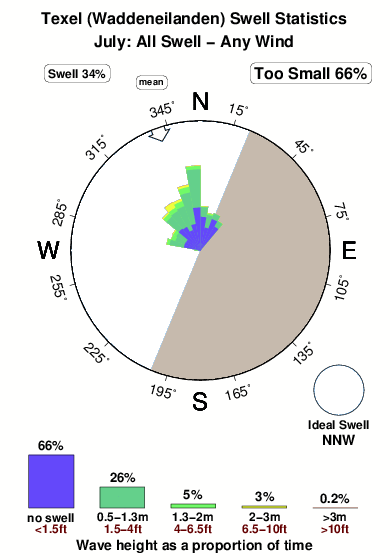
-°COverall Texel (Waddeneilanden) Surf Consistency and Wind Distribution in Juillet
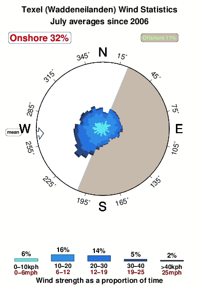


Wind stats for Texel (Waddeneilanden): see the variation in direction and stength by month.
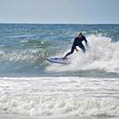
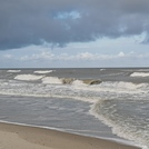
Photos de Surf
de la galerieContours: Routes et Rivières: Sélectionnez un spot de surf du menu 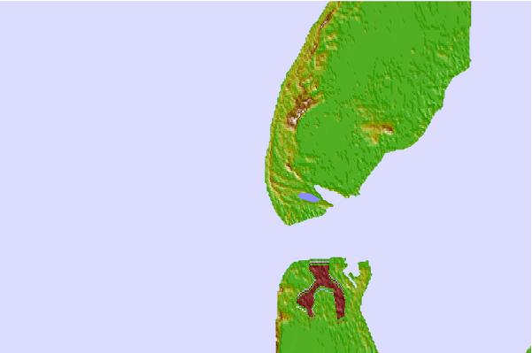

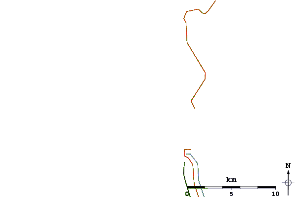
Utilisez cette carte en relief pour naviguer vers les spots de surf de Netherlands, et les stations de marées aux alentours de Texel (Waddeneilanden)
Spots de Surf les plus proches de Texel (Waddeneilanden):
(Cliquez sur le nom du spot pour plus de détails)- Closest spot6 mi
- Second closest spot14 mi
- Third closest spot15 mi
- Fourth closest spot16 mi
- Fifth closest spot25 mi
Bouées marines les plus proches de Texel (Waddeneilanden):
- Closest Bouées marines71 mi
- Second closest Bouées marines78 mi
- Third closest Bouées marines80 mi
- Fourth closest Bouées marines91 mi
- Fifth closest Bouées marines108 mi
Stations de marée les plus proches de Texel (Waddeneilanden):
- Closest station de maréeDen Helder4 mi
- Second closest station de maréeDen Burg5 mi
- Third closest station de maréeOude Schild6 mi
- Fourth closest station de maréeTexel Noordzee7 mi
- Fifth closest station de maréePetten zuid17 mi
Airports
- The closest passenger airport to Texel (Waddeneilanden) is De Kooy Airport (DHR) in Netherlands, 11 km (7 miles) away (directly).
- The second nearest airport to Texel (Waddeneilanden) is Leeuwarden Airport (LWR), also in Netherlands, 74 km (46 miles) away.
- Third is Schiphol (Amsterdam) Airport (AMS) in Netherlands, 79 km (49 miles) away.
- Valkenburg Airport (LID) in Netherlands is 96 km (60 miles) away.
- Soesterberg Airport (UTC), also in Netherlands is the fifth nearest airport to Texel (Waddeneilanden) and is 106 km (66 miles) away.

- /breaks/Texel_Waddeneilanden/forecasts/latest


 Nearest