

South Padre Island Surf Guide
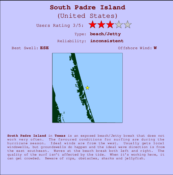
South Padre Island in Texas is an exposed beach/Jetty break that does not work very often. The best conditions for surfing are during the hurricane season. Offshore winds blow from the west. Most of the surf comes fis in the form of windswells and the ideal wave direction is from the east southeast. The beach break provides left and right handers. Good surf at all stages of the tide. Sometimes crowded. Hazards include rips, obstacles, sharks and jellyfish.
South Padre Island Spot Info
| Type: | Rating: | Reliability: | Todays Sea Temp*: |
|---|---|---|---|
| inconsistent | 28.3°C*ocean temperature recorded from satellite |
Surfing South Padre Island:
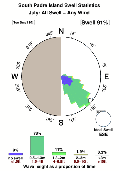
The best conditions reported for surf at South Padre Island occur when a East-southeast swell combines with an offshore wind direction from the West.
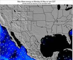
Énergie de Vague (puissance): 12h
South Padre Island Surf:
Sunday, 19 July 2026, 05:02 Local time| Dimanche 19 | ||||
| 4AM | 7AM | 10AM | 1PM | |
| Wave (m) | ||||
| Période (s) | 5 | 5 | 5 | 4 |
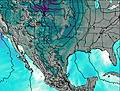
| Vent (km/h) | ||||
| Etat du vent | cross | cross | cross- on |
cross- on |
- /breaks/South-Padre-Island/forecasts/latest
South Padre Island Surf Guide
South Padre Island in Texas is an exposed beach/Jetty break that does not work very often. The best conditions for surfing are during the hurricane season. Offshore winds blow from the west. Most of the surf comes fis in the form of windswells and the ideal wave direction is from the east southeast. The beach break provides left and right handers. Good surf at all stages of the tide. Sometimes crowded. Hazards include rips, obstacles, sharks and jellyfish.
South Padre Island Spot Info
Type: Rating: Reliability: Todays Sea Temp*:  Beach/jetty
 3
3inconsistent 28.3°C*ocean temperature recorded from satelliteSurfing South Padre Island:
The best conditions reported for surf at South Padre Island occur when a East-southeast swell combines with an offshore wind direction from the West.
Énergie de Vague (puissance): 12h
Utilisez les onglets ci-dessus pour voir la température de la mer à South Padre Island, photos pour South Padre Island, prévisions de houle détaillées pour South Padre Island, prévisions de vent et météo, webcams pour South Padre Island, conditions de vents en temps réel à partir des données de la station météo de Texas et prévisions des marées pour South Padre Island. Les cartes de houle pour United States afficheront une image agrandie de United States et des ses mers environnantes. Ces cartes de houles peuvent êtres animées pour montrer les différents composantes de houle, la hauteur, la période et l'énergie des vagues avec les prévisions météo et prévisions de vent. Des observations en temps réel du temps et de l'état de la mer sont fournies grâce aux bouées marines de United States, des navires de passages, et des stations météo côtières. Toutes les pages de prévisions pour ce spot de surf ont un Vagu-o-Mètre Local et Global pour facilement trouver les meilleurs spot de surf à proximité de South Padre Island.
South Padre Island Surf:
Sunday, 19 July 2026, 05:02 Local timeDimanche 19 4AM 7AM 10AM 1PM Wave (m) Période (s) 5 5 5 4 Vent (km/h) Etat du vent cross cross cross-
oncross-
on- /breaks/South-Padre-Island/forecasts/latest
- /breaks/South-Padre-Island/forecasts/latest/six_day
South Padre Island Surf Guide
South Padre Island in Texas is an exposed beach/Jetty break that does not work very often. The best conditions for surfing are during the hurricane season. Offshore winds blow from the west. Most of the surf comes fis in the form of windswells and the ideal wave direction is from the east southeast. The beach break provides left and right handers. Good surf at all stages of the tide. Sometimes crowded. Hazards include rips, obstacles, sharks and jellyfish.
South Padre Island Spot Info
Type: Rating: Reliability: Todays Sea Temp*: Beach/jetty3inconsistent 28.3°C*ocean temperature recorded from satelliteSurfing South Padre Island:
The best conditions reported for surf at South Padre Island occur when a East-southeast swell combines with an offshore wind direction from the West.
Énergie de Vague (puissance): 12h
Utilisez les onglets ci-dessus pour voir la température de la mer à South Padre Island, photos pour South Padre Island, prévisions de houle détaillées pour South Padre Island, prévisions de vent et météo, webcams pour South Padre Island, conditions de vents en temps réel à partir des données de la station météo de Texas et prévisions des marées pour South Padre Island. Les cartes de houle pour United States afficheront une image agrandie de United States et des ses mers environnantes. Ces cartes de houles peuvent êtres animées pour montrer les différents composantes de houle, la hauteur, la période et l'énergie des vagues avec les prévisions météo et prévisions de vent. Des observations en temps réel du temps et de l'état de la mer sont fournies grâce aux bouées marines de United States, des navires de passages, et des stations météo côtières. Toutes les pages de prévisions pour ce spot de surf ont un Vagu-o-Mètre Local et Global pour facilement trouver les meilleurs spot de surf à proximité de South Padre Island.
South Padre Island Surf:
Sunday, 19 July 2026, 05:02 Local timeDimanche 19 4AM 7AM 10AM 1PM Wave (m) Période (s) 5 5 5 4 Vent (km/h) Etat du vent cross cross cross-
oncross-
on- /breaks/South-Padre-Island/forecasts/latest
South Padre Island Surf Guide
South Padre Island in Texas is an exposed beach/Jetty break that does not work very often. The best conditions for surfing are during the hurricane season. Offshore winds blow from the west. Most of the surf comes fis in the form of windswells and the ideal wave direction is from the east southeast. The beach break provides left and right handers. Good surf at all stages of the tide. Sometimes crowded. Hazards include rips, obstacles, sharks and jellyfish.
South Padre Island Spot Info
Type: Rating: Reliability: Todays Sea Temp*: Beach/jetty3inconsistent 28.3°C*ocean temperature recorded from satelliteSurfing South Padre Island:
The best conditions reported for surf at South Padre Island occur when a East-southeast swell combines with an offshore wind direction from the West.
Énergie de Vague (puissance): 12h
Utilisez les onglets ci-dessus pour voir la température de la mer à South Padre Island, photos pour South Padre Island, prévisions de houle détaillées pour South Padre Island, prévisions de vent et météo, webcams pour South Padre Island, conditions de vents en temps réel à partir des données de la station météo de Texas et prévisions des marées pour South Padre Island. Les cartes de houle pour United States afficheront une image agrandie de United States et des ses mers environnantes. Ces cartes de houles peuvent êtres animées pour montrer les différents composantes de houle, la hauteur, la période et l'énergie des vagues avec les prévisions météo et prévisions de vent. Des observations en temps réel du temps et de l'état de la mer sont fournies grâce aux bouées marines de United States, des navires de passages, et des stations météo côtières. Toutes les pages de prévisions pour ce spot de surf ont un Vagu-o-Mètre Local et Global pour facilement trouver les meilleurs spot de surf à proximité de South Padre Island.
South Padre Island Surf:
Sunday, 19 July 2026, 05:02 Local timeDimanche 19 4AM 7AM 10AM 1PM Wave (m) Période (s) 5 5 5 4 Vent (km/h) Etat du vent cross cross cross-
oncross-
onTide Times:
Pour Port Mansfield Jetty, %{dist} %{km} de %{location}.
PROCHAIN EST A (heure locale) il reste marée haute marée basse South Padre Island Tide Times and Tide Chart
Live Weather:
At BUOY-PMNT2, 17 km from South Padre Island.
- Air temperature
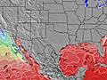
-°COverall South Padre Island Surf Consistency and Wind Distribution in Juillet
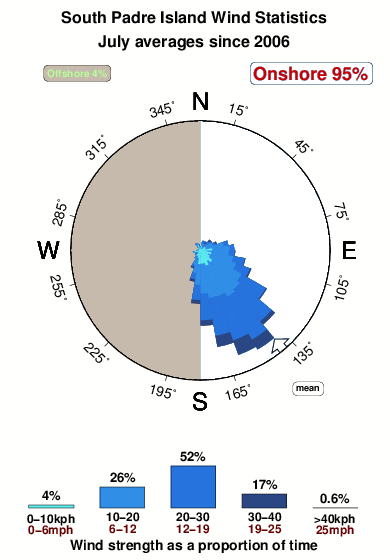


Wind stats for South Padre Island: see the variation in direction and stength by month.
Photos de Surf
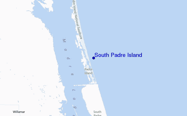
de la galerieContours: Routes et Rivières: Sélectionnez un spot de surf du menu 


Utilisez cette carte en relief pour naviguer vers les spots de surf de Texas, et les stations de marées aux alentours de South Padre Island
Spots de Surf les plus proches de South Padre Island:
(Cliquez sur le nom du spot pour plus de détails)- Closest spot6 mi
- Second closest spot38 mi
- Third closest spot40 mi
- Fourth closest spot40 mi
- Fifth closest spot42 mi
Bouées marines les plus proches de South Padre Island:
- Closest Bouées marines42 mi
- Second closest Bouées marines147 mi
- Third closest Bouées marines232 mi
- Fourth closest Bouées marines250 mi
- Fifth closest Bouées marines380 mi
Stations de marée les plus proches de South Padre Island:
- Closest station de maréeQueen Isabella Causeway (east end)41 mi
- Second closest station de maréeCoast Guard Station, South Padre Island42 mi
- Third closest station de maréeQueen Isabella Causeway (west end)42 mi
- Fourth closest station de maréePadre Island (South)42 mi
- Fifth closest station de maréePort Isabel42 mi
Airports
- The closest passenger airport to South Padre Island is Valley International (Harlingen) Airport (HRL) in USA, 61 km (38 miles) away (directly).
- The second nearest airport to South Padre Island is Brownsville South Padre Island International Airport (BRO), also in USA, 86 km (53 miles) away.
- Third is General Servando Canales International (Matamoros) Airport (MAM) in Mexico, 102 km (63 miles) away.
- Kingsville Nas Airport (NQI) in USA is 107 km (66 miles) away.
- Mc Allen Miller International (Mcallen) Airport (MFE), also in USA is the fifth nearest airport to South Padre Island and is 109 km (68 miles) away.
- /breaks/South-Padre-Island/forecasts/latest

 Nearest