

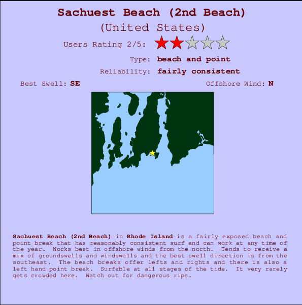
Sachuest Beach (2nd Beach) Surf Guide
Sachuest Beach(2nd Beach) in Rhode Island is a fairly exposed beach and point break that has fairly consistent surf and can work at any time of the year. The best wind direction is from the north. Windswells and groundswells in equal measure and the best swell direction is from the southeast. Waves at the beach break both left and right and there is a left hand point break as well. The quality of the surf isn't affected by the tide. Even when there are waves, it's not likley to be crowded. Dangerous rips are a hazard of surfing here.
Sachuest Beach (2nd Beach) Spot Info
| Type: | Rating: | Reliability: | Todays Sea Temp*: |
|---|---|---|---|
| fairly consistent | 21.5°C*ocean temperature recorded from satellite |
Surfing Sachuest Beach (2nd Beach):
The best conditions reported for surf at Sachuest Beach (2nd Beach) occur when a Southeast swell combines with an offshore wind direction from the North.

Énergie de Vague (puissance): 12h


Sachuest Beach (2nd Beach) Surf:
Monday, 3 August 2026, 10:21 Local time| Lundi 03 | ||||
| 11AM | 2PM | 5PM | 8PM | |
| Wave (m) | ||||
| Période (s) | 8 | 9 | 9 | 9 |
| Vent (km/h) | ||||
| Etat du vent | on | cross- on |
cross- on |
cross- on |
- /breaks/Sachuest-Beach/forecasts/latest
Sachuest Beach (2nd Beach) Surf Guide
Sachuest Beach(2nd Beach) in Rhode Island is a fairly exposed beach and point break that has fairly consistent surf and can work at any time of the year. The best wind direction is from the north. Windswells and groundswells in equal measure and the best swell direction is from the southeast. Waves at the beach break both left and right and there is a left hand point break as well. The quality of the surf isn't affected by the tide. Even when there are waves, it's not likley to be crowded. Dangerous rips are a hazard of surfing here.
Sachuest Beach (2nd Beach) Spot Info
Type: Rating: Reliability: Todays Sea Temp*:  Beach and point
 2
2fairly consistent 21.5°C*ocean temperature recorded from satelliteSurfing Sachuest Beach (2nd Beach):
The best conditions reported for surf at Sachuest Beach (2nd Beach) occur when a Southeast swell combines with an offshore wind direction from the North.
Énergie de Vague (puissance): 12h
Utilisez les onglets ci-dessus pour voir la température de la mer à Sachuest Beach (2nd Beach), photos pour Sachuest Beach (2nd Beach), prévisions de houle détaillées pour Sachuest Beach (2nd Beach), prévisions de vent et météo, webcams pour Sachuest Beach (2nd Beach), conditions de vents en temps réel à partir des données de la station météo de Rhode Island et prévisions des marées pour Sachuest Beach (2nd Beach). Les cartes de houle pour United States afficheront une image agrandie de United States et des ses mers environnantes. Ces cartes de houles peuvent êtres animées pour montrer les différents composantes de houle, la hauteur, la période et l'énergie des vagues avec les prévisions météo et prévisions de vent. Des observations en temps réel du temps et de l'état de la mer sont fournies grâce aux bouées marines de United States, des navires de passages, et des stations météo côtières. Toutes les pages de prévisions pour ce spot de surf ont un Vagu-o-Mètre Local et Global pour facilement trouver les meilleurs spot de surf à proximité de Sachuest Beach (2nd Beach).
Sachuest Beach (2nd Beach) Surf:
Monday, 3 August 2026, 10:21 Local timeLundi 03 11AM 2PM 5PM 8PM Wave (m) Période (s) 8 9 9 9 Vent (km/h) Etat du vent on cross-
oncross-
oncross-
on- /breaks/Sachuest-Beach/forecasts/latest
- /breaks/Sachuest-Beach/forecasts/latest/six_day
Sachuest Beach (2nd Beach) Surf Guide
Sachuest Beach(2nd Beach) in Rhode Island is a fairly exposed beach and point break that has fairly consistent surf and can work at any time of the year. The best wind direction is from the north. Windswells and groundswells in equal measure and the best swell direction is from the southeast. Waves at the beach break both left and right and there is a left hand point break as well. The quality of the surf isn't affected by the tide. Even when there are waves, it's not likley to be crowded. Dangerous rips are a hazard of surfing here.
Sachuest Beach (2nd Beach) Spot Info
Type: Rating: Reliability: Todays Sea Temp*: Beach and point2fairly consistent 21.5°C*ocean temperature recorded from satelliteSurfing Sachuest Beach (2nd Beach):
The best conditions reported for surf at Sachuest Beach (2nd Beach) occur when a Southeast swell combines with an offshore wind direction from the North.
Énergie de Vague (puissance): 12h
Utilisez les onglets ci-dessus pour voir la température de la mer à Sachuest Beach (2nd Beach), photos pour Sachuest Beach (2nd Beach), prévisions de houle détaillées pour Sachuest Beach (2nd Beach), prévisions de vent et météo, webcams pour Sachuest Beach (2nd Beach), conditions de vents en temps réel à partir des données de la station météo de Rhode Island et prévisions des marées pour Sachuest Beach (2nd Beach). Les cartes de houle pour United States afficheront une image agrandie de United States et des ses mers environnantes. Ces cartes de houles peuvent êtres animées pour montrer les différents composantes de houle, la hauteur, la période et l'énergie des vagues avec les prévisions météo et prévisions de vent. Des observations en temps réel du temps et de l'état de la mer sont fournies grâce aux bouées marines de United States, des navires de passages, et des stations météo côtières. Toutes les pages de prévisions pour ce spot de surf ont un Vagu-o-Mètre Local et Global pour facilement trouver les meilleurs spot de surf à proximité de Sachuest Beach (2nd Beach).
Sachuest Beach (2nd Beach) Surf:
Monday, 3 August 2026, 10:21 Local timeLundi 03 11AM 2PM 5PM 8PM Wave (m) Période (s) 8 9 9 9 Vent (km/h) Etat du vent on cross-
oncross-
oncross-
on- /breaks/Sachuest-Beach/forecasts/latest
Sachuest Beach (2nd Beach) Surf Guide
Sachuest Beach(2nd Beach) in Rhode Island is a fairly exposed beach and point break that has fairly consistent surf and can work at any time of the year. The best wind direction is from the north. Windswells and groundswells in equal measure and the best swell direction is from the southeast. Waves at the beach break both left and right and there is a left hand point break as well. The quality of the surf isn't affected by the tide. Even when there are waves, it's not likley to be crowded. Dangerous rips are a hazard of surfing here.
Sachuest Beach (2nd Beach) Spot Info
Type: Rating: Reliability: Todays Sea Temp*: Beach and point2fairly consistent 21.5°C*ocean temperature recorded from satelliteSurfing Sachuest Beach (2nd Beach):
The best conditions reported for surf at Sachuest Beach (2nd Beach) occur when a Southeast swell combines with an offshore wind direction from the North.
Énergie de Vague (puissance): 12h
Utilisez les onglets ci-dessus pour voir la température de la mer à Sachuest Beach (2nd Beach), photos pour Sachuest Beach (2nd Beach), prévisions de houle détaillées pour Sachuest Beach (2nd Beach), prévisions de vent et météo, webcams pour Sachuest Beach (2nd Beach), conditions de vents en temps réel à partir des données de la station météo de Rhode Island et prévisions des marées pour Sachuest Beach (2nd Beach). Les cartes de houle pour United States afficheront une image agrandie de United States et des ses mers environnantes. Ces cartes de houles peuvent êtres animées pour montrer les différents composantes de houle, la hauteur, la période et l'énergie des vagues avec les prévisions météo et prévisions de vent. Des observations en temps réel du temps et de l'état de la mer sont fournies grâce aux bouées marines de United States, des navires de passages, et des stations météo côtières. Toutes les pages de prévisions pour ce spot de surf ont un Vagu-o-Mètre Local et Global pour facilement trouver les meilleurs spot de surf à proximité de Sachuest Beach (2nd Beach).
Sachuest Beach (2nd Beach) Surf:
Monday, 3 August 2026, 10:21 Local timeLundi 03 11AM 2PM 5PM 8PM Wave (m) Période (s) 8 9 9 9 Vent (km/h) Etat du vent on cross-
oncross-
oncross-
onTide Times:
Pour Sachuest, Flint Point, Sakonnet River, Rhode Island, %{dist} %{km} de %{location}.
PROCHAIN EST A (heure locale) il reste marée haute marée basse Sachuest Beach (2nd Beach) Tide Times and Tide Chart
Live Weather:
At SHIP117, 4 km from Sachuest Beach (2nd Beach).
strong winds from the S
(km/h)Air temperature
21.1°CCurrent weather near Sachuest Beach (2nd Beach)
Buoy Data:
At Block Island, RI, 36 miles from Sachuest Beach (2nd Beach).
5AM 6AM 7AM 8AM Age des données 4 hr 3 hr 2 hr 1 hr hauteur de la vague (m) 


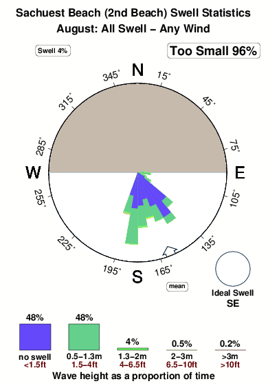
Période Dominante (s) 6 7 8 8 Overall Sachuest Beach (2nd Beach) Surf Consistency and Wind Distribution in Août
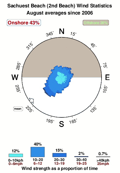


Wind stats for Sachuest Beach (2nd Beach): see the variation in direction and stength by month.
Photos de Surf
de la galerieContours: Routes et Rivières: Sélectionnez un spot de surf du menu 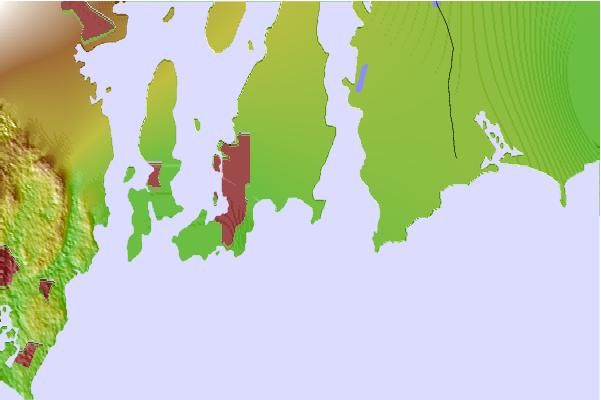
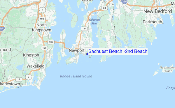
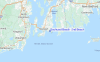
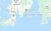
Utilisez cette carte en relief pour naviguer vers les spots de surf de Rhode Island, et les stations de marées aux alentours de Sachuest Beach (2nd Beach)
Spots de Surf les plus proches de Sachuest Beach (2nd Beach):
(Cliquez sur le nom du spot pour plus de détails)- Closest spot0 mi
- Second closest spot1 mi
- Third closest spot1 mi
- Fourth closest spot2 mi
- Fifth closest spot2 mi
Bouées marines les plus proches de Sachuest Beach (2nd Beach):
- Closest Bouées marines36 mi
- Second closest Bouées marines54 mi
- Third closest Bouées marines55 mi
- Fourth closest Bouées marines68 mi
- Fifth closest Bouées marines69 mi
Stations de marée les plus proches de Sachuest Beach (2nd Beach):
- Closest station de maréeSachuest, Flint Point, Sakonnet River1 mi
- Second closest station de maréeNewport4 mi
- Third closest station de maréeSakonnet, Narragansett Bay4 mi
- Fourth closest station de maréeMiddletown4 mi
- Fifth closest station de maréeThe Glen, Sakonnet River5 mi
Airports
- The closest passenger airport to Sachuest Beach (2nd Beach) is Theodore Francis Green State (Providence) Airport (PVD) in USA, 30 km (19 miles) away (directly).
- The second nearest airport to Sachuest Beach (2nd Beach) is North Central State (Smithfield) Airport (SFZ), also in USA, 52 km (32 miles) away.
- Third is Otis Angb (Falmouth) Airport (FMH) in USA, 64 km (40 miles) away.
- General Edward Lawrence Logan International (Boston) Airport (BOS) in USA is 100 km (62 miles) away.
- Nantucket Mem Airport (ACK), also in USA is the fifth nearest airport to Sachuest Beach (2nd Beach) and is 103 km (64 miles) away.
- /breaks/Sachuest-Beach/forecasts/latest


 Nearest