

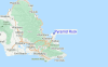
Pyramid Rock Surf Guide
Pyramid Rock in Oahu is an exposed point break that has fairly consistent surf and can work at any time of the year. The best wind direction is from the south southwest. Groundswells are more common than windswells and the ideal swell direction is from the northeast. Waves at the beach break both left and right. When it's working here, it can get crowded. Beware of rocks/rips.
Pyramid Rock Spot Info
| Type: | Rating: | Reliability: | Todays Sea Temp*: |
|---|---|---|---|
| fairly consistent | 26.2°C*ocean temperature recorded from satellite |
Surfing Pyramid Rock:
The best conditions reported for surf at Pyramid Rock occur when a North-northeast swell combines with an offshore wind direction from the South-southwest.
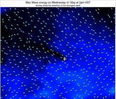
Énergie de Vague (puissance): 12h

Pyramid Rock Surf:
Friday, 17 July 2026, 04:00 Local time| Vendredi 17 | ||||
| 5AM | 8AM | 11AM | 2PM | |
| Wave (m) | ||||
| Période (s) | 6 | 6 | 6 | 7 |
| Vent (km/h) | ||||
| Etat du vent | cross- on |
cross- on |
cross- on |
cross- on |
- /breaks/Pyramid-Rock/forecasts/latest
Pyramid Rock Surf Guide
Pyramid Rock in Oahu is an exposed point break that has fairly consistent surf and can work at any time of the year. The best wind direction is from the south southwest. Groundswells are more common than windswells and the ideal swell direction is from the northeast. Waves at the beach break both left and right. When it's working here, it can get crowded. Beware of rocks/rips.
Pyramid Rock Spot Info
Type: Rating: Reliability: Todays Sea Temp*:  Reef
Reef 2
2fairly consistent 26.2°C*ocean temperature recorded from satelliteSurfing Pyramid Rock:
The best conditions reported for surf at Pyramid Rock occur when a North-northeast swell combines with an offshore wind direction from the South-southwest.
Énergie de Vague (puissance): 12h
Utilisez les onglets ci-dessus pour voir la température de la mer à Pyramid Rock, photos pour Pyramid Rock, prévisions de houle détaillées pour Pyramid Rock, prévisions de vent et météo, webcams pour Pyramid Rock, conditions de vents en temps réel à partir des données de la station météo de HAW - Oahu et prévisions des marées pour Pyramid Rock. Les cartes de houle pour United States afficheront une image agrandie de United States et des ses mers environnantes. Ces cartes de houles peuvent êtres animées pour montrer les différents composantes de houle, la hauteur, la période et l'énergie des vagues avec les prévisions météo et prévisions de vent. Des observations en temps réel du temps et de l'état de la mer sont fournies grâce aux bouées marines de United States, des navires de passages, et des stations météo côtières. Toutes les pages de prévisions pour ce spot de surf ont un Vagu-o-Mètre Local et Global pour facilement trouver les meilleurs spot de surf à proximité de Pyramid Rock.
Pyramid Rock Surf:
Friday, 17 July 2026, 04:00 Local timeVendredi 17 5AM 8AM 11AM 2PM Wave (m) Période (s) 6 6 6 7 Vent (km/h) Etat du vent cross-
oncross-
oncross-
oncross-
on- /breaks/Pyramid-Rock/forecasts/latest
- /breaks/Pyramid-Rock/forecasts/latest/six_day
Pyramid Rock Surf Guide
Pyramid Rock in Oahu is an exposed point break that has fairly consistent surf and can work at any time of the year. The best wind direction is from the south southwest. Groundswells are more common than windswells and the ideal swell direction is from the northeast. Waves at the beach break both left and right. When it's working here, it can get crowded. Beware of rocks/rips.
Pyramid Rock Spot Info
Type: Rating: Reliability: Todays Sea Temp*: Reef2fairly consistent 26.2°C*ocean temperature recorded from satelliteSurfing Pyramid Rock:
The best conditions reported for surf at Pyramid Rock occur when a North-northeast swell combines with an offshore wind direction from the South-southwest.
Énergie de Vague (puissance): 12h
Utilisez les onglets ci-dessus pour voir la température de la mer à Pyramid Rock, photos pour Pyramid Rock, prévisions de houle détaillées pour Pyramid Rock, prévisions de vent et météo, webcams pour Pyramid Rock, conditions de vents en temps réel à partir des données de la station météo de HAW - Oahu et prévisions des marées pour Pyramid Rock. Les cartes de houle pour United States afficheront une image agrandie de United States et des ses mers environnantes. Ces cartes de houles peuvent êtres animées pour montrer les différents composantes de houle, la hauteur, la période et l'énergie des vagues avec les prévisions météo et prévisions de vent. Des observations en temps réel du temps et de l'état de la mer sont fournies grâce aux bouées marines de United States, des navires de passages, et des stations météo côtières. Toutes les pages de prévisions pour ce spot de surf ont un Vagu-o-Mètre Local et Global pour facilement trouver les meilleurs spot de surf à proximité de Pyramid Rock.
Pyramid Rock Surf:
Friday, 17 July 2026, 04:00 Local timeVendredi 17 5AM 8AM 11AM 2PM Wave (m) Période (s) 6 6 6 7 Vent (km/h) Etat du vent cross-
oncross-
oncross-
oncross-
on- /breaks/Pyramid-Rock/forecasts/latest
Pyramid Rock Surf Guide
Pyramid Rock in Oahu is an exposed point break that has fairly consistent surf and can work at any time of the year. The best wind direction is from the south southwest. Groundswells are more common than windswells and the ideal swell direction is from the northeast. Waves at the beach break both left and right. When it's working here, it can get crowded. Beware of rocks/rips.
Pyramid Rock Spot Info
Type: Rating: Reliability: Todays Sea Temp*: Reef2fairly consistent 26.2°C*ocean temperature recorded from satelliteSurfing Pyramid Rock:
The best conditions reported for surf at Pyramid Rock occur when a North-northeast swell combines with an offshore wind direction from the South-southwest.
Énergie de Vague (puissance): 12h
Utilisez les onglets ci-dessus pour voir la température de la mer à Pyramid Rock, photos pour Pyramid Rock, prévisions de houle détaillées pour Pyramid Rock, prévisions de vent et météo, webcams pour Pyramid Rock, conditions de vents en temps réel à partir des données de la station météo de HAW - Oahu et prévisions des marées pour Pyramid Rock. Les cartes de houle pour United States afficheront une image agrandie de United States et des ses mers environnantes. Ces cartes de houles peuvent êtres animées pour montrer les différents composantes de houle, la hauteur, la période et l'énergie des vagues avec les prévisions météo et prévisions de vent. Des observations en temps réel du temps et de l'état de la mer sont fournies grâce aux bouées marines de United States, des navires de passages, et des stations météo côtières. Toutes les pages de prévisions pour ce spot de surf ont un Vagu-o-Mètre Local et Global pour facilement trouver les meilleurs spot de surf à proximité de Pyramid Rock.
Pyramid Rock Surf:
Friday, 17 July 2026, 04:00 Local timeVendredi 17 5AM 8AM 11AM 2PM Wave (m) Période (s) 6 6 6 7 Vent (km/h) Etat du vent cross-
oncross-
oncross-
oncross-
onTide Times:
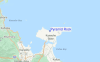
Pour Mokuoloe, Kaneohe Bay, Oahu Island, Hawaii, %{dist} %{km} de %{location}.
PROCHAIN EST A (heure locale) il reste marée haute marée basse Pyramid Rock Tide Times and Tide Chart
Live Weather:
At Kaneohe Bay Marine Corps Airfield Airport, 3 km from Pyramid Rock.
light winds from the E
(km/h)
Dry and partly cloudyAir temperature
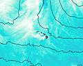
25.6°COverall Pyramid Rock Surf Consistency and Wind Distribution in Juillet


Wind stats for Pyramid Rock: see the variation in direction and stength by month.
Photos de Surf
de la galerieContours: Routes et Rivières: Sélectionnez un spot de surf du menu 


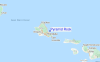
Utilisez cette carte en relief pour naviguer vers les spots de surf de HAW - Oahu, et les stations de marées aux alentours de Pyramid Rock
Spots de Surf les plus proches de Pyramid Rock:
(Cliquez sur le nom du spot pour plus de détails)- Closest spot2 mi
- Second closest spot2 mi
- Third closest spot3 mi
- Fourth closest spot3 mi
- Fifth closest spot4 mi
Bouées marines les plus proches de Pyramid Rock:
- Closest Bouées marines2 mi
- Second closest Bouées marines2 mi
- Third closest Bouées marines5 mi
- Fourth closest Bouées marines17 mi
- Fifth closest Bouées marines27 mi
Stations de marée les plus proches de Pyramid Rock:
- Closest station de maréeMokuoloe, Kaneohe Bay, Oahu Island3 mi
- Second closest station de maréeKailua4 mi
- Third closest station de marée'Ahuimanu6 mi
- Fourth closest station de maréeWaikane, Kaneohe Bay, Oahu Island7 mi
- Fifth closest station de maréeWaimanalo, Oahu Island9 mi
Airports
- The closest passenger airport to Pyramid Rock is Kaneohe Bay Mcaf Airport (NGF) in Usa Oahu Isl., 2 km (1 miles) away (directly).
- The second nearest airport to Pyramid Rock is Honolulu International Airport (HNL), also in Usa Oahu Isl., 24 km (15 miles) away.
- Third is Dillingham Airport (HDH) in Usa Oahu Isl., 50 km (31 miles) away.
- Molokai Airport (MKK) in Usa Molokai Isl. is 76 km (47 miles) away.
- Lanai Airport (LNY) in Usa Lanai Isl. is the fifth nearest airport to Pyramid Rock and is 111 km (69 miles) away.

- /breaks/Pyramid-Rock/forecasts/latest


 Nearest