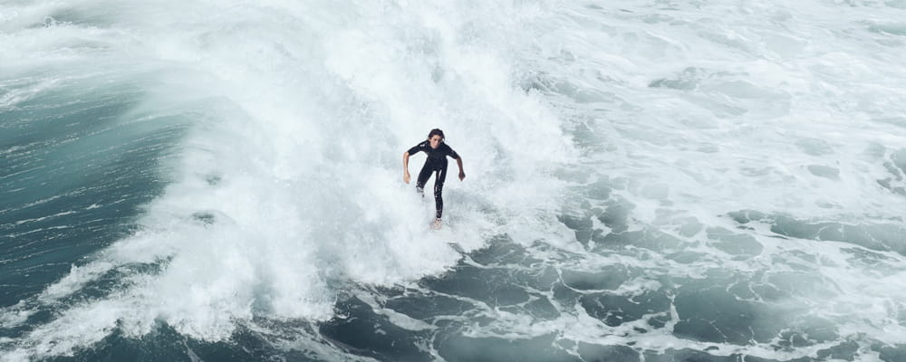
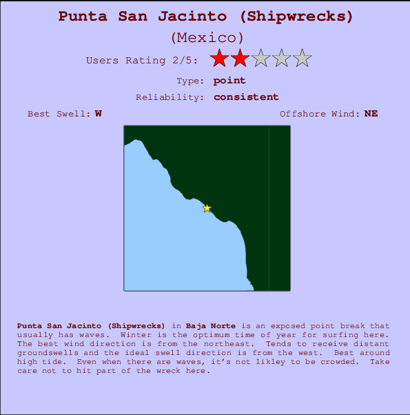
Punta San Jacinto (Shipwrecks) Surf Guide
Punta San Jacinto (Shipwrecks) in Baja Norte is an exposed point break that has dependable surf. Winter is the best time of year for surfing here. Offshore winds blow from the northeast. Groundswells more frequent than windswells and the optimum swell angle is from the west. Best around high tide. It very rarely gets crowded here. Take care not to hit part of the wreck here.
Punta San Jacinto (Shipwrecks) Spot Info
| Type: | Rating: | Reliability: | Todays Sea Temp*: |
|---|---|---|---|
| consistent | 20.0°C*ocean temperature recorded from satellite |
Surfing Punta San Jacinto (Shipwrecks):
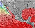
The best conditions reported for surf at Punta San Jacinto (Shipwrecks) occur when a West swell combines with an offshore wind direction from the Northeast.
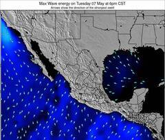
Énergie de Vague (puissance): 12h


Punta San Jacinto (Shipwrecks) Surf:
Monday, 20 July 2026, 20:57 Local time| Lun | Mar | |||
| 8PM | 11PM | 2AM | 5AM | |
| Wave (m) | ||||
| Période (s) | 16 | 16 | 16 | 16 |
| Vent (km/h) | ||||
| Etat du vent | cross | cross | cross | cross- off |
- /breaks/Punta-San-Jacinto/forecasts/latest
Punta San Jacinto (Shipwrecks) Surf Guide
Punta San Jacinto (Shipwrecks) in Baja Norte is an exposed point break that has dependable surf. Winter is the best time of year for surfing here. Offshore winds blow from the northeast. Groundswells more frequent than windswells and the optimum swell angle is from the west. Best around high tide. It very rarely gets crowded here. Take care not to hit part of the wreck here.
Punta San Jacinto (Shipwrecks) Spot Info
Type: Rating: Reliability: Todays Sea Temp*:  Point
Point 2
2consistent 20.0°C*ocean temperature recorded from satelliteSurfing Punta San Jacinto (Shipwrecks):
The best conditions reported for surf at Punta San Jacinto (Shipwrecks) occur when a West swell combines with an offshore wind direction from the Northeast.
Énergie de Vague (puissance): 12h
Utilisez les onglets ci-dessus pour voir la température de la mer à Punta San Jacinto (Shipwrecks), photos pour Punta San Jacinto (Shipwrecks), prévisions de houle détaillées pour Punta San Jacinto (Shipwrecks), prévisions de vent et météo, webcams pour Punta San Jacinto (Shipwrecks), conditions de vents en temps réel à partir des données de la station météo de Baja Norte et prévisions des marées pour Punta San Jacinto (Shipwrecks). Les cartes de houle pour Mexico afficheront une image agrandie de Mexico et des ses mers environnantes. Ces cartes de houles peuvent êtres animées pour montrer les différents composantes de houle, la hauteur, la période et l'énergie des vagues avec les prévisions météo et prévisions de vent. Des observations en temps réel du temps et de l'état de la mer sont fournies grâce aux bouées marines de Mexico, des navires de passages, et des stations météo côtières. Toutes les pages de prévisions pour ce spot de surf ont un Vagu-o-Mètre Local et Global pour facilement trouver les meilleurs spot de surf à proximité de Punta San Jacinto (Shipwrecks).
Punta San Jacinto (Shipwrecks) Surf:
Monday, 20 July 2026, 20:57 Local timeLun Mar 8PM 11PM 2AM 5AM Wave (m) Période (s) 16 16 16 16 Vent (km/h) Etat du vent cross cross cross cross-
off- /breaks/Punta-San-Jacinto/forecasts/latest
- /breaks/Punta-San-Jacinto/forecasts/latest/six_day
Punta San Jacinto (Shipwrecks) Surf Guide
Punta San Jacinto (Shipwrecks) in Baja Norte is an exposed point break that has dependable surf. Winter is the best time of year for surfing here. Offshore winds blow from the northeast. Groundswells more frequent than windswells and the optimum swell angle is from the west. Best around high tide. It very rarely gets crowded here. Take care not to hit part of the wreck here.
Punta San Jacinto (Shipwrecks) Spot Info
Type: Rating: Reliability: Todays Sea Temp*: Point2consistent 20.0°C*ocean temperature recorded from satelliteSurfing Punta San Jacinto (Shipwrecks):
The best conditions reported for surf at Punta San Jacinto (Shipwrecks) occur when a West swell combines with an offshore wind direction from the Northeast.
Énergie de Vague (puissance): 12h
Utilisez les onglets ci-dessus pour voir la température de la mer à Punta San Jacinto (Shipwrecks), photos pour Punta San Jacinto (Shipwrecks), prévisions de houle détaillées pour Punta San Jacinto (Shipwrecks), prévisions de vent et météo, webcams pour Punta San Jacinto (Shipwrecks), conditions de vents en temps réel à partir des données de la station météo de Baja Norte et prévisions des marées pour Punta San Jacinto (Shipwrecks). Les cartes de houle pour Mexico afficheront une image agrandie de Mexico et des ses mers environnantes. Ces cartes de houles peuvent êtres animées pour montrer les différents composantes de houle, la hauteur, la période et l'énergie des vagues avec les prévisions météo et prévisions de vent. Des observations en temps réel du temps et de l'état de la mer sont fournies grâce aux bouées marines de Mexico, des navires de passages, et des stations météo côtières. Toutes les pages de prévisions pour ce spot de surf ont un Vagu-o-Mètre Local et Global pour facilement trouver les meilleurs spot de surf à proximité de Punta San Jacinto (Shipwrecks).
Punta San Jacinto (Shipwrecks) Surf:
Monday, 20 July 2026, 20:57 Local timeLun Mar 8PM 11PM 2AM 5AM Wave (m) Période (s) 16 16 16 16 Vent (km/h) Etat du vent cross cross cross cross-
off- /breaks/Punta-San-Jacinto/forecasts/latest
Punta San Jacinto (Shipwrecks) Surf Guide
Punta San Jacinto (Shipwrecks) in Baja Norte is an exposed point break that has dependable surf. Winter is the best time of year for surfing here. Offshore winds blow from the northeast. Groundswells more frequent than windswells and the optimum swell angle is from the west. Best around high tide. It very rarely gets crowded here. Take care not to hit part of the wreck here.
Punta San Jacinto (Shipwrecks) Spot Info
Type: Rating: Reliability: Todays Sea Temp*: Point2consistent 20.0°C*ocean temperature recorded from satelliteSurfing Punta San Jacinto (Shipwrecks):
The best conditions reported for surf at Punta San Jacinto (Shipwrecks) occur when a West swell combines with an offshore wind direction from the Northeast.
Énergie de Vague (puissance): 12h
Utilisez les onglets ci-dessus pour voir la température de la mer à Punta San Jacinto (Shipwrecks), photos pour Punta San Jacinto (Shipwrecks), prévisions de houle détaillées pour Punta San Jacinto (Shipwrecks), prévisions de vent et météo, webcams pour Punta San Jacinto (Shipwrecks), conditions de vents en temps réel à partir des données de la station météo de Baja Norte et prévisions des marées pour Punta San Jacinto (Shipwrecks). Les cartes de houle pour Mexico afficheront une image agrandie de Mexico et des ses mers environnantes. Ces cartes de houles peuvent êtres animées pour montrer les différents composantes de houle, la hauteur, la période et l'énergie des vagues avec les prévisions météo et prévisions de vent. Des observations en temps réel du temps et de l'état de la mer sont fournies grâce aux bouées marines de Mexico, des navires de passages, et des stations météo côtières. Toutes les pages de prévisions pour ce spot de surf ont un Vagu-o-Mètre Local et Global pour facilement trouver les meilleurs spot de surf à proximité de Punta San Jacinto (Shipwrecks).
Punta San Jacinto (Shipwrecks) Surf:
Monday, 20 July 2026, 20:57 Local timeLun Mar 8PM 11PM 2AM 5AM Wave (m) Période (s) 16 16 16 16 Vent (km/h) Etat du vent cross cross cross cross-
offTide Times:
Pour Camalu, %{dist} %{km} de %{location}.
PROCHAIN EST A (heure locale) il reste marée haute marée basse Punta San Jacinto (Shipwrecks) Tide Times and Tide Chart
Live Weather:
At lightning 29km S of Progreso, 172 km from Punta San Jacinto (Shipwrecks).

ThunderstormAir temperature
°COverall Punta San Jacinto (Shipwrecks) Surf Consistency and Wind Distribution in Juillet


Surf stats for Punta San Jacinto (Shipwrecks): see the swell variation by month.

Wind stats for Punta San Jacinto (Shipwrecks): see the variation in direction and stength by month.
Photos de Surf
de la galerieContours: Routes et Rivières: Sélectionnez un spot de surf du menu 


Utilisez cette carte en relief pour naviguer vers les spots de surf de Baja Norte, et les stations de marées aux alentours de Punta San Jacinto (Shipwrecks)
Spots de Surf les plus proches de Punta San Jacinto (Shipwrecks):
(Cliquez sur le nom du spot pour plus de détails)- Closest spot1 mi
- Second closest spot1 mi
- Third closest spot2 mi
- Fourth closest spot2 mi
- Fifth closest spot9 mi
Bouées marines les plus proches de Punta San Jacinto (Shipwrecks):
- Closest Bouées marines134 mi
- Second closest Bouées marines139 mi
- Third closest Bouées marines154 mi
- Fourth closest Bouées marines155 mi
- Fifth closest Bouées marines155 mi
Stations de marée les plus proches de Punta San Jacinto (Shipwrecks):
- Closest station de maréeCamalu4 mi
- Second closest station de maréeSan Quintin27 mi
- Third closest station de maréeEnsenada76 mi
- Fourth closest station de maréeSan Felipe76 mi
- Fifth closest station de maréeEl Sauzal80 mi
Airports
- The nearest passenger airport to Punta San Jacinto (Shipwrecks) is General Alberto L Salinas C International (Ensenada) Airport (ESE) in Mexico, which is 115 km (71 miles) away (directly).
- The second closest airport to Punta San Jacinto (Shipwrecks) is General Abelardo L Rodriguez International (Tijuana) Airport (TIJ), also in Mexico, 205 km (127 miles) away.
- /breaks/Punta-San-Jacinto/forecasts/latest

 Nearest