
Poverty Beach Surf Guide
Poverty Beach in New Jersey is an exposed beach and reef break Works best in offshore winds from the north northwest. Windswells and groundswells in equal measure and the ideal swell direction is from the south southeast. The beach breaks offer lefts and rights. The quality of the surf isn't affected by the tide. Likely to be crowded if working. Beware of rips, man-made danger (buoys etc..) and locals.
Poverty Beach Spot Info
| Type: | Rating: | Reliability: | Todays Sea Temp*: |
|---|---|---|---|
| rarely breaks | 24.3°C*ocean temperature recorded from satellite |
Surfing Poverty Beach:
The best conditions reported for surf at Poverty Beach occur when a South-southeast swell combines with an offshore wind direction from the North-northwest.
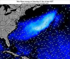
Énergie de Vague (puissance): 12h

Poverty Beach Surf:
Monday, 20 July 2026, 22:10 Local time| Lun | Mardi 21 | |||
| 11PM | 2AM | 5AM | 8AM | |
| Wave (m) | ||||
| Période (s) | 3 | 4 | 4 | 5 |
| Vent (km/h) | ||||
| Etat du vent | on | on | on | on |
- /breaks/Poverty-Beach/forecasts/latest
Poverty Beach Surf Guide
Poverty Beach in New Jersey is an exposed beach and reef break Works best in offshore winds from the north northwest. Windswells and groundswells in equal measure and the ideal swell direction is from the south southeast. The beach breaks offer lefts and rights. The quality of the surf isn't affected by the tide. Likely to be crowded if working. Beware of rips, man-made danger (buoys etc..) and locals.
Poverty Beach Spot Info
Type: Rating: Reliability: Todays Sea Temp*:  Beach and reef
 3
3rarely breaks 24.3°C*ocean temperature recorded from satelliteSurfing Poverty Beach:
The best conditions reported for surf at Poverty Beach occur when a South-southeast swell combines with an offshore wind direction from the North-northwest.
Énergie de Vague (puissance): 12h
Utilisez les onglets ci-dessus pour voir la température de la mer à Poverty Beach, photos pour Poverty Beach, prévisions de houle détaillées pour Poverty Beach, prévisions de vent et météo, webcams pour Poverty Beach, conditions de vents en temps réel à partir des données de la station météo de New Jersey et prévisions des marées pour Poverty Beach. Les cartes de houle pour United States afficheront une image agrandie de United States et des ses mers environnantes. Ces cartes de houles peuvent êtres animées pour montrer les différents composantes de houle, la hauteur, la période et l'énergie des vagues avec les prévisions météo et prévisions de vent. Des observations en temps réel du temps et de l'état de la mer sont fournies grâce aux bouées marines de United States, des navires de passages, et des stations météo côtières. Toutes les pages de prévisions pour ce spot de surf ont un Vagu-o-Mètre Local et Global pour facilement trouver les meilleurs spot de surf à proximité de Poverty Beach.
Poverty Beach Surf:
Monday, 20 July 2026, 22:10 Local timeLun Mardi 21 11PM 2AM 5AM 8AM Wave (m) Période (s) 3 4 4 5 Vent (km/h) Etat du vent on on on on - /breaks/Poverty-Beach/forecasts/latest
- /breaks/Poverty-Beach/forecasts/latest/six_day
Poverty Beach Surf Guide
Poverty Beach in New Jersey is an exposed beach and reef break Works best in offshore winds from the north northwest. Windswells and groundswells in equal measure and the ideal swell direction is from the south southeast. The beach breaks offer lefts and rights. The quality of the surf isn't affected by the tide. Likely to be crowded if working. Beware of rips, man-made danger (buoys etc..) and locals.
Poverty Beach Spot Info
Type: Rating: Reliability: Todays Sea Temp*: Beach and reef3rarely breaks 24.3°C*ocean temperature recorded from satelliteSurfing Poverty Beach:
The best conditions reported for surf at Poverty Beach occur when a South-southeast swell combines with an offshore wind direction from the North-northwest.
Énergie de Vague (puissance): 12h
Utilisez les onglets ci-dessus pour voir la température de la mer à Poverty Beach, photos pour Poverty Beach, prévisions de houle détaillées pour Poverty Beach, prévisions de vent et météo, webcams pour Poverty Beach, conditions de vents en temps réel à partir des données de la station météo de New Jersey et prévisions des marées pour Poverty Beach. Les cartes de houle pour United States afficheront une image agrandie de United States et des ses mers environnantes. Ces cartes de houles peuvent êtres animées pour montrer les différents composantes de houle, la hauteur, la période et l'énergie des vagues avec les prévisions météo et prévisions de vent. Des observations en temps réel du temps et de l'état de la mer sont fournies grâce aux bouées marines de United States, des navires de passages, et des stations météo côtières. Toutes les pages de prévisions pour ce spot de surf ont un Vagu-o-Mètre Local et Global pour facilement trouver les meilleurs spot de surf à proximité de Poverty Beach.
Poverty Beach Surf:
Monday, 20 July 2026, 22:10 Local timeLun Mardi 21 11PM 2AM 5AM 8AM Wave (m) Période (s) 3 4 4 5 Vent (km/h) Etat du vent on on on on - /breaks/Poverty-Beach/forecasts/latest
Poverty Beach Surf Guide
Poverty Beach in New Jersey is an exposed beach and reef break Works best in offshore winds from the north northwest. Windswells and groundswells in equal measure and the ideal swell direction is from the south southeast. The beach breaks offer lefts and rights. The quality of the surf isn't affected by the tide. Likely to be crowded if working. Beware of rips, man-made danger (buoys etc..) and locals.
Poverty Beach Spot Info
Type: Rating: Reliability: Todays Sea Temp*: Beach and reef3rarely breaks 24.3°C*ocean temperature recorded from satelliteSurfing Poverty Beach:
The best conditions reported for surf at Poverty Beach occur when a South-southeast swell combines with an offshore wind direction from the North-northwest.
Énergie de Vague (puissance): 12h
Utilisez les onglets ci-dessus pour voir la température de la mer à Poverty Beach, photos pour Poverty Beach, prévisions de houle détaillées pour Poverty Beach, prévisions de vent et météo, webcams pour Poverty Beach, conditions de vents en temps réel à partir des données de la station météo de New Jersey et prévisions des marées pour Poverty Beach. Les cartes de houle pour United States afficheront une image agrandie de United States et des ses mers environnantes. Ces cartes de houles peuvent êtres animées pour montrer les différents composantes de houle, la hauteur, la période et l'énergie des vagues avec les prévisions météo et prévisions de vent. Des observations en temps réel du temps et de l'état de la mer sont fournies grâce aux bouées marines de United States, des navires de passages, et des stations météo côtières. Toutes les pages de prévisions pour ce spot de surf ont un Vagu-o-Mètre Local et Global pour facilement trouver les meilleurs spot de surf à proximité de Poverty Beach.
Poverty Beach Surf:
Monday, 20 July 2026, 22:10 Local timeLun Mardi 21 11PM 2AM 5AM 8AM Wave (m) Période (s) 3 4 4 5 Vent (km/h) Etat du vent on on on on Tide Times:
Pour Cape May Harbor, New Jersey, %{dist} %{km} de %{location}.
PROCHAIN EST A (heure locale) il reste marée haute marée basse Poverty Beach Tide Times and Tide Chart
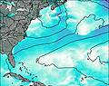
Live Weather:
At BUOY-CMAN4, 7 km from Poverty Beach.
light winds from the SE
(km/h)Air temperature
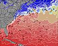
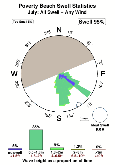
23.9°COverall Poverty Beach Surf Consistency and Wind Distribution in Juillet


Wind stats for Poverty Beach: see the variation in direction and stength by month.
Photos de Surf
de la galerieContours: Routes et Rivières: Sélectionnez un spot de surf du menu 

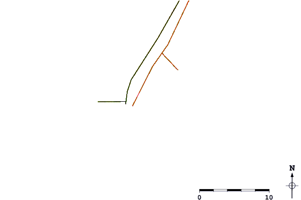
Utilisez cette carte en relief pour naviguer vers les spots de surf de New Jersey, et les stations de marées aux alentours de Poverty Beach
Spots de Surf les plus proches de Poverty Beach:
(Cliquez sur le nom du spot pour plus de détails)- Closest spot1 mi
- Second closest spot1 mi
- Third closest spot2 mi
- Fourth closest spot2 mi
- Fifth closest spot3 mi
Bouées marines les plus proches de Poverty Beach:
- Closest Bouées marines35 mi
- Second closest Bouées marines59 mi
- Third closest Bouées marines82 mi
- Fourth closest Bouées marines83 mi
- Fifth closest Bouées marines85 mi
Stations de marée les plus proches de Poverty Beach:
- Closest station de maréeCape May Harbor1 mi
- Second closest station de maréeCape Island Creek, Cape May2 mi
- Third closest station de maréeCape May, Atlantic Ocean3 mi
- Fourth closest station de maréeSwain Channel, Taylor Sound3 mi
- Fifth closest station de maréeWildwood Crest, ocean pier4 mi
Airports
- The closest passenger airport to Poverty Beach is Cape May Co (Wildwood) Airport (WWD) in USA, 8 km (5 miles) away (directly).
- The second nearest airport to Poverty Beach is Millville Muni Airport (MIV), also in USA, 50 km (31 miles) away.
- Third is Dover Afb Airport (DOV) in USA, 55 km (34 miles) away.
- Atlantic City International Airport (ACY) in USA is 63 km (39 miles) away.
- Salisbury Ocean City Wicomico Rgnl Airport (SBY), also in USA is the fifth nearest airport to Poverty Beach and is 86 km (53 miles) away.

- /breaks/Poverty-Beach/forecasts/latest


 Nearest