

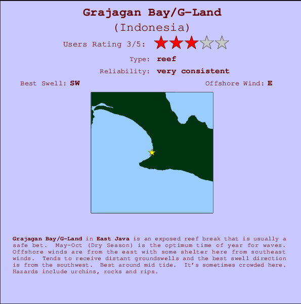
Grajagan Bay/G-Land Surf Guide
Grajagan Bay/G-Land in East Java is an exposed reef break that has very consistent waves. May-Oct (Dry Season) is the optimum time of year for waves. Offshore winds are from the east with some shelter here from southeast winds. Most of the surf here comes from groundswells and the best swell direction is from the southwest. A left hand reef break. Best around mid tide. When it's working here, it can get crowded. Beware of urchins, rocks and rips.
Grajagan Bay/G-Land Spot Info
| Type: | Rating: | Reliability: | Todays Sea Temp*: |
|---|---|---|---|
| very consistent | 26.1°C*ocean temperature recorded from satellite |
Surfing Grajagan Bay/G-Land:
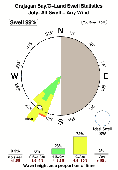
The best conditions reported for surf at Grajagan Bay/G-Land occur when a Southwest swell combines with an offshore wind direction from the East.

Énergie de Vague (puissance): 12h


Grajagan Bay/G-Land Surf:
Thursday, 16 July 2026, 13:50 Local time| Jeudi 16 | ||||
| 4AM | 7AM | 10AM | 1PM | |
| Wave (m) | ||||
| Période (s) | 15 | 15 | 15 | 15 |
| Vent (km/h) | ||||
| Etat du vent | off | off | cross- off |
cross- off |
- /breaks/Grajagan-Bay/forecasts/latest
Grajagan Bay/G-Land Surf Guide
Grajagan Bay/G-Land in East Java is an exposed reef break that has very consistent waves. May-Oct (Dry Season) is the optimum time of year for waves. Offshore winds are from the east with some shelter here from southeast winds. Most of the surf here comes from groundswells and the best swell direction is from the southwest. A left hand reef break. Best around mid tide. When it's working here, it can get crowded. Beware of urchins, rocks and rips.
Grajagan Bay/G-Land Spot Info
Type: Rating: Reliability: Todays Sea Temp*:  Reef
Reef 3
3very consistent 26.1°C*ocean temperature recorded from satelliteSurfing Grajagan Bay/G-Land:
The best conditions reported for surf at Grajagan Bay/G-Land occur when a Southwest swell combines with an offshore wind direction from the East.
Énergie de Vague (puissance): 12h
Utilisez les onglets ci-dessus pour voir la température de la mer à Grajagan Bay/G-Land, photos pour Grajagan Bay/G-Land, prévisions de houle détaillées pour Grajagan Bay/G-Land, prévisions de vent et météo, webcams pour Grajagan Bay/G-Land, conditions de vents en temps réel à partir des données de la station météo de Java - East et prévisions des marées pour Grajagan Bay/G-Land. Les cartes de houle pour Indonesia afficheront une image agrandie de Indonesia et des ses mers environnantes. Ces cartes de houles peuvent êtres animées pour montrer les différents composantes de houle, la hauteur, la période et l'énergie des vagues avec les prévisions météo et prévisions de vent. Des observations en temps réel du temps et de l'état de la mer sont fournies grâce aux bouées marines de Indonesia, des navires de passages, et des stations météo côtières. Toutes les pages de prévisions pour ce spot de surf ont un Vagu-o-Mètre Local et Global pour facilement trouver les meilleurs spot de surf à proximité de Grajagan Bay/G-Land.
Grajagan Bay/G-Land Surf:
Thursday, 16 July 2026, 13:50 Local timeJeudi 16 4AM 7AM 10AM 1PM Wave (m) Période (s) 15 15 15 15 Vent (km/h) Etat du vent off off cross-
offcross-
off- /breaks/Grajagan-Bay/forecasts/latest
- /breaks/Grajagan-Bay/forecasts/latest/six_day
Grajagan Bay/G-Land Surf Guide
Grajagan Bay/G-Land in East Java is an exposed reef break that has very consistent waves. May-Oct (Dry Season) is the optimum time of year for waves. Offshore winds are from the east with some shelter here from southeast winds. Most of the surf here comes from groundswells and the best swell direction is from the southwest. A left hand reef break. Best around mid tide. When it's working here, it can get crowded. Beware of urchins, rocks and rips.
Grajagan Bay/G-Land Spot Info
Type: Rating: Reliability: Todays Sea Temp*: Reef3very consistent 26.1°C*ocean temperature recorded from satelliteSurfing Grajagan Bay/G-Land:
The best conditions reported for surf at Grajagan Bay/G-Land occur when a Southwest swell combines with an offshore wind direction from the East.
Énergie de Vague (puissance): 12h
Utilisez les onglets ci-dessus pour voir la température de la mer à Grajagan Bay/G-Land, photos pour Grajagan Bay/G-Land, prévisions de houle détaillées pour Grajagan Bay/G-Land, prévisions de vent et météo, webcams pour Grajagan Bay/G-Land, conditions de vents en temps réel à partir des données de la station météo de Java - East et prévisions des marées pour Grajagan Bay/G-Land. Les cartes de houle pour Indonesia afficheront une image agrandie de Indonesia et des ses mers environnantes. Ces cartes de houles peuvent êtres animées pour montrer les différents composantes de houle, la hauteur, la période et l'énergie des vagues avec les prévisions météo et prévisions de vent. Des observations en temps réel du temps et de l'état de la mer sont fournies grâce aux bouées marines de Indonesia, des navires de passages, et des stations météo côtières. Toutes les pages de prévisions pour ce spot de surf ont un Vagu-o-Mètre Local et Global pour facilement trouver les meilleurs spot de surf à proximité de Grajagan Bay/G-Land.
Grajagan Bay/G-Land Surf:
Thursday, 16 July 2026, 13:50 Local timeJeudi 16 4AM 7AM 10AM 1PM Wave (m) Période (s) 15 15 15 15 Vent (km/h) Etat du vent off off cross-
offcross-
off- /breaks/Grajagan-Bay/forecasts/latest
Grajagan Bay/G-Land Surf Guide
Grajagan Bay/G-Land in East Java is an exposed reef break that has very consistent waves. May-Oct (Dry Season) is the optimum time of year for waves. Offshore winds are from the east with some shelter here from southeast winds. Most of the surf here comes from groundswells and the best swell direction is from the southwest. A left hand reef break. Best around mid tide. When it's working here, it can get crowded. Beware of urchins, rocks and rips.
Grajagan Bay/G-Land Spot Info
Type: Rating: Reliability: Todays Sea Temp*: Reef3very consistent 26.1°C*ocean temperature recorded from satelliteSurfing Grajagan Bay/G-Land:
The best conditions reported for surf at Grajagan Bay/G-Land occur when a Southwest swell combines with an offshore wind direction from the East.
Énergie de Vague (puissance): 12h
Utilisez les onglets ci-dessus pour voir la température de la mer à Grajagan Bay/G-Land, photos pour Grajagan Bay/G-Land, prévisions de houle détaillées pour Grajagan Bay/G-Land, prévisions de vent et météo, webcams pour Grajagan Bay/G-Land, conditions de vents en temps réel à partir des données de la station météo de Java - East et prévisions des marées pour Grajagan Bay/G-Land. Les cartes de houle pour Indonesia afficheront une image agrandie de Indonesia et des ses mers environnantes. Ces cartes de houles peuvent êtres animées pour montrer les différents composantes de houle, la hauteur, la période et l'énergie des vagues avec les prévisions météo et prévisions de vent. Des observations en temps réel du temps et de l'état de la mer sont fournies grâce aux bouées marines de Indonesia, des navires de passages, et des stations météo côtières. Toutes les pages de prévisions pour ce spot de surf ont un Vagu-o-Mètre Local et Global pour facilement trouver les meilleurs spot de surf à proximité de Grajagan Bay/G-Land.
Grajagan Bay/G-Land Surf:
Thursday, 16 July 2026, 13:50 Local timeJeudi 16 4AM 7AM 10AM 1PM Wave (m) Période (s) 15 15 15 15 Vent (km/h) Etat du vent off off cross-
offcross-
offTide Times:
À Grajagan Bay/G-Land (0 km).
PROCHAIN EST A (heure locale) il reste marée haute marée basse Grajagan Bay/G-Land Tide Times and Tide Chart
Live Weather:
At Bali International Airport, 87 km from Grajagan Bay/G-Land.
moderate winds from the ESE
(km/h)Air temperature
30°COverall Grajagan Bay/G-Land Surf Consistency and Wind Distribution in Juillet


Wind stats for Grajagan Bay/G-Land: see the variation in direction and stength by month.
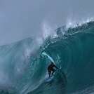
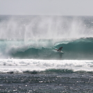
Photos de Surf
de la galerieContours: Routes et Rivières: Sélectionnez un spot de surf du menu 


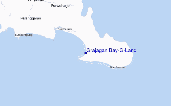
Utilisez cette carte en relief pour naviguer vers les spots de surf de Java - East, et les stations de marées aux alentours de Grajagan Bay/G-Land
Spots de Surf les plus proches de Grajagan Bay/G-Land:
(Cliquez sur le nom du spot pour plus de détails)- Closest spot10 mi
- Second closest spot36 mi
- Third closest spot43 mi
- Fourth closest spot49 mi
- Fifth closest spot49 mi
Bouées marines les plus proches de Grajagan Bay/G-Land:
- Closest Bouées marines1874 mi
- Second closest Bouées marines2182 mi
- Third closest Bouées marines2304 mi
- Fourth closest Bouées marines2354 mi
- Fifth closest Bouées marines2379 mi
Stations de marée les plus proches de Grajagan Bay/G-Land:
- Closest station de maréeWongsorejo50 mi
- Second closest station de maréeBanjar54 mi
- Third closest station de maréeDenpasar58 mi
- Fourth closest station de maréeSingaraja66 mi
- Fifth closest station de maréePanji71 mi
Airports
- The nearest passenger airport to Grajagan Bay/G-Land is Bali International (Denpasar) Airport (DPS) in Indonesia, which is 87 km (54 miles) away (directly).
- The second closest airport to Grajagan Bay/G-Land is Selaparang (Mataram) Airport (AMI), also in Indonesia, 190 km (118 miles) away.
- /breaks/Grajagan-Bay/forecasts/latest


 Nearest