- Forecast
- Maps
- Live
- Weather State
- Spot Information
Prévisions:


Surf à WalkervillePrévision / VIC – East Coast / Australia
Prévisions mises à jour dans hr min s Forecast update imminent
La hauteur de houle à Walkerville est en océan ouvert. Les vagues déferlantes seront souvent plus petites sur des spots moins exposés.
La température de la mer à Walkerville aujourd'hui est
16.7° C
(Ce qui est légèrement plus chaud que d'habitude)Mises à jour dans hr min s Forecast update imminent
Prévision court termePluie modérée (total 10mm), plus lourde le Dim matin. Warm (max 26°C le Ven après-midi, min 12°C le Dim soir). Le vent sera généralement léger. | ||||||||||||||||||||||||
Friday 1 | Saturday 2 | Sunday 3 | Mon 4 | |||||||||||||||||||||
7 AM | 10 AM | 1 PM | 4 PM | 7 PM | 10 PM | 1 AM | 4 AM | 7 AM | 10 AM | 1 PM | 4 PM | 7 PM | 10 PM | 1 AM | 4 AM | 7 AM | 10 AM | 1 PM | 4 PM | 7 PM | 10 PM | 1 AM | 4 AM | |
Carte Hauteur de Houle |  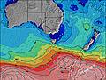  |   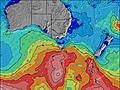 |   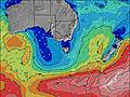 |  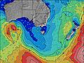 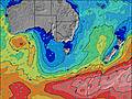 | ||||||||||||||||||||
E 6 | E 6 | ESE 6 | ESE 7 | ENE 7 | E 6 | E 6 | E 6 | E 7 | ENE 7 | ESE 7 | ESE 7 | ESE 7 | ENE 8 | E 8 | E 8 | ESE 8 | E 9 | ESE 9 | ESE 9 | ESE 9 | ESE 9 | ESE 10 | ESE 10 | |
7 | 8 | 4 | 4 | 15 | 3 | 3 | 3 | 4 | 9 | 9 | 10 | 10 | 33 | 30 | 31 | 6 | 40 | 50 | 49 | 32 | 33 | 36 | 35 | |
Vent (km/h) | ||||||||||||||||||||||||
cross-off | cross-off | off | off | cross | cross | cross | cross | cross | cross-off | cross-off | cross-off | cross-off | cross | cross | cross | cross-off | off | cross-off | cross-off | off | off | cross-off | off | |
Marée haute | 11:28AM2.11m | 11:21PM2.17m | 12:39PM2.25m | 00:21AM2.19m | 1:34PM2.38m | 1:12AM2.22m | ||||||||||||||||||
Marée basse | 4:56AM0.62m | 5:22PM0.99m | 5:55AM0.53m | 6:26PM1.01m | 6:46AM0.44m | 7:20PM0.99m | ||||||||||||||||||
6:56 | — | — | — | — | — | — | 6:58 | — | — | — | — | — | — | — | 6:58 | — | — | — | — | — | — | — | 7:00 | |
— | — | — | 5:28 | — | — | — | — | — | — | — | 5:25 | — | — | — | — | — | — | — | 5:24 | — | — | — | 5:23 | |
— | — | — | — | — | — | — | — | — | — | — | — | — | — | — | — | — | — | 4 | 1 | 2 | 1 | 2 | — | |
Temp. °C | 22 | 23 | 25 | 26 | 23 | 23 | 22 | 21 | 21 | 23 | 25 | 24 | 23 | 22 | 21 | 20 | 20 | 18 | 16 | 17 | 15 | 13 | 13 | 13 |
19 | 20 | 22 | 24 | 20 | 19 | 18 | 17 | 17 | 19 | 21 | 19 | 19 | 19 | 17 | 16 | 17 | 16 | 15 | 15 | 12 | 12 | 11 | 10 | |
Houle 1 Hauteur (m) Direction Période (s) | WSW 14 | WSW 14 | WSW 14 | WSW 14 | WSW 14 | WSW 14 | WSW 14 | WSW 13 | WSW 13 | WSW 13 | WSW 13 | WSW 13 | WSW 13 | WSW 13 | WSW 14 | WSW 14 | WSW 13 | WSW 14 | WSW 15 | WSW 14 | WSW 14 | WSW 14 | WSW 13 | W 13 |
431 | 431 | 425 | 425 | 419 | 402 | 384 | 342 | 277 | 277 | 273 | 225 | 225 | 229 | 239 | 236 | 229 | 236 | 334 | 549 | 874 | 1224 | 1179 | 1318 | |
Houle 2 Hauteur (m) Direction Période (s) | E 6 | E 6 | ESE 6 | NW 4 | WNW 4 | WNW 4 | E 4 | E 4 | E 4 | E 6 | ESE 7 | ESE 7 | ESE 7 | ESE 8 | ESE 8 | ESE 8 | E 5 | E 9 | ESE 9 | ESE 9 | ESE 9 | ESE 9 | ESE 10 | ESE 10 |
7 | 7 | 4 | 2 | 1 | 1 | 3 | 3 | 1 | 7 | 9 | 10 | 10 | 11 | 11 | 12 | 4 | 40 | 50 | 49 | 32 | 33 | 36 | 35 | |
Swell 3 Hauteur (m) Direction Période (s) | — | — | — | ESE 7 | ESE 7 | E 6 | E 6 | E 6 | E 7 | — | W 8 | — | — | NW 4 | — | W 8 | ESE 8 | — | NW 4 | — | — | — | — | — |
— | — | — | 4 | 4 | 3 | 3 | 3 | 4 | — | 12 | — | — | 1 | — | 1 | 6 | — | 1 | — | — | — | — | — | |
Vagues de vent Hauteur (m) Direction Période (s) | ENE 5 | ENE 6 | NW 3 | — | ENE 7 | — | — | ENE 4 | ENE 4 | ENE 7 | NNW 3 | NNW 3 | NNW 4 | ENE 8 | E 8 | E 8 | N 4 | NNW 4 | — | WNW 4 | — | — | — | W 4 |
6 | 8 | 2 | — | 15 | — | — | 3 | 3 | 9 | 1 | 2 | 5 | 33 | 30 | 31 | 1 | 2 | — | 6 | — | — | — | 10 | |
Vent de Terre ou Glassy les Plus Proches | ||||||||||||||||||||||||
Distance (km) | 10 | 10 | 10 | 10 | 10 | 11 | 11 | 11 | 11 | 11 | 10 | 10 | 11 | 11 | 11 | 11 | 10 | 10 | 10 | 10 | 35 | 10 | 10 | 11 |
Meilleures Vagues Prévues à East Coast of Victoria | ||||||||||||||||||||||||
Meilleures Vagues Prévues à Australia | ||||||||||||||||||||||||
Header Global | ||||||||||||||||||||||||
- Map Icons:
 Break
Break Live Wave Height (m)
 Live Wind Speed (km/h)
 Surf Rating (10 Max)
 Ocean Swells (m)
- Wind Speed (km/h)
GRATUIT ! Un widget Surf-Forecast.com pour votre site web
Ce widget gratuit de surf report et prévision météo est disponible pour intégrer dans vos sites web et vous donne un résumé de nos prévisions de surf pour Walkerville. Il vous suffit de copier le code HTML et de le coller dans votre site. Vous pouvez choisir votre langue préférée ainsi que les unités de mesures (métrique ou impériale) pour les prévisions pour adapter aux utilisateurs de votre site. Cliquez ici pour obtenir le code.
 Nearest