- Forecast
- Maps
- Live
- Weather State
- Spot Information
Trestraou Prévisions de Surf
/ Brittany – Cote d'Armor (9 surf breaks) /Prévisions:

Surf à TrestraouPrévision / Brittany – Cote d'Armor / France
Prévisions mises à jour dans hr min s Forecast update imminent
La hauteur de houle à Trestraou est en océan ouvert. Les vagues déferlantes seront souvent plus petites sur des spots moins exposés.
La température de la mer à Trestraou aujourd'hui est
12.1° C
(Ce qui est 1.0°C plus chaud que la normale pour cette période de l'année)Mises à jour dans hr min s Forecast update imminent
Prévision court termeGénéralement sec. Very mild (max 17°C le Jeu après-midi, min 8°C le Jeu matin). Vents s'atténuant (vents frais venant de E le Jeu matin, vents légers venant de ESE le Sam matin). | ||||||||||||||||||||||||
Wed 22 | Thursday 23 | Friday 24 | Sat 25 | |||||||||||||||||||||
5 PM | 8 PM | 11 PM | 2 AM | 5 AM | 8 AM | 11 AM | 2 PM | 5 PM | 8 PM | 11 PM | 2 AM | 5 AM | 8 AM | 11 AM | 2 PM | 5 PM | 8 PM | 11 PM | 2 AM | 5 AM | 8 AM | 11 AM | 2 PM | |
Carte Hauteur de Houle |   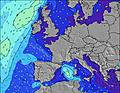 |    |    |   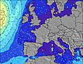 | ||||||||||||||||||||
WNW 13 | WNW 12 | WNW 12 | WNW 12 | ENE 6 | ENE 6 | ENE 6 | WSW 10 | ENE 6 | WSW 10 | WSW 9 | WSW 10 | WSW 11 | WSW 12 | WSW 11 | ENE 6 | WSW 11 | WSW 11 | WSW 11 | WSW 10 | WSW 10 | WSW 11 | WSW 11 | WSW 11 | |
63 | 28 | 28 | 14 | 136 | 162 | 193 | 78 | 136 | 72 | 68 | 51 | 126 | 183 | 173 | 121 | 123 | 123 | 121 | 86 | 112 | 126 | 121 | 117 | |
Vent (km/h) | ||||||||||||||||||||||||
cross-on | cross | cross | cross | cross | cross | cross | cross | cross-on | cross | cross | cross | cross | cross | cross | cross-on | cross-on | cross-on | cross | cross | cross | cross | cross | cross-on | |
Marée haute | 11:07PM6.73m | 11:44AM6.18m | 00:12AM6.15m | 1:03PM5.64m | 1:38AM5.75m | |||||||||||||||||||
Marée basse | 5:04PM1.09m | 5:36AM1.17m | 6:01PM1.75m | 6:42AM1.77m | 7:15PM2.27m | 8:08AM2.12m | ||||||||||||||||||
— | — | — | — | 7:07 | — | — | — | — | — | — | — | 7:07 | — | — | — | — | — | — | — | 7:05 | — | — | — | |
— | 9:15 | — | — | — | — | — | — | — | 9:15 | — | — | — | — | — | — | — | 9:17 | — | — | — | — | — | 9:19 | |
— | — | — | — | — | — | — | — | — | — | — | — | — | — | — | — | — | — | — | — | — | — | — | — | |
Temp. °C | 14 | 14 | 14 | 11 | 10 | 8 | 10 | 14 | 17 | 17 | 15 | 12 | 10 | 10 | 12 | 15 | 16 | 15 | 14 | 14 | 14 | 13 | 14 | 16 |
7 | 9 | 10 | 5 | 4 | 1 | 3 | 7 | 11 | 12 | 10 | 7 | 4 | 4 | 6 | 9 | 11 | 11 | 11 | 11 | 11 | 10 | 11 | 12 | |
Houle 1 Hauteur (m) Direction Période (s) | WNW 13 | WNW 12 | NE 7 | WNW 12 | WNW 11 | WSW 12 | WSW 11 | WSW 10 | WSW 10 | WSW 10 | WSW 9 | WSW 10 | WSW 11 | WSW 12 | WSW 11 | WSW 11 | WSW 11 | WSW 11 | WSW 11 | WSW 10 | NE 5 | NE 5 | WSW 11 | WSW 11 |
63 | 28 | 200 | 14 | 12 | 27 | 66 | 78 | 74 | 72 | 68 | 51 | 126 | 183 | 173 | 121 | 123 | 123 | 121 | 86 | 39 | 27 | 121 | 117 | |
Houle 2 Hauteur (m) Direction Période (s) | — | — | WNW 12 | W 11 | WSW 10 | NW 11 | NW 11 | NW 11 | W 10 | W 10 | W 10 | WSW 11 | — | — | — | — | — | — | — | — | WSW 10 | WSW 11 | ENE 5 | — |
— | — | 28 | 3 | 10 | 5 | 5 | 5 | 2 | 2 | 2 | 43 | — | — | — | — | — | — | — | — | 112 | 126 | 17 | — | |
Swell 3 Hauteur (m) Direction Période (s) | — | — | — | — | — | W 10 | — | — | — | — | — | W 10 | — | — | — | — | — | — | — | — | — | — | — | — |
— | — | — | — | — | 2 | — | — | — | — | — | 2 | — | — | — | — | — | — | — | — | — | — | — | — | |
Vagues de vent Hauteur (m) Direction Période (s) | ENE 7 | NE 7 | — | NE 7 | ENE 6 | ENE 6 | ENE 6 | ENE 6 | ENE 6 | NE 6 | NE 6 | NE 6 | ENE 6 | ENE 6 | ENE 6 | ENE 6 | NE 6 | NE 6 | NE 6 | NE 6 | — | — | — | ENE 5 |
297 | 268 | — | 178 | 136 | 162 | 193 | 179 | 136 | 139 | 162 | 195 | 170 | 159 | 131 | 111 | 80 | 80 | 80 | 59 | — | — | — | 17 | |
Vent de Terre ou Glassy les Plus Proches | ||||||||||||||||||||||||
Distance (km) | 100 | 100 | 106 | 120 | 100 | 95 | 95 | 103 | 100 | 95 | 95 | 95 | 11 | 11 | 95 | 11 | 11 | 93 | 93 | 2 | 2 | 2 | 2 | 93 |
Meilleures Vagues Prévues à Cote d'Armor - Brittany | ||||||||||||||||||||||||
Meilleures Vagues Prévues à France | ||||||||||||||||||||||||
Header Global | ||||||||||||||||||||||||
- Map Icons:
 Break
Break Live Wave Height (m)
 Live Wind Speed (km/h)
 Surf Rating (10 Max)
 Ocean Swells (m)
- Wind Speed (km/h)
GRATUIT ! Un widget Surf-Forecast.com pour votre site web
Ce widget gratuit de surf report et prévision météo est disponible pour intégrer dans vos sites web et vous donne un résumé de nos prévisions de surf pour Trestraou. Il vous suffit de copier le code HTML et de le coller dans votre site. Vous pouvez choisir votre langue préférée ainsi que les unités de mesures (métrique ou impériale) pour les prévisions pour adapter aux utilisateurs de votre site. Cliquez ici pour obtenir le code.
 Nearest