
Smith River and Kellogg Rd Surf Guide
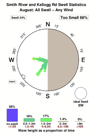
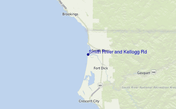
Smith River and Kellogg Road Area in Del Norte County is an exposed beach break that has inconsistent surf with no particular seasonal pattern. Offshore winds are from the east. Clean groundswells prevail and the best swell direction is from the southwest. The beach break provides left and right handers. Surfable at all stages of the tide. It very rarely gets crowded here. Watch out for sharks.
Smith River and Kellogg Rd Spot Info
| Type: | Rating: | Reliability: | Todays Sea Temp*: |
|---|---|---|---|
| inconsistent | 13.5°C*ocean temperature recorded from satellite |
Surfing Smith River and Kellogg Rd:
The best conditions reported for surf at Smith River and Kellogg Rd occur when a Southwest swell combines with an offshore wind direction from the East.

Énergie de Vague (puissance): 12h


Smith River and Kellogg Rd Surf:
Sunday, 2 August 2026, 10:57 Local time| Dimanche 02 | ||||
| 8AM | 11AM | 2PM | 5PM | |
| Wave (m) | ||||
| Période (s) | 7 | 8 | 8 | 8 |
| Vent (km/h) | ||||
| Etat du vent | cross- off |
cross- on |
cross- on |
cross- on |
- /breaks/Smith-River-and-Kellogg-Road-Area/forecasts/latest
Smith River and Kellogg Rd Surf Guide
Smith River and Kellogg Road Area in Del Norte County is an exposed beach break that has inconsistent surf with no particular seasonal pattern. Offshore winds are from the east. Clean groundswells prevail and the best swell direction is from the southwest. The beach break provides left and right handers. Surfable at all stages of the tide. It very rarely gets crowded here. Watch out for sharks.
Smith River and Kellogg Rd Spot Info
Type: Rating: Reliability: Todays Sea Temp*:  Beach
Beach 2
2inconsistent 13.5°C*ocean temperature recorded from satelliteSurfing Smith River and Kellogg Rd:
The best conditions reported for surf at Smith River and Kellogg Rd occur when a Southwest swell combines with an offshore wind direction from the East.
Énergie de Vague (puissance): 12h
Utilisez les onglets ci-dessus pour voir la température de la mer à Smith River and Kellogg Rd, photos pour Smith River and Kellogg Rd, prévisions de houle détaillées pour Smith River and Kellogg Rd, prévisions de vent et météo, webcams pour Smith River and Kellogg Rd, conditions de vents en temps réel à partir des données de la station météo de CAL - Del Norte County et prévisions des marées pour Smith River and Kellogg Rd. Les cartes de houle pour United States afficheront une image agrandie de United States et des ses mers environnantes. Ces cartes de houles peuvent êtres animées pour montrer les différents composantes de houle, la hauteur, la période et l'énergie des vagues avec les prévisions météo et prévisions de vent. Des observations en temps réel du temps et de l'état de la mer sont fournies grâce aux bouées marines de United States, des navires de passages, et des stations météo côtières. Toutes les pages de prévisions pour ce spot de surf ont un Vagu-o-Mètre Local et Global pour facilement trouver les meilleurs spot de surf à proximité de Smith River and Kellogg Rd.
Smith River and Kellogg Rd Surf:
Sunday, 2 August 2026, 10:57 Local timeDimanche 02 8AM 11AM 2PM 5PM Wave (m) Période (s) 7 8 8 8 Vent (km/h) Etat du vent cross-
offcross-
oncross-
oncross-
on- /breaks/Smith-River-and-Kellogg-Road-Area/forecasts/latest
- /breaks/Smith-River-and-Kellogg-Road-Area/forecasts/latest/six_day
Smith River and Kellogg Rd Surf Guide
Smith River and Kellogg Road Area in Del Norte County is an exposed beach break that has inconsistent surf with no particular seasonal pattern. Offshore winds are from the east. Clean groundswells prevail and the best swell direction is from the southwest. The beach break provides left and right handers. Surfable at all stages of the tide. It very rarely gets crowded here. Watch out for sharks.
Smith River and Kellogg Rd Spot Info
Type: Rating: Reliability: Todays Sea Temp*: Beach2inconsistent 13.5°C*ocean temperature recorded from satelliteSurfing Smith River and Kellogg Rd:
The best conditions reported for surf at Smith River and Kellogg Rd occur when a Southwest swell combines with an offshore wind direction from the East.
Énergie de Vague (puissance): 12h
Utilisez les onglets ci-dessus pour voir la température de la mer à Smith River and Kellogg Rd, photos pour Smith River and Kellogg Rd, prévisions de houle détaillées pour Smith River and Kellogg Rd, prévisions de vent et météo, webcams pour Smith River and Kellogg Rd, conditions de vents en temps réel à partir des données de la station météo de CAL - Del Norte County et prévisions des marées pour Smith River and Kellogg Rd. Les cartes de houle pour United States afficheront une image agrandie de United States et des ses mers environnantes. Ces cartes de houles peuvent êtres animées pour montrer les différents composantes de houle, la hauteur, la période et l'énergie des vagues avec les prévisions météo et prévisions de vent. Des observations en temps réel du temps et de l'état de la mer sont fournies grâce aux bouées marines de United States, des navires de passages, et des stations météo côtières. Toutes les pages de prévisions pour ce spot de surf ont un Vagu-o-Mètre Local et Global pour facilement trouver les meilleurs spot de surf à proximité de Smith River and Kellogg Rd.
Smith River and Kellogg Rd Surf:
Sunday, 2 August 2026, 10:57 Local timeDimanche 02 8AM 11AM 2PM 5PM Wave (m) Période (s) 7 8 8 8 Vent (km/h) Etat du vent cross-
offcross-
oncross-
oncross-
on- /breaks/Smith-River-and-Kellogg-Road-Area/forecasts/latest
Smith River and Kellogg Rd Surf Guide
Smith River and Kellogg Road Area in Del Norte County is an exposed beach break that has inconsistent surf with no particular seasonal pattern. Offshore winds are from the east. Clean groundswells prevail and the best swell direction is from the southwest. The beach break provides left and right handers. Surfable at all stages of the tide. It very rarely gets crowded here. Watch out for sharks.
Smith River and Kellogg Rd Spot Info
Type: Rating: Reliability: Todays Sea Temp*: Beach2inconsistent 13.5°C*ocean temperature recorded from satelliteSurfing Smith River and Kellogg Rd:
The best conditions reported for surf at Smith River and Kellogg Rd occur when a Southwest swell combines with an offshore wind direction from the East.
Énergie de Vague (puissance): 12h
Utilisez les onglets ci-dessus pour voir la température de la mer à Smith River and Kellogg Rd, photos pour Smith River and Kellogg Rd, prévisions de houle détaillées pour Smith River and Kellogg Rd, prévisions de vent et météo, webcams pour Smith River and Kellogg Rd, conditions de vents en temps réel à partir des données de la station météo de CAL - Del Norte County et prévisions des marées pour Smith River and Kellogg Rd. Les cartes de houle pour United States afficheront une image agrandie de United States et des ses mers environnantes. Ces cartes de houles peuvent êtres animées pour montrer les différents composantes de houle, la hauteur, la période et l'énergie des vagues avec les prévisions météo et prévisions de vent. Des observations en temps réel du temps et de l'état de la mer sont fournies grâce aux bouées marines de United States, des navires de passages, et des stations météo côtières. Toutes les pages de prévisions pour ce spot de surf ont un Vagu-o-Mètre Local et Global pour facilement trouver les meilleurs spot de surf à proximité de Smith River and Kellogg Rd.
Smith River and Kellogg Rd Surf:
Sunday, 2 August 2026, 10:57 Local timeDimanche 02 8AM 11AM 2PM 5PM Wave (m) Période (s) 7 8 8 8 Vent (km/h) Etat du vent cross-
offcross-
oncross-
oncross-
onTide Times:
À Smith River and Kellogg Rd (0 km).
PROCHAIN EST A (heure locale) il reste marée haute marée basse Smith River and Kellogg Rd Tide Times and Tide Chart
Live Weather:
At Crescent City Airport, 16 km from Smith River and Kellogg Rd.
light winds from the N
(km/h)
ClearAir temperature
15.0°CCurrent weather near Smith River and Kellogg Rd
Buoy Data:
At St Georges Buoy, 10 miles from Smith River and Kellogg Rd.
5AM 6AM 7AM 8AM Age des données 4 hr 3 hr 2 hr 1 hr hauteur de la vague (m) 


Période Dominante (s) 7 7 7 7 Overall Smith River and Kellogg Rd Surf Consistency and Wind Distribution in Août
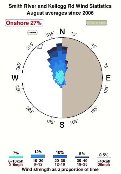


Wind stats for Smith River and Kellogg Rd: see the variation in direction and stength by month.
Photos de Surf
de la galerieContours: Routes et Rivières: Sélectionnez un spot de surf du menu 


Utilisez cette carte en relief pour naviguer vers les spots de surf de CAL - Del Norte County, et les stations de marées aux alentours de Smith River and Kellogg Rd
Spots de Surf les plus proches de Smith River and Kellogg Rd:
(Cliquez sur le nom du spot pour plus de détails)- Closest spot9 mi
- Second closest spot9 mi
- Third closest spot10 mi
- Fourth closest spot10 mi
- Fifth closest spot12 mi
Bouées marines les plus proches de Smith River and Kellogg Rd:
- Closest Bouées marines10 mi
- Second closest Bouées marines66 mi
- Third closest Bouées marines71 mi
- Fourth closest Bouées marines83 mi
- Fifth closest Bouées marines115 mi
Stations de marée les plus proches de Smith River and Kellogg Rd:
- Closest station de maréeBrookings, Chetco Cove10 mi
- Second closest station de maréeCrescent City12 mi
- Third closest station de maréeWedderburn, Rogue River37 mi
- Fourth closest station de maréePort Orford59 mi
- Fifth closest station de maréeTrinidad Harbor60 mi
Airports
- The nearest passenger airport to Smith River and Kellogg Rd is Chico Muni Airport (CIC) in USA, which is 307 km (191 miles) away (directly).
- The second closest airport to Smith River and Kellogg Rd is Mc Minnville Muni (Mackminnville) Airport (MMV), also in USA, 375 km (233 miles) away.

- /breaks/Smith-River-and-Kellogg-Road-Area/forecasts/latest


 Nearest