

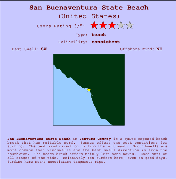
San Buenaventura State Beach Surf Guide
San Buenaventura State Beach in Ventura is a fairly exposed beach break that has reliable surf. Summer offers the best conditions for surfing. Offshore winds blow from the northeast. Tends to receive distant groundswells and the optimum swell angle is from the southwest. Waves at the beach tend to peel to the left. Surfable at all stages of the tide. It very rarely gets crowded here. Dangerous rips are a hazard of surfing here.
San Buenaventura State Beach Spot Info
| Type: | Rating: | Reliability: | Todays Sea Temp*: |
|---|---|---|---|
| consistent | 21.5°C*ocean temperature recorded from satellite |
Surfing San Buenaventura State Beach:
The best conditions reported for surf at San Buenaventura State Beach occur when a Southwest swell combines with an offshore wind direction from the Northeast.

Énergie de Vague (puissance): 12h


San Buenaventura State Beach Surf:
Sunday, 2 August 2026, 08:00 Local time| Dimanche 02 | ||||
| 8AM | 11AM | 2PM | 5PM | |
| Wave (m) | ||||
| Période (s) | 6 | 14 | 9 | 9 |
| Vent (km/h) | ||||
| Etat du vent | glass | on | on | cross- on |
- /breaks/San-Buenaventura-State-Beach/forecasts/latest
San Buenaventura State Beach Surf Guide
San Buenaventura State Beach in Ventura is a fairly exposed beach break that has reliable surf. Summer offers the best conditions for surfing. Offshore winds blow from the northeast. Tends to receive distant groundswells and the optimum swell angle is from the southwest. Waves at the beach tend to peel to the left. Surfable at all stages of the tide. It very rarely gets crowded here. Dangerous rips are a hazard of surfing here.
San Buenaventura State Beach Spot Info
Type: Rating: Reliability: Todays Sea Temp*:  Beach
Beach 3
3consistent 21.5°C*ocean temperature recorded from satelliteSurfing San Buenaventura State Beach:
The best conditions reported for surf at San Buenaventura State Beach occur when a Southwest swell combines with an offshore wind direction from the Northeast.
Énergie de Vague (puissance): 12h
Utilisez les onglets ci-dessus pour voir la température de la mer à San Buenaventura State Beach, photos pour San Buenaventura State Beach, prévisions de houle détaillées pour San Buenaventura State Beach, prévisions de vent et météo, webcams pour San Buenaventura State Beach, conditions de vents en temps réel à partir des données de la station météo de CAL - Ventura et prévisions des marées pour San Buenaventura State Beach. Les cartes de houle pour United States afficheront une image agrandie de United States et des ses mers environnantes. Ces cartes de houles peuvent êtres animées pour montrer les différents composantes de houle, la hauteur, la période et l'énergie des vagues avec les prévisions météo et prévisions de vent. Des observations en temps réel du temps et de l'état de la mer sont fournies grâce aux bouées marines de United States, des navires de passages, et des stations météo côtières. Toutes les pages de prévisions pour ce spot de surf ont un Vagu-o-Mètre Local et Global pour facilement trouver les meilleurs spot de surf à proximité de San Buenaventura State Beach.
San Buenaventura State Beach Surf:
Sunday, 2 August 2026, 08:00 Local timeDimanche 02 8AM 11AM 2PM 5PM Wave (m) Période (s) 6 14 9 9 Vent (km/h) Etat du vent glass on on cross-
on- /breaks/San-Buenaventura-State-Beach/forecasts/latest
- /breaks/San-Buenaventura-State-Beach/forecasts/latest/six_day
San Buenaventura State Beach Surf Guide
San Buenaventura State Beach in Ventura is a fairly exposed beach break that has reliable surf. Summer offers the best conditions for surfing. Offshore winds blow from the northeast. Tends to receive distant groundswells and the optimum swell angle is from the southwest. Waves at the beach tend to peel to the left. Surfable at all stages of the tide. It very rarely gets crowded here. Dangerous rips are a hazard of surfing here.
San Buenaventura State Beach Spot Info
Type: Rating: Reliability: Todays Sea Temp*: Beach3consistent 21.5°C*ocean temperature recorded from satelliteSurfing San Buenaventura State Beach:
The best conditions reported for surf at San Buenaventura State Beach occur when a Southwest swell combines with an offshore wind direction from the Northeast.
Énergie de Vague (puissance): 12h
Utilisez les onglets ci-dessus pour voir la température de la mer à San Buenaventura State Beach, photos pour San Buenaventura State Beach, prévisions de houle détaillées pour San Buenaventura State Beach, prévisions de vent et météo, webcams pour San Buenaventura State Beach, conditions de vents en temps réel à partir des données de la station météo de CAL - Ventura et prévisions des marées pour San Buenaventura State Beach. Les cartes de houle pour United States afficheront une image agrandie de United States et des ses mers environnantes. Ces cartes de houles peuvent êtres animées pour montrer les différents composantes de houle, la hauteur, la période et l'énergie des vagues avec les prévisions météo et prévisions de vent. Des observations en temps réel du temps et de l'état de la mer sont fournies grâce aux bouées marines de United States, des navires de passages, et des stations météo côtières. Toutes les pages de prévisions pour ce spot de surf ont un Vagu-o-Mètre Local et Global pour facilement trouver les meilleurs spot de surf à proximité de San Buenaventura State Beach.
San Buenaventura State Beach Surf:
Sunday, 2 August 2026, 08:00 Local timeDimanche 02 8AM 11AM 2PM 5PM Wave (m) Période (s) 6 14 9 9 Vent (km/h) Etat du vent glass on on cross-
on- /breaks/San-Buenaventura-State-Beach/forecasts/latest
San Buenaventura State Beach Surf Guide
San Buenaventura State Beach in Ventura is a fairly exposed beach break that has reliable surf. Summer offers the best conditions for surfing. Offshore winds blow from the northeast. Tends to receive distant groundswells and the optimum swell angle is from the southwest. Waves at the beach tend to peel to the left. Surfable at all stages of the tide. It very rarely gets crowded here. Dangerous rips are a hazard of surfing here.
San Buenaventura State Beach Spot Info
Type: Rating: Reliability: Todays Sea Temp*: Beach3consistent 21.5°C*ocean temperature recorded from satelliteSurfing San Buenaventura State Beach:
The best conditions reported for surf at San Buenaventura State Beach occur when a Southwest swell combines with an offshore wind direction from the Northeast.
Énergie de Vague (puissance): 12h
Utilisez les onglets ci-dessus pour voir la température de la mer à San Buenaventura State Beach, photos pour San Buenaventura State Beach, prévisions de houle détaillées pour San Buenaventura State Beach, prévisions de vent et météo, webcams pour San Buenaventura State Beach, conditions de vents en temps réel à partir des données de la station météo de CAL - Ventura et prévisions des marées pour San Buenaventura State Beach. Les cartes de houle pour United States afficheront une image agrandie de United States et des ses mers environnantes. Ces cartes de houles peuvent êtres animées pour montrer les différents composantes de houle, la hauteur, la période et l'énergie des vagues avec les prévisions météo et prévisions de vent. Des observations en temps réel du temps et de l'état de la mer sont fournies grâce aux bouées marines de United States, des navires de passages, et des stations météo côtières. Toutes les pages de prévisions pour ce spot de surf ont un Vagu-o-Mètre Local et Global pour facilement trouver les meilleurs spot de surf à proximité de San Buenaventura State Beach.
San Buenaventura State Beach Surf:
Sunday, 2 August 2026, 08:00 Local timeDimanche 02 8AM 11AM 2PM 5PM Wave (m) Période (s) 6 14 9 9 Vent (km/h) Etat du vent glass on on cross-
onTide Times:
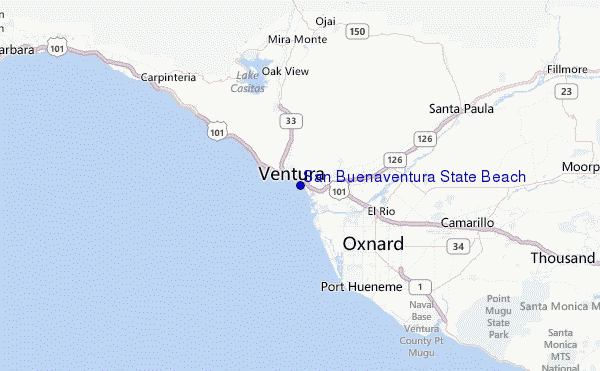
À Ventura, California (0 km).
PROCHAIN EST A (heure locale) il reste marée haute marée basse San Buenaventura State Beach Tide Times and Tide Chart
Live Weather:
At Oxnard Airport, 11 km from San Buenaventura State Beach.
calm
(km/h)
Mist -Air temperature
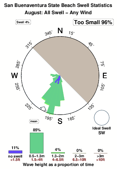
18.9°COverall San Buenaventura State Beach Surf Consistency and Wind Distribution in Août
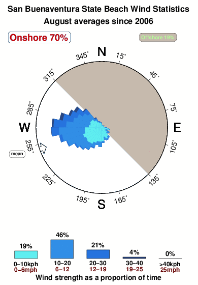


Wind stats for San Buenaventura State Beach: see the variation in direction and stength by month.
Photos de Surf
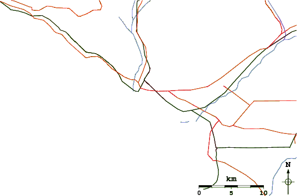
de la galerieContours: Routes et Rivières: Sélectionnez un spot de surf du menu 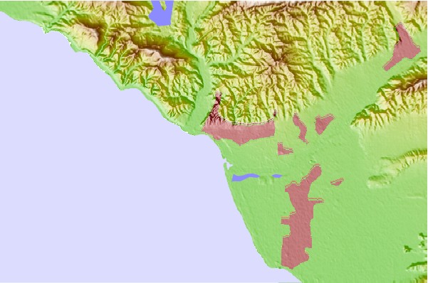
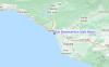
Utilisez cette carte en relief pour naviguer vers les spots de surf de CAL - Ventura, et les stations de marées aux alentours de San Buenaventura State Beach
Spots de Surf les plus proches de San Buenaventura State Beach:
(Cliquez sur le nom du spot pour plus de détails)- Closest spot1 mi
- Second closest spot2 mi
- Third closest spot2 mi
- Fourth closest spot2 mi
- Fifth closest spot2 mi
Bouées marines les plus proches de San Buenaventura State Beach:
- Closest Bouées marines11 mi
- Second closest Bouées marines32 mi
- Third closest Bouées marines39 mi
- Fourth closest Bouées marines39 mi
- Fifth closest Bouées marines42 mi
Stations de marée les plus proches de San Buenaventura State Beach:
- Closest station de maréeVentura0 mi
- Second closest station de maréeOxnard Shores6 mi
- Third closest station de maréeOxnard9 mi
- Fourth closest station de maréePort Hueneme9 mi
- Fifth closest station de maréeRincon Island11 mi
Airports
- The closest passenger airport to San Buenaventura State Beach is Point Mugu Nas Airport (NTD) in USA, 22 km (14 miles) away (directly).
- The second nearest airport to San Buenaventura State Beach is Burbank Glendale Pasadena Airport (BUR), also in USA, 85 km (53 miles) away.
- Third is Los Angeles International Airport (LAX) in USA, 88 km (55 miles) away.
- Jack Northrop Fld Hawthorne Muni Airport (HHR) in USA is 95 km (59 miles) away.
- Long Beach Airport (LGB), also in USA is the fifth nearest airport to San Buenaventura State Beach and is 116 km (72 miles) away.
- /breaks/San-Buenaventura-State-Beach/forecasts/latest
 Nearest