

- Forecast
- Maps
- Live
- Weather State
- Spot Information
Salinas Surf Forecast
/ Rio Grande Do Sul (19 surf breaks) /
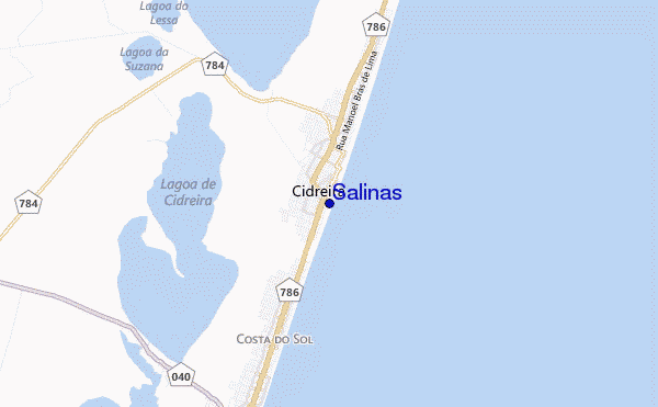
Salinas surf Forecast / Rio Grande Do Sul / Brazil
- Map Icons:
 Break
Break Live Wave Height (m)
 Live Wind Speed (km/h)
 Surf Rating (10 Max)
 Ocean Swells (m)
- Wind Speed (km/h)
How big are the waves at Salinas today?
The current surf forecast for Salinas at 10PM is: 0.5m 12s primary swell from a South direction and 0.5m 10s secondary swell from a Southeast direction (forecast issued at 08:00pm April 26). An open ocean swell of 1.9m 7s is not directed at the surf break. The wind direction is predicted to be cross-onshore.
| Time (-03) & Date | Wave Height | Wave Period |
|---|---|---|
| Morning (26 Apr) | - | - |
| Afternoon (26 Apr) | - | - |
| Evening (26 Apr) | 1.5ft (0.5m) | 12s |
Table - waves today at Salinas. (Swell directed towards the surf break)
Fri 26 | Saturday 27 | Sunday 28 | Monday 29 | Tuesday 30 | Wednesday 01 | Thursday 02 | Friday 03 | Sat 04 | ||||||||||||||||||||||||||||||||||||||||||||||||||||
| 6 PM | 9 PM | 0 AM | 3 AM | 6 AM | 9 AM | 12 PM | 3 PM | 6 PM | 9 PM | 0 AM | 3 AM | 6 AM | 9 AM | 12 PM | 3 PM | 6 PM | 9 PM | 0 AM | 3 AM | 6 AM | 9 AM | 12 PM | 3 PM | 6 PM | 9 PM | 0 AM | 3 AM | 6 AM | 9 AM | 12 PM | 3 PM | 6 PM | 9 PM | 0 AM | 3 AM | 6 AM | 9 AM | 12 PM | 3 PM | 6 PM | 9 PM | 0 AM | 3 AM | 6 AM | 9 AM | 12 PM | 3 PM | 6 PM | 9 PM | 0 AM | 3 AM | 6 AM | 9 AM | 12 PM | 3 PM | 6 PM | 9 PM | 0 AM | 3 AM | |
Rating (10 max) | ||||||||||||||||||||||||||||||||||||||||||||||||||||||||||||
Swell Height Map |    |    |    |    |    |    |  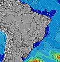 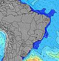 |  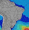 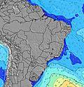 | 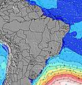 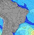 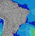 | |||||||||||||||||||||||||||||||||||||||||||||||||||
| Wave Height (m) & direction (?) | ||||||||||||||||||||||||||||||||||||||||||||||||||||||||||||
| Period(s) (?) | 9 | 12 | 12 | 7 | 7 | 7 | 7 | 7 | 7 | 7 | 7 | 8 | 8 | 8 | 8 | 7 | 7 | 7 | 9 | 9 | 10 | 10 | 11 | 10 | 6 | 6 | 6 | 7 | 7 | 7 | 7 | 7 | 8 | 8 | 7 | 7 | 7 | 7 | 7 | 7 | 7 | 7 | 7 | 7 | 7 | 7 | 6 | 7 | 7 | 7 | 7 | 7 | 7 | 8 | 13 | 13 | 12 | 12 | 12 | 12 |
Wave (?)Graph | ||||||||||||||||||||||||||||||||||||||||||||||||||||||||||||
| Energy (?) | 77 | 72 | 98 | 250 | 178 | 138 | 138 | 108 | 111 | 93 | 284 | 449 | 395 | 303 | 214 | 140 | 93 | 124 | 131 | 173 | 188 | 162 | 150 | 143 | 147 | 153 | 186 | 189 | 200 | 258 | 222 | 228 | 226 | 234 | 220 | 160 | 128 | 128 | 111 | 109 | 89 | 94 | 91 | 89 | 72 | 72 | 178 | 297 | 240 | 258 | 311 | 220 | 176 | 287 | 759 | 747 | 690 | 672 | 556 | 472 |
Wind (km/h) | ||||||||||||||||||||||||||||||||||||||||||||||||||||||||||||
| Wind State (?) onshore cross-onshore cross-shore cross-offshore offshore glassy | cross- on | cross- on | cross- on | cross | cross- off | cross | cross- off | cross- off | cross- off | cross- off | cross | cross | cross | cross | cross- on | on | on | on | cross- on | cross- on | cross- on | cross- on | cross- on | cross- on | cross- on | cross- on | cross- on | cross- on | glass | glass | cross- on | on | on | cross- on | cross- on | cross- on | glass | cross- off | cross- off | cross- off | cross- off | cross- off | cross- off | cross- off | cross- off | off | cross- off | cross- off | cross- off | cross- off | cross- off | cross- off | cross- off | cross- off | cross- on | cross- on | cross- on | on | on | cross- on |
High Tide / height (m) | 6:57PM 0.37 | 1:52AM 0.40 | 7:49AM 0.14 | 2:51PM 0.47 | 8:07PM 0.42 | 2:22AM 0.38 | 8:45AM 0.15 | 3:32PM 0.43 | 9:04PM 0.48 | 2:52AM 0.37 | 9:33AM 0.18 | 4:18PM 0.36 | 9:57PM 0.54 | 3:21AM 0.35 | 10:17AM 0.21 | 5:17PM 0.29 | 10:48PM 0.59 | 3:38AM 0.34 | 10:59AM 0.25 | 11:39PM 0.62 | 11:40AM 0.28 | 12:30AM 0.62 | 12:22PM 0.31 | 1:22AM 0.59 | ||||||||||||||||||||||||||||||||||||
Low Tide / height (m) | 5:38PM 0.36 | 10:35PM 0.22 | 6:04AM 0.11 | 10:18AM 0.08 | 5:44PM 0.36 | 11:30PM 0.26 | 6:25AM 0.09 | 11:13AM 0.08 | 6:00PM 0.35 | 12:31AM 0.30 | 6:53AM 0.08 | 12:14PM 0.09 | 6:18PM 0.32 | 1:40AM 0.32 | 7:24AM 0.09 | 1:19PM 0.08 | 6:29PM 0.28 | 3:09AM 0.33 | 7:59AM 0.11 | 2:28PM 0.06 | 8:36AM 0.15 | 3:40PM 0.03 | 9:16AM 0.20 | 4:49PM 0.01 | ||||||||||||||||||||||||||||||||||||
Fri 26 | Saturday 27 | Sunday 28 | Monday 29 | Tuesday 30 | Wednesday 01 | Thursday 02 | Friday 03 | Sat 04 | ||||||||||||||||||||||||||||||||||||||||||||||||||||
| Sunrise | - | - | - | - | - | 6:47 | - | - | - | - | - | - | - | 6:48 | - | - | - | - | - | - | - | 6:48 | - | - | - | - | - | - | - | 6:48 | - | - | - | - | - | - | - | 6:50 | - | - | - | - | - | - | - | 6:50 | - | - | - | - | - | - | - | 6:50 | - | - | - | - | - | - |
| Sunset | - | - | - | - | - | - | - | 5:47 | - | - | - | - | - | - | - | 5:46 | - | - | - | - | - | - | - | 5:45 | - | - | - | - | - | - | - | 5:45 | - | - | - | - | - | - | - | 5:44 | - | - | - | - | - | - | - | 5:44 | - | - | - | - | - | - | - | 5:43 | - | - | - | - |
Rain (mm) | 7 | 2 | - | - | - | - | - | - | 1 | 3 | 3 | 2 | 1 | 1 | - | - | - | 2 | 1 | 1 | 1 | 1 | 1 | 3 | 3 | 3 | 1 | 3 | 3 | 3 | 1 | - | 2 | 2 | 2 | 1 | 3 | 3 | 9 | 5 | 3 | 1 | 4 | 8 | 5 | 10 | 2 | 3 | 3 | 2 | - | - | - | - | - | - | 2 | 6 | 7 | 4 |
| Temp. °C | 22 | 22 | 23 | 23 | 23 | 24 | 30 | 31 | 26 | 21 | 19 | 18 | 17 | 17 | 18 | 19 | 19 | 19 | 19 | 20 | 20 | 20 | 21 | 21 | 22 | 22 | 22 | 22 | 22 | 22 | 24 | 23 | 23 | 22 | 22 | 22 | 22 | 22 | 22 | 22 | 22 | 22 | 21 | 21 | 21 | 21 | 21 | 20 | 19 | 17 | 17 | 17 | 17 | 16 | 17 | 17 | 15 | 15 | 16 | 17 |
| Feels °C (?) | 22 | 23 | 25 | 25 | 25 | 26 | 32 | 34 | 26 | 22 | 17 | 17 | 16 | 15 | 18 | 19 | 19 | 18 | 17 | 18 | 20 | 18 | 20 | 21 | 22 | 22 | 22 | 22 | 26 | 26 | 26 | 25 | 25 | 23 | 23 | 24 | 25 | 25 | 22 | 22 | 22 | 25 | 23 | 24 | 22 | 23 | 22 | 18 | 16 | 15 | 15 | 15 | 15 | 14 | 15 | 15 | 13 | 13 | 14 | 15 |
FREE! Surf-Forecast.com widget for your website
The surf report / weather widget below is available to embed on third party websites free of charge and provides a summary of our Salinas surf forecast. Simply grab the html code snippet that we provide and paste it into your own site. You can choose your preferred language and metric/imperial units for the surf forecast feed to suit users of your site. Click here to get the code.


 Nearest