- Forecast
- Maps
- Live
- Weather State
- Spot Information

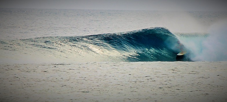
Surf à MajesticsPrévision / Catanduanes / Philippines
Jeu 03 | Vendredi 04 | Samedi 05 | Dimanche 06 | Lundi 07 | Mardi 08 | Mercredi 09 | Jeudi 10 | Vendredi 11 | Samedi 12 | Dimanche 13 | Lundi 14 | Mar 15 | ||||||||||||||||||||||||
| après- midi | soir | matin | après- midi | soir | matin | après- midi | soir | matin | après- midi | soir | matin | après- midi | soir | matin | après- midi | soir | matin | après- midi | soir | matin | après- midi | soir | matin | après- midi | soir | matin | après- midi | soir | matin | après- midi | soir | matin | après- midi | soir | matin | |
Notation (10 max) | ||||||||||||||||||||||||||||||||||||
Carte Hauteur de Houle |  |  |  | 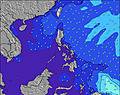 | 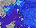 | 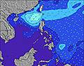 | 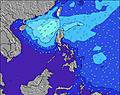 | 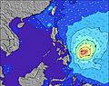 | 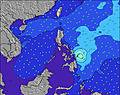 | 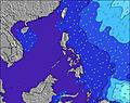 | 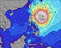 | 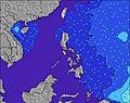 | 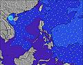 | |||||||||||||||||||||||
| Hauteur de Vagues (m) & direction (?) | ||||||||||||||||||||||||||||||||||||
| Période(s) (?) | 11 | 10 | 10 | 10 | 10 | 10 | 10 | 9 | 9 | 10 | 9 | 9 | 10 | 10 | 10 | 10 | 10 | 9 | 8 | 11 | 11 | 11 | 11 | 10 | 10 | 10 | 10 | 10 | 15 | 13 | 12 | 10 | 10 | 10 | 10 | 10 |
Graphique (?)Vague | ||||||||||||||||||||||||||||||||||||
| Énergie (?) | 65 | 74 | 90 | 83 | 70 | 74 | 72 | 56 | 69 | 61 | 57 | 46 | 47 | 50 | 50 | 51 | 48 | 51 | 75 | 72 | 58 | 51 | 51 | 52 | 39 | 39 | 55 | 74 | 167 | 147 | 92 | 62 | 63 | 62 | 60 | 68 |
Vent (km/h) | ||||||||||||||||||||||||||||||||||||
| Etat du vent (?) onshore Vent de Mer-Latéral Latéral Vent de Terre-Latéral Vent de Terre Mer d'Huile | cross- off | glass | off | off | off | off | cross- off | off | off | off | cross- off | off | cross- off | cross- off | cross- off | cross- off | cross- off | cross- off | cross- off | cross- off | off | off | cross- off | off | off | off | off | off | cross- off | off | cross- off | cross- off | off | cross- off | off | off |
Marée haute / hauteur (m) | 11:53PM 1.51 | 12:50PM 1.26 | 12:45AM 1.50 | 2:14PM 1.27 | 1:39AM 1.51 | 3:24PM 1.32 | 2:32AM 1.55 | 4:17PM 1.40 | 3:22AM 1.61 | 5:00PM 1.47 | 4:07AM 1.67 | 5:38PM 1.53 | 4:49AM 1.74 | 6:13PM 1.59 | 5:29AM 1.80 | 6:47PM 1.63 | 6:08AM 1.84 | 7:21PM 1.66 | 6:47AM 1.85 | 7:54PM 1.69 | 7:28AM 1.82 | 8:28PM 1.70 | 8:12AM 1.75 | |||||||||||||
Marée basse / hauteur (m) | 5:19PM 0.75 | 6:37AM 0.69 | 6:16PM 0.86 | 7:43AM 0.63 | 7:23PM 0.92 | 8:43AM 0.54 | 8:30PM 0.94 | 9:33AM 0.44 | 9:27PM 0.93 | 10:18AM 0.34 | 10:15PM 0.89 | 10:59AM 0.25 | 10:58PM 0.84 | 11:37AM 0.17 | 11:37PM 0.78 | 12:14PM 0.12 | 12:15AM 0.73 | 12:50PM 0.10 | 12:53AM 0.68 | 1:26PM 0.11 | 1:33AM 0.64 | 2:02PM 0.16 | 2:16AM 0.60 | |||||||||||||
Jeu 03 | Vendredi 04 | Samedi 05 | Dimanche 06 | Lundi 07 | Mardi 08 | Mercredi 09 | Jeudi 10 | Vendredi 11 | Samedi 12 | Dimanche 13 | Lundi 14 | Mar 15 | ||||||||||||||||||||||||
| Lever du soleil | - | - | 5:18 | - | - | 5:18 | - | - | 5:18 | - | - | 5:20 | - | - | 5:20 | - | - | 5:20 | - | - | 5:20 | - | - | 5:20 | - | - | 5:20 | - | - | 5:20 | - | - | 5:22 | - | - | 5:22 |
| Coucher du soleil | 6:14 | - | - | 6:14 | - | - | 6:14 | - | - | 6:14 | - | - | 6:14 | - | - | 6:14 | - | - | 6:14 | - | - | 6:14 | - | - | 6:14 | - | - | 6:14 | - | - | 6:14 | - | - | 6:14 | - | - |
Pluie (mm) | 3 | 5 | - | - | 4 | - | 1 | 1 | - | - | 2 | - | - | - | - | - | 1 | - | - | - | - | - | - | - | 1 | - | - | - | 1 | - | - | - | - | - | - | - |
| Temp. °C | 31 | 28 | 29 | 30 | 28 | 30 | 31 | 28 | 30 | 31 | 29 | 30 | 31 | 29 | 31 | 31 | 29 | 30 | 31 | 28 | 30 | 31 | 28 | 30 | 31 | 28 | 30 | 31 | 29 | 30 | 31 | 28 | 30 | 32 | 29 | 30 |
| Feels °C (?) | 33 | 32 | 31 | 32 | 31 | 32 | 33 | 31 | 31 | 33 | 33 | 32 | 33 | 32 | 33 | 33 | 32 | 32 | 33 | 30 | 31 | 32 | 30 | 30 | 32 | 30 | 31 | 32 | 32 | 31 | 32 | 31 | 31 | 33 | 32 | 31 |
Prévision court terme: Pluie modérée (total 14mm), plus lourde le Jeu après-midi. Warm (max 31°C le Jeu après-midi, min 27°C le Jeu soir). Le vent sera généralement léger. | Résumé Météo Jours 3-6 Pluie légère (total 3mm), généralement tombant le Dim soir. Warm (max 31°C le Dim après-midi, min 27°C le Dim soir). Le vent sera généralement léger. | Résumé Météo Jours 6-9 De la bruine, plus lourde pendant Ven après-midi. Warm (max 31°C le Mer après-midi, min 27°C le Mer soir). Le vent sera généralement léger. | Prévision long terme: De la bruine, plus lourde pendant Sam soir. Warm (max 32°C le Lun après-midi, min 27°C le Sam soir). Le vent sera généralement léger. | |||||||||||||||||||||||||||||||||
- Map Icons:
 Break
Break Live Wave Height (m)
 Live Wind Speed (km/h)
 Surf Rating (10 Max)
 Ocean Swells (m)
- Wind Speed (km/h)
Envoyer un Surf Report <i>Eyeball</i> pour Majestics:
Faites partie de notre communauté de reporters de surfGRATUIT ! Un widget Surf-Forecast.com pour votre site web
Ce widget gratuit de surf report et prévision météo est disponible pour intégrer dans vos sites web et vous donne un résumé de nos prévisions de surf pour Majestics. Il vous suffit de copier le code HTML et de le coller dans votre site. Vous pouvez choisir votre langue préférée ainsi que les unités de mesures (métrique ou impériale) pour les prévisions pour adapter aux utilisateurs de votre site. Cliquez ici pour obtenir le code.
Informations sur les prévisions de surf de Majestics
Le tableau de prévision surf ci-dessus pour Majestics fournit les informations essentielles pour déterminer si les conditions de surf seront bonnes durant les 12 prochains jours. Un guide sur le spot de Majestics se trouve sous l'onglet 'Info Spot' (menu du haut). Nos prévisions surf pour Majestics sont uniques car elles fournissent un valeur de l'énergie des vagues (puissance) donnant une meilleure idée de la force réelle des vagues plutôt que seulement leur hauteur ou leur période. Si vous surfez à Majestics régulièrement, faites une note mentale de l'énergie des vagues du tableau de prévisions surf à chaque fois. Vous pourrez rapidement commencer à choisir votre jour de surf sur la seule base de l'énergie des vagues combinée avec nos prévisions de vent. Notre évaluation (nombre allant de 1 à 10 dans les étoiles) vous viendra à l'aide aussi. À part les prédictions habituelles de hauteur et période des vagues, vous trouverez aussi une décomposition complète des éléments de houle dans notre option pour utilisateurs avancés (cliquez le petit personnage d'Einstein sous les marées).
Des infos supplémentaires sur nos prévisions de surf pour Majestics ainsi que des réponses aux questions fréquemment posées se trouvent sous l'onglet d'aide (menu du haut). Des éléments de réponses se trouvent aussi en cliquant sur les points d'interrogation dans le tableau de prévisions. N'oubliez pas de tenir en compte que les prévisions sont en eau libre près des côtes et que des facteurs locaux à chaque spot de surf peuvent influencer la hauteur réelle des vagues déferlantes (profil de la plage ou du récif, profondeur des eaux au large des côtes et abris du vent).
Majestics is 22 km (14 miles) from the city of Virac. If you plan a holiday in Catanduanes, look for hotels and other accommodation in Virac. Virac has rooms for a wide range of budgets as well as car hire and transport links.


 Nearest