

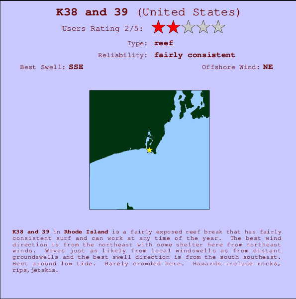
K38 and 39 Surf Guide
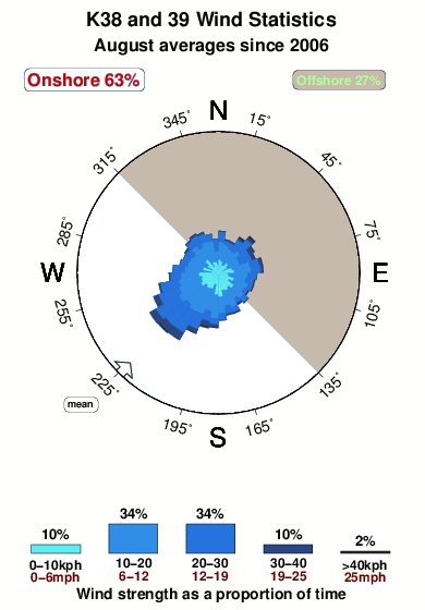
K38and39 in Rhode Island is a fairly exposed reef break that has reasonably consistent surf and can work at any time of the year. Offshore winds are from the northeast with some shelter here from northeast winds. Windswells and groundswells in equal measure and the ideal swell angle is from the south southeast. Primarily a left hand reef break, although a right is also possible.. Best around low tide. Unlikely to be too crowded, even when the surf is up. Beware of rocks, rips,jetskis.
K38 and 39 Spot Info
| Type: | Rating: | Reliability: | Todays Sea Temp*: |
|---|---|---|---|
| fairly consistent | 20.0°C*ocean temperature recorded from satellite |
Surfing K38 and 39:
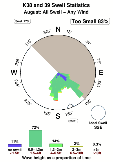
The best conditions reported for surf at K38 and 39 occur when a South-southeast swell combines with an offshore wind direction from the Northeast.

Énergie de Vague (puissance): 12h


K38 and 39 Surf:
Sunday, 2 August 2026, 07:36 Local time| Dimanche 02 | ||||
| 5AM | 8AM | 11AM | 2PM | |
| Wave (m) | ||||
| Période (s) | 8 | 7 | 7 | 7 |
| Vent (km/h) | ||||
| Etat du vent | cross- on |
cross- on |
cross- on |
cross- on |
- /breaks/K-Thirty-Eight-and-Thirty-nine/forecasts/latest
K38 and 39 Surf Guide
K38and39 in Rhode Island is a fairly exposed reef break that has reasonably consistent surf and can work at any time of the year. Offshore winds are from the northeast with some shelter here from northeast winds. Windswells and groundswells in equal measure and the ideal swell angle is from the south southeast. Primarily a left hand reef break, although a right is also possible.. Best around low tide. Unlikely to be too crowded, even when the surf is up. Beware of rocks, rips,jetskis.
K38 and 39 Spot Info
Type: Rating: Reliability: Todays Sea Temp*:  Reef
Reef 2
2fairly consistent 20.0°C*ocean temperature recorded from satelliteSurfing K38 and 39:
The best conditions reported for surf at K38 and 39 occur when a South-southeast swell combines with an offshore wind direction from the Northeast.
Énergie de Vague (puissance): 12h
Utilisez les onglets ci-dessus pour voir la température de la mer à K38 and 39, photos pour K38 and 39, prévisions de houle détaillées pour K38 and 39, prévisions de vent et météo, webcams pour K38 and 39, conditions de vents en temps réel à partir des données de la station météo de Rhode Island et prévisions des marées pour K38 and 39. Les cartes de houle pour United States afficheront une image agrandie de United States et des ses mers environnantes. Ces cartes de houles peuvent êtres animées pour montrer les différents composantes de houle, la hauteur, la période et l'énergie des vagues avec les prévisions météo et prévisions de vent. Des observations en temps réel du temps et de l'état de la mer sont fournies grâce aux bouées marines de United States, des navires de passages, et des stations météo côtières. Toutes les pages de prévisions pour ce spot de surf ont un Vagu-o-Mètre Local et Global pour facilement trouver les meilleurs spot de surf à proximité de K38 and 39.
K38 and 39 Surf:
Sunday, 2 August 2026, 07:36 Local timeDimanche 02 5AM 8AM 11AM 2PM Wave (m) Période (s) 8 7 7 7 Vent (km/h) Etat du vent cross-
oncross-
oncross-
oncross-
on- /breaks/K-Thirty-Eight-and-Thirty-nine/forecasts/latest
- /breaks/K-Thirty-Eight-and-Thirty-nine/forecasts/latest/six_day
K38 and 39 Surf Guide
K38and39 in Rhode Island is a fairly exposed reef break that has reasonably consistent surf and can work at any time of the year. Offshore winds are from the northeast with some shelter here from northeast winds. Windswells and groundswells in equal measure and the ideal swell angle is from the south southeast. Primarily a left hand reef break, although a right is also possible.. Best around low tide. Unlikely to be too crowded, even when the surf is up. Beware of rocks, rips,jetskis.
K38 and 39 Spot Info
Type: Rating: Reliability: Todays Sea Temp*: Reef2fairly consistent 20.0°C*ocean temperature recorded from satelliteSurfing K38 and 39:
The best conditions reported for surf at K38 and 39 occur when a South-southeast swell combines with an offshore wind direction from the Northeast.
Énergie de Vague (puissance): 12h
Utilisez les onglets ci-dessus pour voir la température de la mer à K38 and 39, photos pour K38 and 39, prévisions de houle détaillées pour K38 and 39, prévisions de vent et météo, webcams pour K38 and 39, conditions de vents en temps réel à partir des données de la station météo de Rhode Island et prévisions des marées pour K38 and 39. Les cartes de houle pour United States afficheront une image agrandie de United States et des ses mers environnantes. Ces cartes de houles peuvent êtres animées pour montrer les différents composantes de houle, la hauteur, la période et l'énergie des vagues avec les prévisions météo et prévisions de vent. Des observations en temps réel du temps et de l'état de la mer sont fournies grâce aux bouées marines de United States, des navires de passages, et des stations météo côtières. Toutes les pages de prévisions pour ce spot de surf ont un Vagu-o-Mètre Local et Global pour facilement trouver les meilleurs spot de surf à proximité de K38 and 39.
K38 and 39 Surf:
Sunday, 2 August 2026, 07:36 Local timeDimanche 02 5AM 8AM 11AM 2PM Wave (m) Période (s) 8 7 7 7 Vent (km/h) Etat du vent cross-
oncross-
oncross-
oncross-
on- /breaks/K-Thirty-Eight-and-Thirty-nine/forecasts/latest
K38 and 39 Surf Guide
K38and39 in Rhode Island is a fairly exposed reef break that has reasonably consistent surf and can work at any time of the year. Offshore winds are from the northeast with some shelter here from northeast winds. Windswells and groundswells in equal measure and the ideal swell angle is from the south southeast. Primarily a left hand reef break, although a right is also possible.. Best around low tide. Unlikely to be too crowded, even when the surf is up. Beware of rocks, rips,jetskis.
K38 and 39 Spot Info
Type: Rating: Reliability: Todays Sea Temp*: Reef2fairly consistent 20.0°C*ocean temperature recorded from satelliteSurfing K38 and 39:
The best conditions reported for surf at K38 and 39 occur when a South-southeast swell combines with an offshore wind direction from the Northeast.
Énergie de Vague (puissance): 12h
Utilisez les onglets ci-dessus pour voir la température de la mer à K38 and 39, photos pour K38 and 39, prévisions de houle détaillées pour K38 and 39, prévisions de vent et météo, webcams pour K38 and 39, conditions de vents en temps réel à partir des données de la station météo de Rhode Island et prévisions des marées pour K38 and 39. Les cartes de houle pour United States afficheront une image agrandie de United States et des ses mers environnantes. Ces cartes de houles peuvent êtres animées pour montrer les différents composantes de houle, la hauteur, la période et l'énergie des vagues avec les prévisions météo et prévisions de vent. Des observations en temps réel du temps et de l'état de la mer sont fournies grâce aux bouées marines de United States, des navires de passages, et des stations météo côtières. Toutes les pages de prévisions pour ce spot de surf ont un Vagu-o-Mètre Local et Global pour facilement trouver les meilleurs spot de surf à proximité de K38 and 39.
K38 and 39 Surf:
Sunday, 2 August 2026, 07:36 Local timeDimanche 02 5AM 8AM 11AM 2PM Wave (m) Période (s) 8 7 7 7 Vent (km/h) Etat du vent cross-
oncross-
oncross-
oncross-
onTide Times:
Pour Point Judith Harbor of Refuge, Rhode Island, %{dist} %{km} de %{location}.
PROCHAIN EST A (heure locale) il reste marée haute marée basse K38 and 39 Tide Times and Tide Chart
Live Weather:
At BUOY-NWPR1, 20 km from K38 and 39.
light winds from the S
(km/h)Air temperature
22.1°CCurrent weather near K38 and 39
Buoy Data:
At Block Island, RI, 34 miles from K38 and 39.
2AM 3AM 4AM 5AM Age des données 4 hr 3 hr 2 hr 1 hr hauteur de la vague (m) 


Période Dominante (s) 8 8 8 8 Overall K38 and 39 Surf Consistency and Wind Distribution in Août
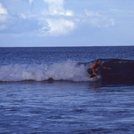
Photos de Surf
de la galerieContours: Routes et Rivières: Sélectionnez un spot de surf du menu 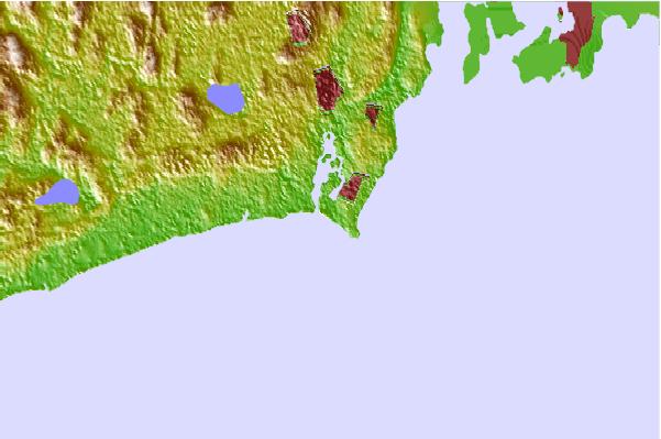
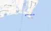
Utilisez cette carte en relief pour naviguer vers les spots de surf de Rhode Island, et les stations de marées aux alentours de K38 and 39
Spots de Surf les plus proches de K38 and 39:
(Cliquez sur le nom du spot pour plus de détails)- Closest spot1 mi
- Second closest spot1 mi
- Third closest spot1 mi
- Fourth closest spot2 mi
- Fifth closest spot2 mi
Bouées marines les plus proches de K38 and 39:
- Closest Bouées marines34 mi
- Second closest Bouées marines55 mi
- Third closest Bouées marines62 mi
- Fourth closest Bouées marines68 mi
- Fifth closest Bouées marines69 mi
Stations de marée les plus proches de K38 and 39:
- Closest station de maréePoint Judith Harbor of Refuge1 mi
- Second closest station de maréeMoonstone Beach2 mi
- Third closest station de maréeNarragansett Pier, Narragansett Bay4 mi
- Fourth closest station de maréeBeavertail Point, Narragansett Bay7 mi
- Fifth closest station de maréeWatson Pier, Boston Neck, Narragansett Bay7 mi
Airports
- The closest passenger airport to K38 and 39 is Theodore Francis Green State (Providence) Airport (PVD) in USA, 40 km (25 miles) away (directly).
- The second nearest airport to K38 and 39 is North Central State (Smithfield) Airport (SFZ), also in USA, 61 km (38 miles) away.
- Third is Otis Angb (Falmouth) Airport (FMH) in USA, 88 km (55 miles) away.
- Hartford Brainard Airport (HFD) in USA is 104 km (65 miles) away.
- The Francis S Gabreski (West Hampton Beach) Airport (FOK), also in USA is the fifth nearest airport to K38 and 39 and is 111 km (69 miles) away.
- /breaks/K-Thirty-Eight-and-Thirty-nine/forecasts/latest


 Nearest