- Forecast
- Maps
- Live
- Weather State
- Spot Information
Ile de Re - Les Grenettes Prévisions de Surf
/ Charente Maritime (28 surf breaks) /Prévisions:

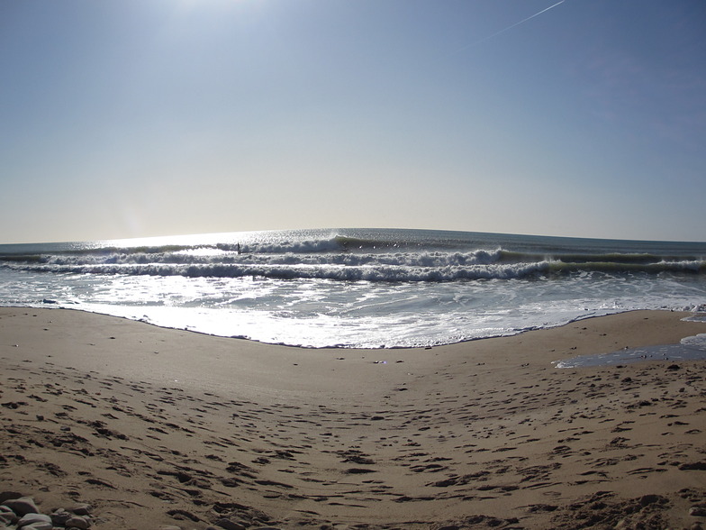
Surf à Ile de Re - Les GrenettesPrévision / Charente Maritime / France
Prévisions mises à jour dans hr min s Forecast update imminent
La hauteur de houle à Ile de Re - Les Grenettes est en océan ouvert. Les vagues déferlantes seront souvent plus petites sur des spots moins exposés.
La température de la mer à Ile de Re - Les Grenettes aujourd'hui est
19.5° C
(Ce qui est normal pour cette période de l'année)Mises à jour dans hr min s Forecast update imminent
Lundi 15 | Mardi 16 | Mercredi 17 | Jeu 18 | |||||||||||||||||||||
| 5 AM | 8 AM | 11 AM | 2 PM | 5 PM | 8 PM | 11 PM | 2 AM | 5 AM | 8 AM | 11 AM | 2 PM | 5 PM | 8 PM | 11 PM | 2 AM | 5 AM | 8 AM | 11 AM | 2 PM | 5 PM | 8 PM | 11 PM | 2 AM | |
Notation (10 max) | ||||||||||||||||||||||||
Carte Hauteur de Houle |    |    |    |    | ||||||||||||||||||||
| Hauteur de Vagues (m) & direction (?) | ||||||||||||||||||||||||
| Période(s) (?) | 9 | 10 | 11 | 11 | 12 | 13 | 13 | 13 | 13 | 13 | 13 | 13 | 13 | 12 | 12 | 12 | 12 | 11 | 11 | 11 | 11 | 10 | 10 | 10 |
Graphique (?)Vague | ||||||||||||||||||||||||
| 631 | 667 | 815 | 1024 | 1335 | 1491 | 2278 | 1421 | 1421 | 1288 | 1121 | 987 | 851 | 679 | 488 | 411 | 333 | 248 | 191 | 149 | 146 | 100 | 69 | 69 | |
Vent (km/h) | ||||||||||||||||||||||||
| Etat du vent (?) onshore Vent de Mer-Latéral Latéral Vent de Terre-Latéral Vent de Terre Mer d'Huile | cross- on | cross- on | cross- on | cross- on | cross- on | cross- on | cross- on | cross- on | cross- on | cross- on | cross- on | cross- on | cross- on | cross- on | cross | glass | glass | cross- off | cross | glass | cross | cross- off | off | off |
Marée haute / hauteur (m) | 12:15PM 3.30 | 1:30AM 3.21 | 2:00PM 3.45 | 2:44AM 3.43 | 3:06PM 3.75 | |||||||||||||||||||
Marée basse / hauteur (m) | 5:44PM 1.13 | 6:18AM 1.35 | 7:07PM 1.19 | 7:39AM 1.29 | 8:26PM 1.01 | |||||||||||||||||||
Lundi 15 | Mardi 16 | Mercredi 17 | Jeu 18 | |||||||||||||||||||||
| Lever du soleil | - | 7:41 | - | - | - | - | - | - | - | 7:43 | - | - | - | - | - | - | - | 7:45 | - | - | - | - | - | - |
| Coucher du soleil | - | - | - | - | - | 8:17 | - | - | - | - | - | - | - | 8:15 | - | - | - | - | - | - | - | 8:14 | - | - |
Pluie (mm) | 1 | - | - | - | - | - | - | - | - | - | - | - | - | - | - | - | - | - | - | - | - | - | - | - |
| Temp. °C | 19 | 18 | 18 | 18 | 18 | 18 | 18 | 17 | 17 | 17 | 17 | 17 | 17 | 17 | 16 | 16 | 16 | 15 | 15 | 17 | 19 | 21 | 21 | 20 |
| Feels °C (?) | 14 | 13 | 13 | 12 | 12 | 12 | 13 | 13 | 13 | 15 | 15 | 15 | 16 | 16 | 15 | 17 | 16 | 14 | 14 | 17 | 18 | 19 | 19 | 18 |
- Map Icons:
 Break
Break Live Wave Height (m)
 Live Wind Speed (km/h)
 Surf Rating (10 Max)
 Ocean Swells (m)
- Wind Speed (km/h)
 Surf Reports Eyeball récent pour Charente Maritime

Expand
<
>
View all
1 h 26 min ago
20 km/h
W
Cross-On
Please reload the page to see if there are any updates.
GRATUIT ! Un widget Surf-Forecast.com pour votre site web
Ce widget gratuit de surf report et prévision météo est disponible pour intégrer dans vos sites web et vous donne un résumé de nos prévisions de surf pour Ile de Re - Les Grenettes. Il vous suffit de copier le code HTML et de le coller dans votre site. Vous pouvez choisir votre langue préférée ainsi que les unités de mesures (métrique ou impériale) pour les prévisions pour adapter aux utilisateurs de votre site. Cliquez ici pour obtenir le code.
 Nearest