
Hazard Canyon Surf Guide
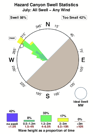
Hazard Canyon in San Luis Obispo is an exposed reef break that has pretty consitent surf. Winter is the optimum time of year for surfing here. The best wind direction is from the southeast. Groundswells more frequent than windswells and the ideal swell direction is from the northwest. Primarily a right hand reef break, although a left is also possible.. Best around mid tide. It's sometimes crowded here. Hazards include rips, rocks, locals and sharks.
Hazard Canyon Spot Info
| Type: | Rating: | Reliability: | Todays Sea Temp*: |
|---|---|---|---|
| fairly consistent | 14.6°C*ocean temperature recorded from satellite |
Surfing Hazard Canyon:
The best conditions reported for surf at Hazard Canyon occur when a Northwest swell combines with an offshore wind direction from the Southeast.

Énergie de Vague (puissance): 12h


Hazard Canyon Surf:
Friday, 31 July 2026, 10:31 Local time| Vendredi 31 | ||||
| 2AM | 5AM | 8AM | 11AM | |
| Wave (m) | ||||
| Période (s) | 8 | 8 | 8 | 7 |
| Vent (km/h) | ||||
| Etat du vent | on | on | on | on |
- /breaks/Hazard-Canyon/forecasts/latest
Hazard Canyon Surf Guide
Hazard Canyon in San Luis Obispo is an exposed reef break that has pretty consitent surf. Winter is the optimum time of year for surfing here. The best wind direction is from the southeast. Groundswells more frequent than windswells and the ideal swell direction is from the northwest. Primarily a right hand reef break, although a left is also possible.. Best around mid tide. It's sometimes crowded here. Hazards include rips, rocks, locals and sharks.
Hazard Canyon Spot Info
Type: Rating: Reliability: Todays Sea Temp*:  Reef
Reef 2
2fairly consistent 14.6°C*ocean temperature recorded from satelliteSurfing Hazard Canyon:
The best conditions reported for surf at Hazard Canyon occur when a Northwest swell combines with an offshore wind direction from the Southeast.
Énergie de Vague (puissance): 12h
Utilisez les onglets ci-dessus pour voir la température de la mer à Hazard Canyon, photos pour Hazard Canyon, prévisions de houle détaillées pour Hazard Canyon, prévisions de vent et météo, webcams pour Hazard Canyon, conditions de vents en temps réel à partir des données de la station météo de CAL - San Luis Obispo et prévisions des marées pour Hazard Canyon. Les cartes de houle pour United States afficheront une image agrandie de United States et des ses mers environnantes. Ces cartes de houles peuvent êtres animées pour montrer les différents composantes de houle, la hauteur, la période et l'énergie des vagues avec les prévisions météo et prévisions de vent. Des observations en temps réel du temps et de l'état de la mer sont fournies grâce aux bouées marines de United States, des navires de passages, et des stations météo côtières. Toutes les pages de prévisions pour ce spot de surf ont un Vagu-o-Mètre Local et Global pour facilement trouver les meilleurs spot de surf à proximité de Hazard Canyon.
Hazard Canyon Surf:
Friday, 31 July 2026, 10:31 Local timeVendredi 31 2AM 5AM 8AM 11AM Wave (m) Période (s) 8 8 8 7 Vent (km/h) Etat du vent on on on on - /breaks/Hazard-Canyon/forecasts/latest
- /breaks/Hazard-Canyon/forecasts/latest/six_day
Hazard Canyon Surf Guide
Hazard Canyon in San Luis Obispo is an exposed reef break that has pretty consitent surf. Winter is the optimum time of year for surfing here. The best wind direction is from the southeast. Groundswells more frequent than windswells and the ideal swell direction is from the northwest. Primarily a right hand reef break, although a left is also possible.. Best around mid tide. It's sometimes crowded here. Hazards include rips, rocks, locals and sharks.
Hazard Canyon Spot Info
Type: Rating: Reliability: Todays Sea Temp*: Reef2fairly consistent 14.6°C*ocean temperature recorded from satelliteSurfing Hazard Canyon:
The best conditions reported for surf at Hazard Canyon occur when a Northwest swell combines with an offshore wind direction from the Southeast.
Énergie de Vague (puissance): 12h
Utilisez les onglets ci-dessus pour voir la température de la mer à Hazard Canyon, photos pour Hazard Canyon, prévisions de houle détaillées pour Hazard Canyon, prévisions de vent et météo, webcams pour Hazard Canyon, conditions de vents en temps réel à partir des données de la station météo de CAL - San Luis Obispo et prévisions des marées pour Hazard Canyon. Les cartes de houle pour United States afficheront une image agrandie de United States et des ses mers environnantes. Ces cartes de houles peuvent êtres animées pour montrer les différents composantes de houle, la hauteur, la période et l'énergie des vagues avec les prévisions météo et prévisions de vent. Des observations en temps réel du temps et de l'état de la mer sont fournies grâce aux bouées marines de United States, des navires de passages, et des stations météo côtières. Toutes les pages de prévisions pour ce spot de surf ont un Vagu-o-Mètre Local et Global pour facilement trouver les meilleurs spot de surf à proximité de Hazard Canyon.
Hazard Canyon Surf:
Friday, 31 July 2026, 10:31 Local timeVendredi 31 2AM 5AM 8AM 11AM Wave (m) Période (s) 8 8 8 7 Vent (km/h) Etat du vent on on on on - /breaks/Hazard-Canyon/forecasts/latest
Hazard Canyon Surf Guide
Hazard Canyon in San Luis Obispo is an exposed reef break that has pretty consitent surf. Winter is the optimum time of year for surfing here. The best wind direction is from the southeast. Groundswells more frequent than windswells and the ideal swell direction is from the northwest. Primarily a right hand reef break, although a left is also possible.. Best around mid tide. It's sometimes crowded here. Hazards include rips, rocks, locals and sharks.
Hazard Canyon Spot Info
Type: Rating: Reliability: Todays Sea Temp*: Reef2fairly consistent 14.6°C*ocean temperature recorded from satelliteSurfing Hazard Canyon:
The best conditions reported for surf at Hazard Canyon occur when a Northwest swell combines with an offshore wind direction from the Southeast.
Énergie de Vague (puissance): 12h
Utilisez les onglets ci-dessus pour voir la température de la mer à Hazard Canyon, photos pour Hazard Canyon, prévisions de houle détaillées pour Hazard Canyon, prévisions de vent et météo, webcams pour Hazard Canyon, conditions de vents en temps réel à partir des données de la station météo de CAL - San Luis Obispo et prévisions des marées pour Hazard Canyon. Les cartes de houle pour United States afficheront une image agrandie de United States et des ses mers environnantes. Ces cartes de houles peuvent êtres animées pour montrer les différents composantes de houle, la hauteur, la période et l'énergie des vagues avec les prévisions météo et prévisions de vent. Des observations en temps réel du temps et de l'état de la mer sont fournies grâce aux bouées marines de United States, des navires de passages, et des stations météo côtières. Toutes les pages de prévisions pour ce spot de surf ont un Vagu-o-Mètre Local et Global pour facilement trouver les meilleurs spot de surf à proximité de Hazard Canyon.
Hazard Canyon Surf:
Friday, 31 July 2026, 10:31 Local timeVendredi 31 2AM 5AM 8AM 11AM Wave (m) Période (s) 8 8 8 7 Vent (km/h) Etat du vent on on on on Tide Times:
Pour Spooners Cove, %{dist} %{km} de %{location}.
PROCHAIN EST A (heure locale) il reste marée haute marée basse Hazard Canyon Tide Times and Tide Chart
Live Weather:
At Diablo Canyon- CA, 10 km from Hazard Canyon.
- Air temperature
-°CCurrent weather near Hazard Canyon
Buoy Data:
At Diablo Canyon, CA, 6 miles from Hazard Canyon.
5AM 6AM 7AM 8AM Age des données 4 hr 3 hr 2 hr 1 hr hauteur de la vague (m) 


Période Dominante (s) 15 7 6 7 Overall Hazard Canyon Surf Consistency and Wind Distribution in Juillet
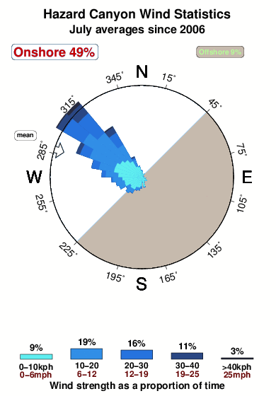


Wind stats for Hazard Canyon: see the variation in direction and stength by month.
Photos de Surf
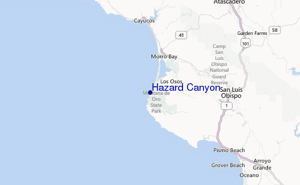
de la galerieContours: Routes et Rivières: Sélectionnez un spot de surf du menu 


Utilisez cette carte en relief pour naviguer vers les spots de surf de CAL - San Luis Obispo, et les stations de marées aux alentours de Hazard Canyon
Spots de Surf les plus proches de Hazard Canyon:
(Cliquez sur le nom du spot pour plus de détails)- Closest spot1 mi
- Second closest spot1 mi
- Third closest spot6 mi
- Fourth closest spot7 mi
- Fifth closest spot9 mi
Bouées marines les plus proches de Hazard Canyon:
- Closest Bouées marines6 mi
- Second closest Bouées marines29 mi
- Third closest Bouées marines40 mi
- Fourth closest Bouées marines58 mi
- Fifth closest Bouées marines58 mi
Stations de marée les plus proches de Hazard Canyon:
- Closest station de maréeMorro Bay6 mi
- Second closest station de maréeMorro Beach, Estero Bay8 mi
- Third closest station de maréePort San Luis11 mi
- Fourth closest station de maréeAvila12 mi
- Fifth closest station de maréeGrover Beach19 mi
Airports
- The closest passenger airport to Hazard Canyon is Vandenberg Afb (Lompoc) Airport (VBG) in USA, 68 km (42 miles) away (directly).
- The second nearest airport to Hazard Canyon is Lemoore Nas Airport (NLC), also in USA, 144 km (89 miles) away.
- Third is Meadows Fld (Bakersfield) Airport (BFL) in USA, 167 km (104 miles) away.
- Fresno Yosemite International Airport (FAT) in USA is 196 km (122 miles) away.
- Point Mugu Nas Airport (NTD), also in USA is the fifth nearest airport to Hazard Canyon and is 207 km (129 miles) away.

- /breaks/Hazard-Canyon/forecasts/latest


 Nearest