

Misquamicut State Beach Surf Guide
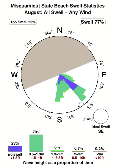
Misquamicut State Beach in Rhode Island is a fairly exposed beach break that is often working and works all around the year. Offshore winds blow from the north northwest. Most of the surf here comes from groundswells and the ideal swell direction is from the southeast. Good surf at all stages of the tide. When the surf is up, crowds are likely
Misquamicut State Beach Spot Info
| Type: | Rating: | Reliability: | Todays Sea Temp*: |
|---|---|---|---|
| very consistent | 20.2°C*ocean temperature recorded from satellite |
Surfing Misquamicut State Beach:
The best conditions reported for surf at Misquamicut State Beach occur when a Southeast swell combines with an offshore wind direction from the North-northwest.

Énergie de Vague (puissance): 12h


Misquamicut State Beach Surf:
Saturday, 1 August 2026, 03:34 Local time| Ven | Samedi 01 | |||
| 11PM | 2AM | 5AM | 8AM | |
| Wave (m) | ||||
| Période (s) | 8 | 8 | 8 | 8 |
| Vent (km/h) | ||||
| Etat du vent | cross | cross | cross- off |
cross |
- /breaks/Misquamicut-State-Beach/forecasts/latest
Misquamicut State Beach Surf Guide
Misquamicut State Beach in Rhode Island is a fairly exposed beach break that is often working and works all around the year. Offshore winds blow from the north northwest. Most of the surf here comes from groundswells and the ideal swell direction is from the southeast. Good surf at all stages of the tide. When the surf is up, crowds are likely
Misquamicut State Beach Spot Info
Type: Rating: Reliability: Todays Sea Temp*:  Beach
Beach 3
3very consistent 20.2°C*ocean temperature recorded from satelliteSurfing Misquamicut State Beach:
The best conditions reported for surf at Misquamicut State Beach occur when a Southeast swell combines with an offshore wind direction from the North-northwest.
Énergie de Vague (puissance): 12h
Utilisez les onglets ci-dessus pour voir la température de la mer à Misquamicut State Beach, photos pour Misquamicut State Beach, prévisions de houle détaillées pour Misquamicut State Beach, prévisions de vent et météo, webcams pour Misquamicut State Beach, conditions de vents en temps réel à partir des données de la station météo de Rhode Island et prévisions des marées pour Misquamicut State Beach. Les cartes de houle pour United States afficheront une image agrandie de United States et des ses mers environnantes. Ces cartes de houles peuvent êtres animées pour montrer les différents composantes de houle, la hauteur, la période et l'énergie des vagues avec les prévisions météo et prévisions de vent. Des observations en temps réel du temps et de l'état de la mer sont fournies grâce aux bouées marines de United States, des navires de passages, et des stations météo côtières. Toutes les pages de prévisions pour ce spot de surf ont un Vagu-o-Mètre Local et Global pour facilement trouver les meilleurs spot de surf à proximité de Misquamicut State Beach.
Misquamicut State Beach Surf:
Saturday, 1 August 2026, 03:34 Local timeVen Samedi 01 11PM 2AM 5AM 8AM Wave (m) Période (s) 8 8 8 8 Vent (km/h) Etat du vent cross cross cross-
offcross - /breaks/Misquamicut-State-Beach/forecasts/latest
- /breaks/Misquamicut-State-Beach/forecasts/latest/six_day
Misquamicut State Beach Surf Guide
Misquamicut State Beach in Rhode Island is a fairly exposed beach break that is often working and works all around the year. Offshore winds blow from the north northwest. Most of the surf here comes from groundswells and the ideal swell direction is from the southeast. Good surf at all stages of the tide. When the surf is up, crowds are likely
Misquamicut State Beach Spot Info
Type: Rating: Reliability: Todays Sea Temp*: Beach3very consistent 20.2°C*ocean temperature recorded from satelliteSurfing Misquamicut State Beach:
The best conditions reported for surf at Misquamicut State Beach occur when a Southeast swell combines with an offshore wind direction from the North-northwest.
Énergie de Vague (puissance): 12h
Utilisez les onglets ci-dessus pour voir la température de la mer à Misquamicut State Beach, photos pour Misquamicut State Beach, prévisions de houle détaillées pour Misquamicut State Beach, prévisions de vent et météo, webcams pour Misquamicut State Beach, conditions de vents en temps réel à partir des données de la station météo de Rhode Island et prévisions des marées pour Misquamicut State Beach. Les cartes de houle pour United States afficheront une image agrandie de United States et des ses mers environnantes. Ces cartes de houles peuvent êtres animées pour montrer les différents composantes de houle, la hauteur, la période et l'énergie des vagues avec les prévisions météo et prévisions de vent. Des observations en temps réel du temps et de l'état de la mer sont fournies grâce aux bouées marines de United States, des navires de passages, et des stations météo côtières. Toutes les pages de prévisions pour ce spot de surf ont un Vagu-o-Mètre Local et Global pour facilement trouver les meilleurs spot de surf à proximité de Misquamicut State Beach.
Misquamicut State Beach Surf:
Saturday, 1 August 2026, 03:34 Local timeVen Samedi 01 11PM 2AM 5AM 8AM Wave (m) Période (s) 8 8 8 8 Vent (km/h) Etat du vent cross cross cross-
offcross - /breaks/Misquamicut-State-Beach/forecasts/latest
Misquamicut State Beach Surf Guide
Misquamicut State Beach in Rhode Island is a fairly exposed beach break that is often working and works all around the year. Offshore winds blow from the north northwest. Most of the surf here comes from groundswells and the ideal swell direction is from the southeast. Good surf at all stages of the tide. When the surf is up, crowds are likely
Misquamicut State Beach Spot Info
Type: Rating: Reliability: Todays Sea Temp*: Beach3very consistent 20.2°C*ocean temperature recorded from satelliteSurfing Misquamicut State Beach:
The best conditions reported for surf at Misquamicut State Beach occur when a Southeast swell combines with an offshore wind direction from the North-northwest.
Énergie de Vague (puissance): 12h
Utilisez les onglets ci-dessus pour voir la température de la mer à Misquamicut State Beach, photos pour Misquamicut State Beach, prévisions de houle détaillées pour Misquamicut State Beach, prévisions de vent et météo, webcams pour Misquamicut State Beach, conditions de vents en temps réel à partir des données de la station météo de Rhode Island et prévisions des marées pour Misquamicut State Beach. Les cartes de houle pour United States afficheront une image agrandie de United States et des ses mers environnantes. Ces cartes de houles peuvent êtres animées pour montrer les différents composantes de houle, la hauteur, la période et l'énergie des vagues avec les prévisions météo et prévisions de vent. Des observations en temps réel du temps et de l'état de la mer sont fournies grâce aux bouées marines de United States, des navires de passages, et des stations météo côtières. Toutes les pages de prévisions pour ce spot de surf ont un Vagu-o-Mètre Local et Global pour facilement trouver les meilleurs spot de surf à proximité de Misquamicut State Beach.
Misquamicut State Beach Surf:
Saturday, 1 August 2026, 03:34 Local timeVen Samedi 01 11PM 2AM 5AM 8AM Wave (m) Période (s) 8 8 8 8 Vent (km/h) Etat du vent cross cross cross-
offcross Tide Times:
Pour Weekapaug Point, Block Island Sound, Rhode Island, %{dist} %{km} de %{location}.
PROCHAIN EST A (heure locale) il reste marée haute marée basse Misquamicut State Beach Tide Times and Tide Chart
Live Weather:
At Westerly Airport, 3 km from Misquamicut State Beach.
calm
(km/h)
ClearAir temperature
20.0°CCurrent weather near Misquamicut State Beach
Buoy Data:
At Block Island, RI, 42 miles from Misquamicut State Beach.
10PM 11PM 12AM 1AM Age des données 4 hr 3 hr 2 hr 1 hr hauteur de la vague (m) 


Période Dominante (s) 9 8 9 9 Overall Misquamicut State Beach Surf Consistency and Wind Distribution in Août
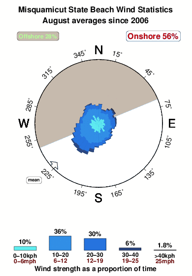


Wind stats for Misquamicut State Beach: see the variation in direction and stength by month.
Photos de Surf
de la galerieContours: Routes et Rivières: Sélectionnez un spot de surf du menu 


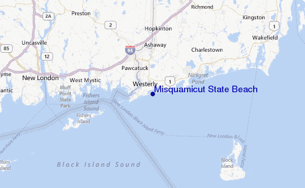
Utilisez cette carte en relief pour naviguer vers les spots de surf de Rhode Island, et les stations de marées aux alentours de Misquamicut State Beach
Spots de Surf les plus proches de Misquamicut State Beach:
(Cliquez sur le nom du spot pour plus de détails)- Closest spot2 mi
- Second closest spot2 mi
- Third closest spot3 mi
- Fourth closest spot4 mi
- Fifth closest spot4 mi
Bouées marines les plus proches de Misquamicut State Beach:
- Closest Bouées marines42 mi
- Second closest Bouées marines46 mi
- Third closest Bouées marines47 mi
- Fourth closest Bouées marines84 mi
- Fifth closest Bouées marines84 mi
Stations de marée les plus proches de Misquamicut State Beach:
- Closest station de maréeWeekapaug Point, Block Island Sound2 mi
- Second closest station de maréeWatch Hill Point4 mi
- Third closest station de maréeWesterly, Pawcatuck River4 mi
- Fourth closest station de maréeStonington, Fishers Island Sound6 mi
- Fifth closest station de maréeCharlestown9 mi
Airports
- The closest passenger airport to Misquamicut State Beach is Theodore Francis Green State (Providence) Airport (PVD) in USA, 54 km (34 miles) away (directly).
- The second nearest airport to Misquamicut State Beach is North Central State (Smithfield) Airport (SFZ), also in USA, 71 km (44 miles) away.
- Third is Hartford Brainard Airport (HFD) in USA, 85 km (53 miles) away.
- The Francis S Gabreski (West Hampton Beach) Airport (FOK) in USA is 88 km (55 miles) away.
- Bradley International (Windsor Locks) Airport (BDL), also in USA is the fifth nearest airport to Misquamicut State Beach and is 101 km (63 miles) away.

- /breaks/Misquamicut-State-Beach/forecasts/latest


 Nearest